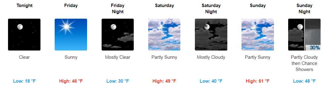
If you’re going to the Titans game, it’s going to be cold and windy, bundle up. Winds will run 8-11 MPH by game time. As precip falls later in the afternoon, winds will pick up too. By tonight winds may gust to 28 MPH.
Temps should fall into the low-40s this evening before dipping into the 30s overnight.
Overall, the majority of our area received anywhere from 2.5″ to 3″ of rainfall from yesterday into overnight’s rain. For this reason, we do have a river currently under a flood advisory as this water runs off.

Bands of showers continue to push through Middle Tennessee with heavier showers on the way later tonight.

For real-time radar & updates: https://nashvillesevereweather.com/realtime
Hazards:

Since writing the blog this morning, NWS Nashville has since gone ahead and issued a Flash Flood Watch for Friday and Saturday:


To provide a general overview of how things are expected to play out, here’s a solution by the latest GFS model:

The last bit of showers continues to move eastward, leaving us with cloudy skies through the overnight hours. Don’t be surprised if some fog develops overnight. Fog should mix out during the early morning hours.

Fairly dreary day today with showers hanging around through the majority of it. You will want to keep those umbrellas handy.
https://giphy.com/gifs/willandgrace-episode-2-nbc-l1J9rMqPQ8c2HfxiE
Bands of showers will continue to move through Middle TN at least through the afternoon hours. Most models show these showers tapering off as we reach the evening hours.

Latest HRRR Model Loop
\
The latest hydrologic outlook from NWS Nashville says it all:

Rain will likely start after sunset tonight and continue through the day on Wednesday. Rain will finally come to an end, but only briefly, early Thursday morning.

Mostly cloudy skies expected overnight tonight with temps falling into the low-40s. Do not be surprised if you wake up to some patchy fog tomorrow morning.

Highs look to bounce through the mid-50s to lower-60s through the rest of the week. Wednesday night and Thursday look to be our driest period through it all.

Maybe a little fog early.
Rain should begin Tuesday night.
Southern Middle Tennessee should see the most rain, a real soaker, more than 2″.

It’s possible the models are a bit off and we will see that very heavy rain here.
This gross cold rain should end before or by noon, replaced by drizzly foggy funk beneath a blanket of clouds.
From NWS-Nashville:
The last recorded rainfall at Nashville airport was back on December 5th. While today`s rainfall isn`t going to go far to relieve us from this latest snap of dry weather, we will make up for it through the rest of this week.
A sprinkle is possible but no measurable rainfall is expected. A forgotten umbrella is no big deal.
You must be logged in to post a comment.