Sunny Skies To Start the Weekend!

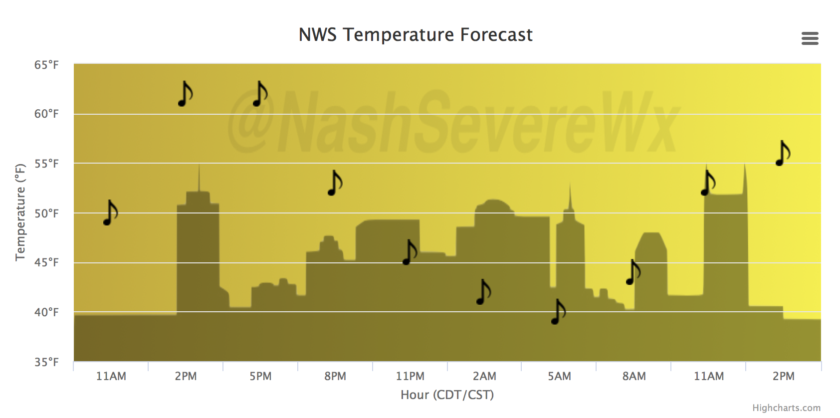
Editor’s Note: Brendan’s Last Day

Today we say goodbye to one of our interns, Brendan Schaper. As you probably know, interns draft all blog content Monday through Saturday (Will, Andrew, and I have full time jobs and fuller time families). Our internts are meteorology students at Mississippi State University. They volunteer their time and work very hard to produce good information for you. Along the way they get better at communicating weather information; after all, writing is a muscle, it strengthens with use. Most of what you read from our interns is edited by me, Will, or Andrew, but I have not had to edit anything Brendan has done for more than a year. He is outstanding. He’s graduating this Spring and has a coveted job for the National Weather Service waiting for him. We are going to miss him. Thanks for the work, Brendan. We consider you a friend and look forward to seeing what you do down the road.

Cooler Today, Clouds Return Quickly


NWS Temperature Trend

[av_textblock av_uid=’av-ohcj00′]
[cjtoolbox name=’Treg DONT DELETE’]
[/av_textblock]

With high pressure sinking southward into Illinois overnight, we expect some clearing to take place. Depending on how much clearing occurs will have an impact on how low tonight’s temperatures sink; however, there is enough confidence in 30ºF temperatures that a Frost Advisory has been issued.

Frost Advisory 1AM-8AM Friday

Clear and calm conditions will begin tomorrow, including a nice temperature rebound! Afternoon highs for your Friday will soar into the upper 60, with a few spots reaching 70ºF. Saturday will be the pick day of the weekend, with everyone seeing 70s during the afternoon.

Rain Returns Sunday, On-and-Off Through Tuesday

GFS Model Sunday-Tuesday

A relatively weak, but slow-moving/efficient low pressure system is expected to develop over the Lower Mississippi River Valley this weekend. As it slides to the east, we will remain on its northern edge, but close enough to receive some appreciable rainfall. 1-2″ is possible Sunday through late Tuesday, with rain becoming more isolated in nature during the day on Tuesday.


Tornado Watch Cancelled, Colder Air Set to Move In

Note: The tornado watch is cancelled

Storms ending, now cold and snow?

Oh boy, only in Nashville! Storms this afternoon are quickly moving east and we turn our attention to cooler air and a change in wind direction tonight.

NWS Temperature Trend

Temperatures will be below the 50ºF mark by tomorrow morning and will continue to fall through the day. The latest run of the NAM and GFS models show some shower activity during the day Tuesday, possibly transitioning to snow showers Tuesday night.

Latest NAM Loop Tuesday PM – Wednesday AM

Accumulations aren’t likely and this shouldn’t be an impactful setup…but stay tuned for any changes. Temperatures will warm beginning Wednesday into next weekend, ahead of another unsettled weather pattern that could bring more rain to the area as early as Friday.


Tornado Watch In Effect Until 1100PM

Probabilities


Severe Weather Expected This Afternoon/Evening

Severe Weather Timing per NWS Nashville

Good morning, all. We are expecting strong to severe thunderstorms today, with all hazards (large hail, damaging winds, tornadoes) possible. Latest runs of the HRRR show that between mid-afternoon and early evening will be our best opportunity for menacing storms to race across Middle Tennessee:

Latest HRRR Loop

The Storm Prediction Center has placed Davidson/Williamson Counties under an “Enhanced Risk” (3 out of 0-5 scale) for severe thunderstorms today. The individual breakdowns of each hazard (hail, wind, tornado) are outlined below:

SPC Convective Outlook for Tennessee

Expected Hazards

Hail Threat – HATCHED AREA…10% or greater probability of two inch diameter hail or larger within 25 miles of a point, otherwise 15% probability of one inch diameter hail or larger within 25 miles of a point.

Damaging Wind Threat – 15% probability of damaging thunderstorm winds or wind gusts of 50 knots or higher within 25 miles of a point.

Tornado Threat – HATCHED AREA…10% or greater probability of EF2 – EF5 tornadoes within 25 miles of a point, otherwise 10% probability of a tornado within 25 miles of a point.

Uncertainty…

Dewpoints. Right now we are around 48 degrees, while models suggest we will surge into the upper 50s to near 60 degrees by this afternoon. If that happens, our atmosphere will be more than primed for severe thunderstorms. However, if dewpoints stay down, that would help our case in lowering the severe weather threat.

Overall, areas to our south have an even greater potential for severe storms and tornadoes. On the contrary, we will have a very precise window of opportunity this afternoon/evening for rotating, vigorous thunderstorms.

Schools are releasing early for a reason. If you have plans to be out and about this afternoon/evening…

Pay close attention to frequent weather updates from multiple media sources. Reduce travel if at all possible. Have a safe place in mind to go if you get severe storm/tornado warned. Helmets, blankets, anything to protect you from projectiles (flying debris) will only be to your advantage.

We will provide further updates throughout the day today here on the blog and much more frequently @NashSevereWx on Twitter. Thanks for sticking with us.


A Forecast Worth Watching. Has “Bracket-Bust” Potential, Though.

Partly Sunny, Clouds Still Hang Out With Us Today

GOES East Loop This Morning

*Geek out moment*: Notice that band of clouds over Northwest Tennessee? That’s out ahead of a cold front! This front will slide through the area today bringing cooler (but not terribly cold) air for tomorrow. As long as we get intermittent sunshine today, temperatures are expected to soar into the upper 70s

Today’s HRRR Model Loop

Today’s frontal passage could pop a few showers from Nashville proper to areas of east of downtown. Shouldn’t be a big deal, but an umbrella can’t be written off yet…especially from 3PM-7PM.

Active Period Sunday Night-Monday, Potential for Strong Storms

SPC Day 3 Convective Outlook (Slight Risk for Nashville, “2” on a 0-5 scale)

Disclaimer: the following thoughts are preliminary and subject to change. Having uncertainty and working through the uncertainty will serve up a better end-product, rather than splattering a few models runs out here and climbing aboard a “hype train”.

Remember some severe weather ingredients:

  • Instability (CAPE)
  • Wind Shear
  • Lift (gets air to rise)
  • Moisture

SO…which one or all of these will Middle Tennessee have late Sunday into Monday?

GFS Model

✓ Lift
✓ Moisture

…missing two important ingredients.

NAM Model

✓ Instability
✓ Wind Shear
✓ Lift
✓ Moisture

…has everything but the kitchen sink.

and the European Model is siding more with the GFS on having only marginal ingredients for the development of severe storms.

What to Expect

Sunday will be dry for the first half of the day. Moisture quickly spreads northeast into Middle Tennessee by the afternoon and evening hours, when showers and a storm are expected to begin. Some of the rain could even be heavy at times.

See that low pressure system moving into Oklahoma by the end of that GIF above? The position of that is CRITICAL, in terms of our risk for severe weather.

  • If the low tracks over us or to the south, severe weather risk remains LOW.
  • If the low tracks to our north and west, severe weather risk goes UP.

Also important to watch is how much the atmosphere does/does not destabilize on Monday. More rain and less sunshine would lead to a less volatile setup, and vice versa.

Storms capable of large hail and strong winds are possible late Sunday and through the day on Monday. Models are still figuring out timing on this progressive system, and we hope to know more by this time tomorrow. The Monday morning commute/lunch hour could be interesting, so stay tuned.

Beyond Monday, Colder and Leftover Rain

As Monday’s low pressure pulls away, it will leave behind the chance for some showers and noticeably cooler air. Highs Tue-Thu will be bounce between the upper 40s and low 50s. More showers and a few storms look possible, in addition to a slight warming trend, next weekend.


Dry Friday, Weekend is Wet, But Models Not Agreeing On How Much

Warmer Day On the Way

A southerly breeze will bump temperatures into the middle 50s today, and while some clouds will be passing through, there will be enough sunshine to get us there. It’s Friday! And for some of the kiddos/teachers/college folk out there, Spring Break officially begins today. Road conditions will be most optimal today for heading south. Rain and a few storms will make driving less pleasant on Saturday, detailed below. If you’ll be a beach bum like me, don’t forget the SPF 1,000 sunscreen.

NWS Temperature Trend

[av_textblock av_uid=’av-qrordn’]
[cjtoolbox name=’Treg DONT DELETE’]
[/av_textblock]

Rain Late Tonight, Better Chances Saturday Evening

Models are misbehaving recently, keeping this weekend’s precipitation solutions a bit uncertain. Will it rain? Yes. Will it thunder? The GFS is the only one that remotely thinks so. The NAM is kind of the moderator between a colder, less precip solution and a wetter, warmer GFS. All in all, between early Saturday morning and Sunday night, anywhere from 0.5-1.5″ of rain could fall.

GFS vs. NAM Precipitation Accumulation through Sunday

Lotta’ wet.

Not so much.

IF…and that’s a big if…precipitation hangs around later on Sunday into Monday morning and colder air is able to dig further south, light rain could mix with some snow. That’s far from a guarantee, in fact it’s short of a stretch at this point. But it is a possibility worth watching headed into the beginning of next week.

Daylight Savings Time Begins Sunday Morning

Next Week, Less Wet Weather and Cool

Relatively cooler conditions will take a stake in Middle Tennessee weather next week, with a potential warm up coming later in the week and the following week. Ride the temperature wave!


Gorgeous Sunday, Rainy Monday, Cooler Week Ahead

We have one more dry day left, and luckily it will be sunny and warm! High pressure is still in control of our weather pattern but will soon slide to the east, allowing a return southerly flow to kick in. Temperatures today are expected to bounce back into the lower and middle 60s areawide.

A south wind this evening will bring in warmer and more moist air, leading to an increase in clouds tonight and rain by midday Monday.

GFS Model Loop

The silver linings to a rainy start to the week is that a) we don’t expect a heavy rain event (0.25″ avg precipitation accumulation) and b) we will remain mostly dry until next weekend.

GFS Precipitation Accumulation Through Wednesday — note: this model run may be overdoing the total accumulations.

Temperatures will plummet on Tuesday, leaving us with a low of 37ºF Wednesday morning. Don’t put away the coats and long sleeves quite yet! Wednesday and Thursday, afternoon temperatures will only reach the mid 40s, meaning that Monday’s cold front is definitely going to be impactful. By Friday and Saturday of this week, things should warm back up but at the price of more rain during the day on Saturday.


Additional Rainfall, Flooding Concerns, Dry This Weekend


Rain Keeps Falling, Rivers Keep Rising

Flood Watch in Effect

A flood watch has been issued for all of Middle TN from this afternoon until noon Thursday. 2 to 6 inches will be possible causing localized flash flooding and further rise on area rivers, stream and creeks. Please remain weather aware today and tomorrow.

Latest HRRR Loop

Showers are beginning to fill in from west to east across Middle TN, especially south of the Nashville metro. The trend today will be increasing moisture and low-level convergence setting the stage for a moderate to heavy rainfall event this afternoon through Thursday morning.

NWS Rainfall Forecast

2-3″ are a good bet for most of us…while lesser amounts are expected in northern Davidson County. Even national centers, like the Weather Prediction Center, are highlighting us for a risk of life-threatening flooding. Don’t drive through flooded roadways!

WPC Excessive Rainfall Forecast

A few rumbles of thunder are possible overnight, too, but severe weather is not expected.

Several flood advisories remain in effect for portions of the Stones River and Cumberland River.

Cumberland River

Stones River

Cumberland River

Week’s End Dries Out, Looking Nice for Outdoor Plans

Once the rain comes to an end on Thursday, temperatures will be in the 50s (cooler) for Friday. Saturday will be sunny like Friday, but we’ll still struggle to reach 60 degrees. Sunday is the pick day of the weekend…temperatures in the lower 60s with an abundance of sunshine. Enjoy it while you can, because more rain is in the forecast for early next week!


Breath of Fresh (Dry) Air, Before More Rain Tues.-Thurs.

Sunshine is Back! For Now…

GOES East, Morning Loop

Mostly sunny skies are expected this afternoon, which will bump temperatures into the lower 60s for much of Middle Tennessee. High pressure will stick around with us today and for part of tomorrow, before quickly being shunted to the east coast. Temperatures again on Tuesday are expected to be in the 60s, but pushing 70 degrees with ample surface heating.

“Back In the Thick of Things” says NWS Nashville – More Rain This Week

GFS Model Loop Tuesday-Saturday

Showers and a few thunderstorms re-enter the picture Tuesday evening into Wednesday morning. Models have been depicting at least 1-2″ of total rainfall through Thursday night for us in Davidson/Williamson Counties, with higher amounts closer to Alabama. Since rain will be starting Tuesday night and be stretched over a duration of two days, flash flooding isn’t of highest concern — however, this additional rainfall will put more stress on area rivers and streams.

WPC Rainfall Forecast through next Monday

In terms of thunderstorms misbehaving like this weekend, this is not expected with this mid-week rainmaker. Severe weather will be much further to our south and west over Arkansas and western Mississippi on Wednesday. Right now, there don’t seem to be enough ingredients for rigorous thunderstorm development on Thursday either. The main focus will remain on heavy rain and where the highest rainfall totals are set up.

Hang On Folks, The Sun Will Return

Rain will come to an end late Thursday, leaving dry conditions in its wake. If you’ve been waiting for a dry weekend to get outdoors, this may be your next chance. Temperatures will be a bit cooler than what we’ve been having (highs in the upper 50s), but *dry weather* is the key phrase here. Beyond the weekend, rain could return by the beginning of next week.

Flood Advisory – Cumberland River

The Flood Advisory is extended for The Cumberland River At Nashville
* Until Thursday evening.
* At 8 AM Monday the stage was 30.4 feet.
* Flood stage is 40.0 feet.
* Action stage is 30.0 feet.
* The river will continue to rise to near 31.2 feet by this afternoon.
* At 32.0 feet…Further inundation of low lying areas along the river is occurring including the riverfront landing and recreation areas near Nissan Stadium.
* At 30.0 feet…Water reaches the first grassy area of the riverfront landing, and the access point on the east side of the river near Nissan Stadium.
* At 25.0 feet…The riverfront recreation areas on both sides of the river begin to be inundated.


Severe Weather Possible Saturday Night, Some Dry Days Next Week


Flood Watch In Effect through Saturday Night

NWS Nashville: A Flood Watch continues to be in effect for portions of Middle TN through Saturday night. While most will see a lull in the rain Friday, those in the watch will not. Additional rainfall is expected Saturday, as well. Both localized Flash Flooding and river flooding will be possible by Saturday night. Those who experienced flooding this past week and are in this Flood Watch need to pay special attention to rainfall accumulations as flooding is expected to return to those locations.

Focus is On Saturday’s Storms and Severe Potential

A warm front is expected to develop, attached to a strengthening low pressure system over the Plains. This low pressure will continue to strengthen and move northeast across the mid and upper Mississippi Valley, dragging a cold front along with it, further south. That’s where we will be, waiting on a cold front Saturday evening/night.

In agreement with NWS Nashville, this system very much resembles a springtime setup and latest model data shows that storm ingredients (instability and wind shear) will be somewhat impressive as storms move into Middle Tennessee Saturday night. The latest SPC outlook keeps Nashville in a “Slight Risk” (2 out of 5 risk), while areas to our west were upgraded this morning to an enhanced risk of severe weather.

SPC Day 2 Outlook

All hazards, including large hail, damaging winds, and a few tornadoes. Damaging straight-line winds are the main concern with these storms.

Details on the isolated tornado threat…

NAM – most aggressive model. Has the lowest level winds of the atmosphere generously conducive for the development of tornadoes.

GFS – a bit less aggressive. Low level winds a bit less “intense” in terms of the development of tornadoes.

Grounds are already saturated, so any type of wind (thunderstorm gust or isolated tornado) will have a greater potential to bring down trees.

When does this all start?

Timing appears to be Saturday night evening into early Sunday morning. Models seem to be a bit slow right now with this event, meaning the approach of severe weather may be earlier in the evening than they currently depict. Stay tuned on timing adjustments.

Time to check those batteries and the status of your NOAA Weather Radio. If you have a weather radio app, make sure notifications are turned on. Statistically, storms inherently become more dangerous under the cloak of darkness. Have multiple reliable sources to get information from Saturday night! We all plan to have a late night, keeping you informed of the latest weather headlines, so stick with us here and @NashSevereWx on Twitter.

Next Week – Dry Days With Another Heavy Rainmaker Midweek

GFS Model Loop Next Week 

Temperatures will remain mild each afternoon, generally in the lower to middle 60s. A heavy rainmaker (2-3″ possible) is expected to move into the area on Wednesday, ending Thursday. Flash flooding may be more of an issue then, as compared to Saturday’s system.

Reminder: Saturday is Severe Weather Awareness Day

Be sure to join us for SWAD 2018! Lots of fun activities for families and your inner weather nerd.