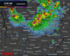
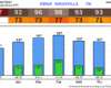
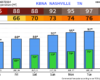
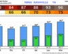
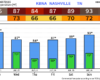
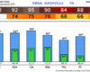
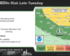
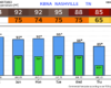
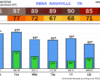
Our high temperatures will sit comfortably above our average high for this time of year (mid 60s) all week long. In fact, our low temps will match our average high temps.
Highs in the low to mid 80s will be common thru Saturday. Hello Spring.
Our high temperatures will sit comfortably above our average high for this time of year (mid 60s) all week long. In fact, our low temps will match our average high temps.
Highs in the low to mid 80s will be common thru Saturday. Hello Spring.
Cooler temperatures today as cloud cover hangs around for most of the day. Our rain chances will increase starting this afternoon as a cold front moves thru.
Not expecting any storms, just some showers. Rainfall totals will be very light, 0.2″ at most.
We’ll be keeping an eye on the thermometer today. Our forecast high of 86° would tie our daily record high of 86° set in 2007. Regardless of if we get there or not, it’ll be very warm, ~20° above average.
After two straight days of tying the daily record high (89° and 88° for Saturday and Sunday, respectively), a cold front has moved thru and cooled us down to closer to average for this time of the year.
We’ll have some flurries (maybe some graupel) flying around today, because why not. It was 79° yesterday.
No impacts expected. Maybeeee a dusting on some elevated surfaces or grassy areas, but again – it was 79° yesterday and most flakes will splat:melt on contact with the ground.
A strong storm system moving across the Plains today will push a cold front through middle Tennessee tonight, bringing the risk of severe weather to Davidson and Williamson counties. The Storm Prediction Center has placed much of the area in an Enhanced Risk, which means scattered severe storms are expected and a few could be intense. The main story tonight is damaging winds and a secondary risk for tornadoes. We’re watching for CAPE to build as the line approaches which could make storms more intense. We’re also watching for dry air near the surface to pull stonger elevated winds down to the surface. Today is a day to stay weather aware and make sure your family has a plan to shelter in the even of a tornado warning. Let’s dive into the details.
Before we get into the severe talk, today thru Sunday afternoon will be nice. Well above average temperatures, with plenty of sun.
A Wind Advisory will go into effect starting at 1p on Sunday. Wind gusts before the storms may reach up to 40 mph. Be sure to secure any outdoor furniture – also not a bad idea to take care of any lingering tree branches that may be damaged from the ice storm if you are able to.
Before we get into the severe weather talk, I will briefly hit on today and Saturday. Which there’s not much to talk about, the rest of today and Saturday will be quite nice. Cold temps tonight, but we warm up nicely on Saturday with highs in the mid 70s – no rain.

Stay connected. Isolated intense storms are possible today with the chances of seeing these things within 25 miles of you…and associated odds: Tornado (2%), Damaging Straight-Line Wind (15%), Large Hail (5%).

Take a look at that! Something for everyone. 50, 60, 70 for the last-half of the week and weekend. Incredible! And dry! Dew points will stay below 50º the whole time. Can’t say enough about it.
You must be logged in to post a comment.