Flooding and Severe Threat This Weekend
Saturday, July 11, 2026 · Will
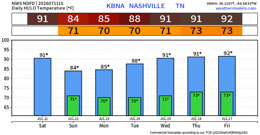
We are outlooked at a Slight Risk (2/5) for severe storms this afternoon and evening. Damaging wind is the main concern. But the headline that lasts longer than today is water — a Flood Watch is in effect for all of Middle Tennessee through 6 PM Sunday, with another 1–3 inches of rain possible on top of what’s already fallen.

Today Into Tonight
NWS-Nashville laid it out this morning:
There’s a “Slight Risk” (level 2 of 5) for severe thunderstorms across Middle Tennessee this afternoon and evening. Damaging winds are the main concern.
Scattered showers and storms are in the forecast through the day, with coverage peaking in the afternoon and evening as an MCV — the leftover mid-level spin from last night’s storms up north — rolls into a moisture-loaded airmass. High near 90 before temps back off into the mid 80s under the clouds and rain. Heat index up around 99 before the storms take over.


Confidence on rotating storms is low, and the office notes lapse rates aren’t impressive enough for much of a hail threat. So: wind is the hazard to plan around, and heavy rain is the hazard to plan around even harder.
Overnight, storm chances taper but don’t fully quit. Low near 70.
Sunday — Boundary Parks Over Us
A stalled boundary keeps us in the same pattern Sunday. Scattered showers and storms through the day, high near 83, with rain chances lingering into Sunday night. Flood Watch runs all the way to 6 PM Sunday.
From NWS-Nashville:
Heavy rain will be the biggest concern through the weekend with an additional 1-3″ expected across the area. Locally higher amounts will be possible in stronger and/or training storms, which could lead to flash flooding.
Training storms — thunderstorms that keep redeveloping over the same neighborhoods like train cars on a track — are the mechanism to worry about. Where exactly the heaviest axis sets up is hard to pin down and depends on how those outflow boundaries interact.

Monday and the Transition
Monday still looks unsettled. High near 84 with showers and storms likely, especially into the afternoon and evening. Heavy downpours remain possible. After that, an upper-level ridge builds in from the west and starts to shove the wet pattern out.
Midweek and Beyond
Tuesday still carries a decent rain chance (around 50%) with a high near 86, then things dry out noticeably. Wednesday looks mostly sunny and near 89. Thursday and Friday: sunny to mostly sunny, highs right at 90, with a stray afternoon storm possible each day but nothing widespread.
The tradeoff for the drier air is heat. NWS-Nashville is flagging triple-digit heat indices possible Thursday through Saturday. We’ll keep an eye on that as it gets closer.
What to Do
- Take flooding seriously. Turn around, don’t drown. Most flash-flood deaths happen in vehicles. If a road is covered, find another way.
- Have a way to get warnings on your phone this afternoon and evening — the wind threat is the kind that can flare up quickly on a single cell.
- Bring in or secure loose outdoor stuff before you head out today. Damaging wind gusts don’t care about your patio umbrella.
- If you’re outside this afternoon, keep an eye on the sky and have a plan to get indoors.
Could change, as usual. Stay connected.
Prepared Not Scared.