
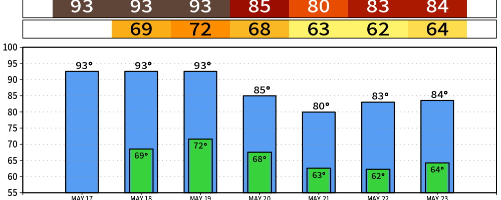
TLDR: Two more summer-like days before a wetter pattern moves in late Tuesday into Wednesday.
Today and Tonight
Sunny and warm. High near 91 with a south wind 10 to 15 mph and gusts to 25. NWS-Nashville notes this is the first time many spots west of the Plateau hit the low-90s this year. Tonight stays mostly clear and mild, low around 68.
Monday
A repeat. Mostly sunny, high near 91, breezy out of the south. Monday night turns mostly cloudy as moisture starts working back in ahead of the next system. Low around 71.
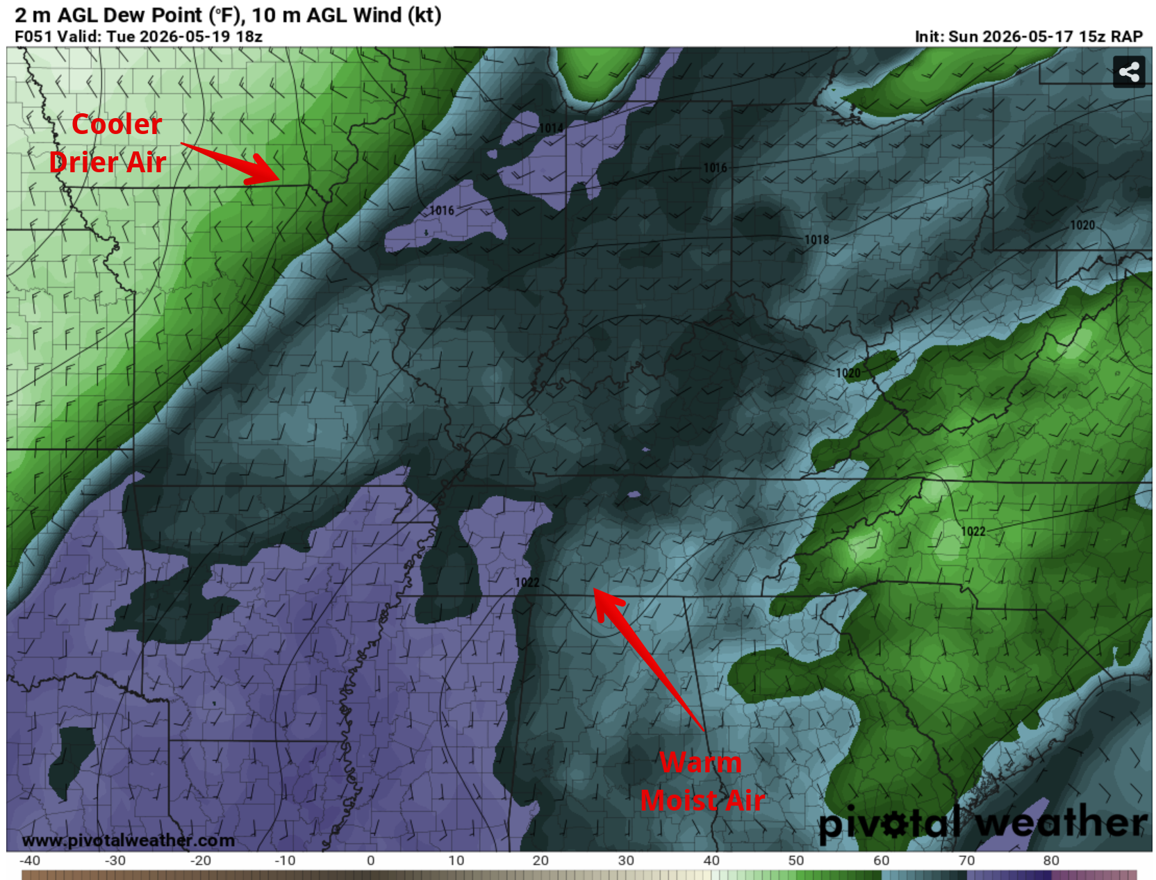
Tuesday — Rain Chances Arrive
Still warm, still near 91, but a chance of showers and thunderstorms moves in during the afternoon and ramps up Tuesday night. Rain chances climb from around 30% in the afternoon to 60%+ overnight.
From NWS-Nashville’s morning discussion:
Medium to high chances for showers and storms start late Tuesday into Wednesday. Additional rain chances late week may push totals over 2 inches.
A large upper-level trough developing over the Plains is pulling deeper moisture our way — precipitable water over 1.5 inches by Tuesday. That’s the kind of airmass that produces good soaking rain, which we need.
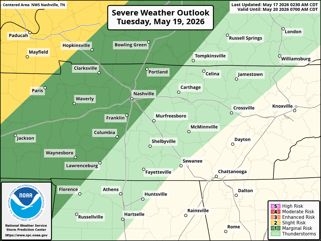
On the severe side, the office flags it but isn’t impressed:
It is several days out still to talk about any potential for hazardous weather, but it is worth noting that the setup doesn’t look favorable right now with better shear to the north and displaced from the higher instability to the south.
SPC has Davidson and most of Williamson in a Marginal (1/5) for Tuesday — the lowest tier — alongside a general thunderstorm area. Translation: storms are likely, a stray strong one is possible, but this is not shaping up as a widespread severe event. Could change, as usual.
Wednesday — the Wettest Day
Showers and thunderstorms look likely through the day and into Wednesday night as the front pushes through. High only around 84. Rain chances in the 80% range. This is the day to expect the most rainfall.
Rest of the Week
Behind the front, temperatures drop back to something that feels like actual May — highs in the upper 70s to low 80s Thursday through the weekend. Rain chances don’t fully shut off either. Thursday through Saturday with periodic showers and storms.
NWS-Nashville is honest about the uncertainty:
Low confidence in the overall pattern late next week, but it looks to remain unsettled enough to keep low to medium rain chances in the forecast beyond Thursday.
Stay connected.
Prepared Not Scared.
Categories: Featured Blog