
Bottom line: hot and mostly quiet through Monday across Davidson and Williamson. Our next real rain chance arrives Tuesday and lingers into Wednesday. We are not severe outlooked.
This Weekend — Summer Vibe
Today tops out near 87° under partly sunny skies, with a south-southwest wind 10 to 15 mph gusting near 25. There’s a low rain chance in the forecast, but per NWS-Nashville that activity should stay up near the Kentucky border — not really our problem.
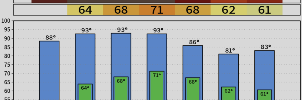
Tonight stays mild and partly cloudy, low around 64°.
Sunday is the day Nashville likely notches its first 90° of the year. Sunny, high near 91°, south wind 5 to 15 mph with gusts to 25. NWS-Nashville’s read:
Nashville’s first 90 degree day appears inevitable on Sunday with many locations west of the Plateau getting into the low-90s.
Sunday night stays warm and mostly clear, low around 68°.
Monday — Still Hot, Still Dry

Mostly sunny and 92°. South wind 10 to 15 with gusts to 25. Rain chances stay near zero during the day. Clouds increase Monday night ahead of the next system, low around 71°.
Tuesday Into Wednesday — the Actual Rain Chance
This is where the pattern flips. A large trough and cold front move in from the west, and rain chances climb through the day Tuesday and ramp up Tuesday night.
- Tuesday: showers and thunderstorms possible after 7 a.m., high near 91°, PoP 40%.
- Tuesday night: showers and storms become likely, low around 67°, PoP 60%.
NWS-Nashville on the midweek setup:
Late Tuesday and into Wednesday has the highest rain chances. Probability of exceeding 0.50″ through Wednesday has come up to around 70-80% with the western half of Middle TN being favored for higher amounts.
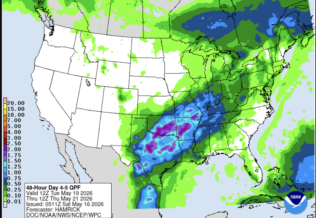
Roughly 40–50% chance of more than an inch out west by the time this is done. The QPF above gives us some insight into rainfall amounts. Nothing in the brief points to a severe weather threat at this range — just a needed, soaking rain chance. Could change, as usual.
Back Half of the Week
The front slides south late Wednesday into Thursday, and rain lingers behind it Thursday before drier air filters in from the north. Temperatures back off to something more seasonable, then start climbing again by next weekend.
What to Do
- Hydrate this weekend. If you’re not used to mid-90s heat indices yet, your body isn’t either. Take it easy outside on Sunday and Monday.
- Check on pets, kids, and neighbors without working A/C.
- Keep Tuesday and Wednesday on your radar for storms and downpours.
Categories: Featured Blog