Nashville Severe Weather

Severe & Winter Weather Info and Forecasts for Davidson & Williamson Counties in Middle Tennessee

Sunday, May 17th, 2026

Menu

  • Home
  • Who We Are
    • About Us
    • Mike & Albree
  • Resources
    • Radar
    • NWS Nashville
    • What To Do: Tornado Watch vs. Warning
    • River/Creek Flood Stages
    • Taking Care of Storm Anxiety
  • Shop Merch
    • Store
    • Shopping Cart
  • Donate
  • Follow us on Twitter
  • Follow us on Threads
  • Follow us on Bluesky
  • Follow us on Instagram
  • Subscribe to our YouTube Channel

Grad Party Needs A Rain Plan

By Will on Sunday, May 17, 2026 @ 12:10 pm • ( Leave a comment )

Hot then a Rain Chance

By Will on Saturday, May 16, 2026 @ 10:36 am • ( Leave a comment )

Great Weather, But…

By Will on Friday, May 15, 2026 @ 9:02 am • ( Leave a comment )

More Sunny Days

By Will on Thursday, May 14, 2026 @ 1:06 pm • ( Leave a comment )

Down Then Up

By Will on Wednesday, May 13, 2026 @ 4:48 pm • ( Leave a comment )

Spring and Summer in One Week

By Will on Tuesday, May 12, 2026 @ 8:14 am • ( Leave a comment )

Drying Out. Next Rain Event Late Wednesday (but really, Thursday).

By David on Sunday, March 10, 2019 @ 9:03 am

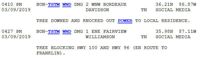
Last night’s storm reports weren’t from storms but from the Wind Advisory. “Non thunderstorm-winds,” they call it.

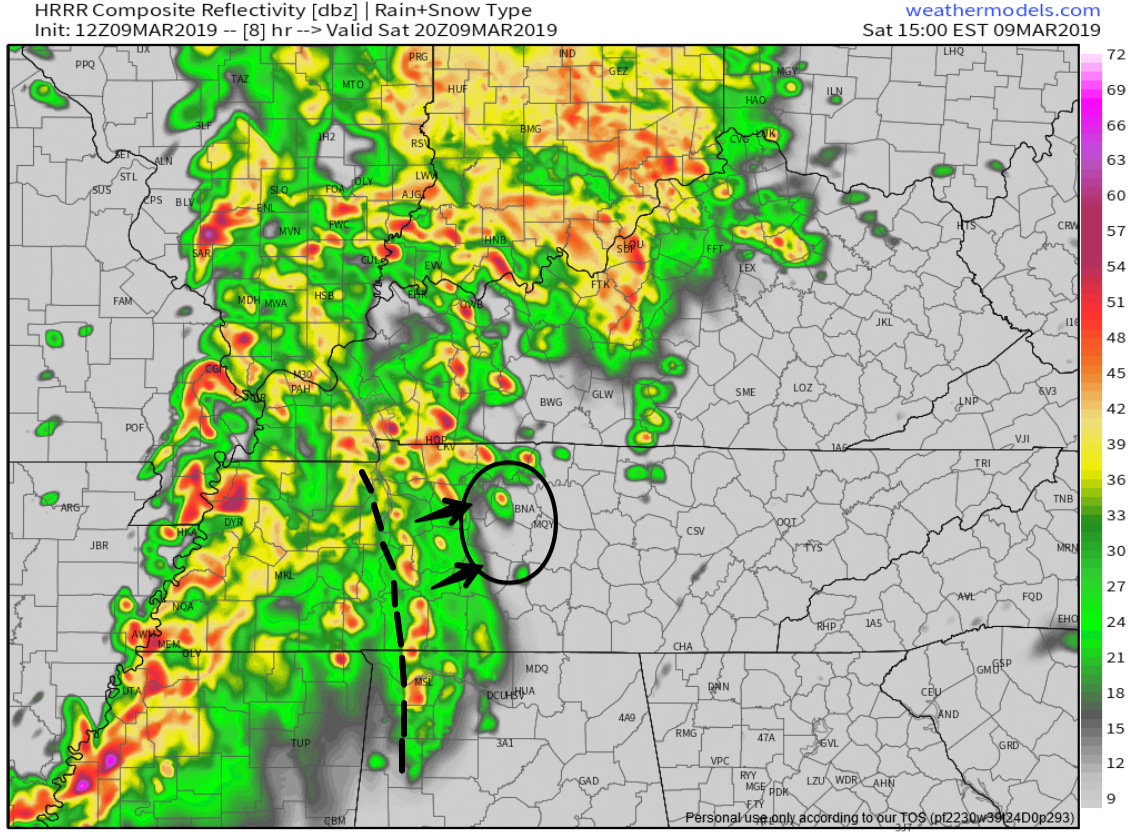
Rain reached 2″+ in spots yesterday. Creeks and streams rose quickly and fell not as quickly. A few rivers reached pre-flood “action stage.” For more on that, this. read more

Rain is Ending, Tornado/Storm Threat Has Moved East; Sunny Start to the Week!

By Marti Calhoun on Saturday, March 9, 2019 @ 7:58 pm

The rain is over. Storms have moved on to our east, allowing for our the tornado watch including Davidson and Williamson counties to be cancelled. We remain under a wind advisory until 9PM.

Sustained winds of 15 to 20 mph, gusting up to 30 mph, are expected for another hour or so, becoming calm by midnight. read more

Tornado Watch until 9 PM. Tornado, Damaging Wind, Hail Probabilities, ETAs.

By Marti Calhoun on Saturday, March 9, 2019 @ 2:51 pm

Severe weather requires the right ingredients coming together at the right time. Severe weather ingredients may come together this afternoon and/or early tonight.

When

Two waves of storms, both with severe potential. read more

Two Waves of Storms Today, Severe Thunderstorms Possible: Wind, Tornado, Hail, Flooding Probabilities, ETAs

By David on Saturday, March 9, 2019 @ 10:32 am

Severe weather requires the right ingredients coming together at the right time. Severe weather ingredients may come together this afternoon and/or early tonight.

When

Two waves of storms, both with severe potential. read more

Showers Continue Today; Severe Storm Possibilities Saturday; Nice Sunday

By Andrew on Friday, March 8, 2019 @ 12:35 pm

Story #1: Strong/Severe Storm Potential Saturday

The Storm Prediction Center has assigned a “2 out of 5” risk category for most of us on Saturday. Areas W of 65 has been in an Enhanced or “3 out of 5” risk category.

  read more

Pleasant & Dry Today; Rain Chances Return Tonight; Rain All Day Friday; Severe Storms (?) Saturday

By Marti Calhoun on Thursday, March 7, 2019 @ 11:11 am

Today we’ll be mostly cloudy, cool, and dry through the early evening hours. Afternoon high will be around 50° here in Nashville.

Rain chances will increase after sunset as our next big rainmaker arrives. Scattered drizzles could begin around 9PM tonight, becoming rain by midnight. read more

1

Cold for Now, Thunderstorms Arrive in Time for the Weekend

By Alex Forbes on Wednesday, March 6, 2019 @ 11:20 am

Cold and Mostly Clear…For Now

We are going to be sitting 18º below our average high of 58º today.

Expect an afternoon high of around 40º with a west wind, 5-10 mph. Clear skies will give way to a partly cloudy night across WIlliamson and Davidson Counties. An overnight low of 24º is expected. At least it’s not in the teens! read more

Few More Cold Days, Then Rainy/Storm Season Gets Cranking Again

By David on Tuesday, March 5, 2019 @ 2:08 pm

Cold continues. Wind chills in the low 20°s around sundown then upper teens tonight.

Even colder tomorrow morning. Wake up low 19°, wind chill 13°.

I mean, yeah, technically it’s still winter.

Wednesday’s high is 39° – a meaningful improvement – then Thursday morning another ice boxer 24° (wind chill 21°), but 52° Thursday afternoon. read more

Unseasonably Cold Now. Snow (meh) to Rain Thursday. Rain Friday. Saturday Night Storms?

By Alex Forbes on Monday, March 4, 2019 @ 11:09 am

Start to the Work Week

March 1 may have been the start of meteorological Spring however, Old Man Winter had something to say about that. All of the rain yesterday left cold air in its wake. Temperatures this afternoon are going to struggle to make it to and above freezing. read more

Hard Freeze Overnight; Wake Up Wind Chill 11°

By David on Sunday, March 3, 2019 @ 4:59 pm

Radar images coming out of Georgia this afternoon are upsetting. Numerous tornado debris signatures, obvious tornadoes, some tearing through towns, from what’s fair to say they’re enduring: a tornado outbreak. read more

1

Posts navigation

‹ Newer 1 … 280 281 282 283 284 285 286 287 288 289 290 … 562 Older ›

Subscribe to Blog via Email

Enter your email address to subscribe and receive daily forecast updates directly to your inbox.

Privacy & Cookies: This site uses cookies. By continuing to use this website, you agree to their use.
To find out more, including how to control cookies, see here: Privacy Policy
  • Top categories: Forecast Blogs (Legacy) / Featured Blog / Tweet
Proudly powered by WordPress | Theme: Broadsheet by Pro Theme Design.
 

Loading Comments...
 

You must be logged in to post a comment.