Sunny & Warm Today; Rain Begins Late Tonight - Goes Until Tuesday

EDITORS NOTE: This is Marti’s last blog for us as an intern. She has really grown as a writer and we are very proud of her work. Best of luck, Marti!

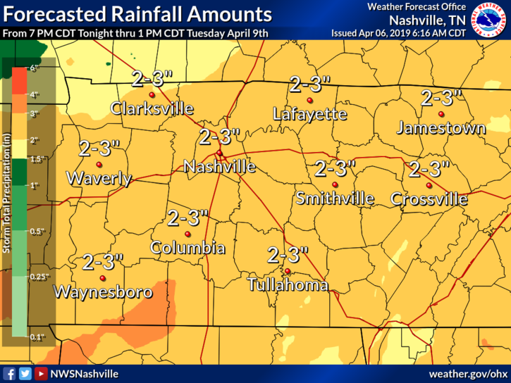
If you enjoy warm and sunny, then soak up the sunshine while we’ve got it! Starting tonight we’ll be rain-soaked until Tuesday. read more

Rain Through the Afternoon & Night; Friday Thru Saturday Afternoon Look Dry

On and Off Rain Today

Our dry, sunny skies have moved on to the east, pushed out by clouds and rain. The NAM 3km below shows the widespread rain that’s taken over the southeast.

Even with rain and clouds, our high temp will warm into the low 70°s by the afternoon. read more

Sunny & Clear Today! Warming Trend Continues; Rain/(A Few)Storms Thursday; Scattered Showers This Weekend

Warming trend continues today with clear, sunny skies. High temp in the mid 60°s. Weak high pressure is building in, cutting off any chance of rain this afternoon/evening.

Wednesday – Several Degrees Warmer

High pressure will be in control most of Wednesday. No rain expected; sunny in the morning, clouds taking over in the evening. read more

Rain and Some Storms Today; Cold and Dry Sunday; Dry and Warm for Next Work Week

Today, a low pressure center will pass to our north, bringing showers and some storms this afternoon/evening and then cold weather tomorrow.

We’ve got a warm, south wind this morning bringing warm, moist air up and into the Nashville area. This is the energy storms will use later this afternoon. SPC has placed us within a Slight (2 out of 5) Area for Severe weather today. read more

Sunny & Breezy Today; On and Off Rain Friday; Cold Front Saturday; Cool Start to Next Week!

Today’s our last day of dry, sunny skies until Sunday. It’ll be breezy today, with a few gusts of 10-20 mph possible in the afternoon.

Afternoon high will try to reach mid 70°s, but some overhead clouds could keep us a degree or two cooler this afternoon. read more

Awesome Week Ahead! Warm and Dry Through Friday Afternoon; Rain Returns Late Friday/Saturday

Cooler weather paid us a visit this morning. Temps were in the upper 30s when we walked out the door. We will remain on the cooler side today, high temps will hover in the mid 50°s.

Why the return of cooler weather? A high pressure bubble has settled right over the Ohio River Valley. Clockwise winds around the high are pushing cooler temps from the northeast down into Middle Tennessee. read more

Beautiful End to the Week; Rain Returns Sunday & Monday

Earlier sprinkles moved E, and we enjoyed some good sunshine today! The rest of the week will be dry and pleasant!

Today, a cold front draped across western Tennessee brought us breezy conditions. This weak front will slowly work its way eastward, passing Nashville tonight into Friday. read more

Clear Today; Rainy First Night of Spring; Beautiful Start to the Weekend

Another day of beautiful, Spring-like Winter-time weather is here! Afternoon temps will warm into the upper 50°s.

With very few clouds and a light breeze, it’s going to be a pleasant day to be outdoors! read more

Rain is Ending, Tornado/Storm Threat Has Moved East; Sunny Start to the Week!

The rain is over. Storms have moved on to our east, allowing for our the tornado watch including Davidson and Williamson counties to be cancelled. We remain under a wind advisory until 9PM.

Sustained winds of 15 to 20 mph, gusting up to 30 mph, are expected for another hour or so, becoming calm by midnight. read more

Tornado Watch until 9 PM. Tornado, Damaging Wind, Hail Probabilities, ETAs.

Severe weather requires the right ingredients coming together at the right time. Severe weather ingredients may come together this afternoon and/or early tonight.

When

Two waves of storms, both with severe potential. read more