
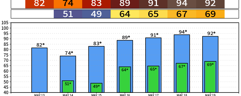
The next few days run cool and sunny, then the weekend cranks the heat back up. Nashville may finally see its first 90° of 2026. Olivia has your back.
Today and Tonight
A weak cold front is sliding through Middle Tennessee this afternoon. For us that mostly means some passing mid-level clouds and a wind shift to the northwest, with gusts up to 25 mph. If you were outside you felt it.
NWS-Nashville notes a low chance of a scattered shower or storm, but that’s pinned to the Cumberland Plateau — well east of us. We stay dry.
High near 81. Tonight clears out and cools off, with a low around 51 and a north breeze easing overnight.
Thursday — the cool day
Sunny, pleasant, and noticeably cooler. High only around 73 with a light north-northeast wind. Thursday night drops to about 48 under mostly clear skies. Open-window weather, if that’s your thing.

You can listen to the chill sounds of the NashSevereWX 24/7 stream. It’s been described by some as better than 90’s weather channel music.
Friday into the weekend — heat builds
Southerly flow returns Friday. South wind gets us back in the 80’s. Friday night brings a slight chance (20%) of showers or storms after 1 a.m. as a weak wave rides through, but nothing organized.
Saturday: Is your favorite pool open? High near 90. We stay with 90ish highs through the first part of next week.
From NWS-Nashville:
The NBM showing about a 50-70% chance that BNA reaches 90 degrees for the first time in 2026.
A note on the drought
NWS-Nashville is again flagging that the drought continues, with very little rainfall expected through the next seven days. The weekend rain chances are slim and the showers, if they form, won’t move the needle. Water your stuff.
Categories: Featured Blog