Nashville Severe Weather

Severe & Winter Weather Info and Forecasts for Davidson & Williamson Counties in Middle Tennessee

Sunday, May 17th, 2026

Menu

  • Home
  • Who We Are
    • About Us
    • Mike & Albree
  • Resources
    • Radar
    • NWS Nashville
    • What To Do: Tornado Watch vs. Warning
    • River/Creek Flood Stages
    • Taking Care of Storm Anxiety
  • Shop Merch
    • Store
    • Shopping Cart
  • Donate
  • Follow us on Twitter
  • Follow us on Threads
  • Follow us on Bluesky
  • Follow us on Instagram
  • Subscribe to our YouTube Channel

Grad Party Needs A Rain Plan

By Will on Sunday, May 17, 2026 @ 12:10 pm • ( Leave a comment )

Hot then a Rain Chance

By Will on Saturday, May 16, 2026 @ 10:36 am • ( Leave a comment )

Great Weather, But…

By Will on Friday, May 15, 2026 @ 9:02 am • ( Leave a comment )

More Sunny Days

By Will on Thursday, May 14, 2026 @ 1:06 pm • ( Leave a comment )

Down Then Up

By Will on Wednesday, May 13, 2026 @ 4:48 pm • ( Leave a comment )

Spring and Summer in One Week

By Will on Tuesday, May 12, 2026 @ 8:14 am • ( Leave a comment )

Zero to One Inch of Snow, Wet Roads + Subfreezing Temps Overnight

By David on Monday, January 28, 2019 @ 7:17 am

Windy today. High 62°.

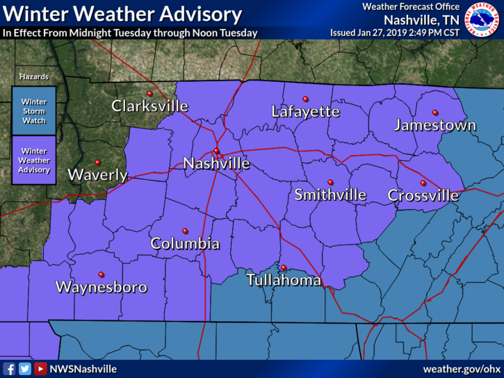
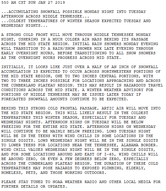
Yesterday afternoon, a Winter Weather Advisory was issued for tonight/early Tuesday morning. Winter Weather Advisories require snowfall of at least 1″.

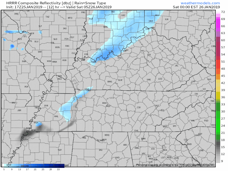
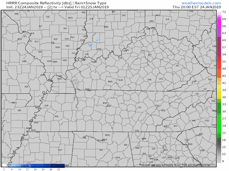
Last night, most models trended toward less snow. NAM3, HRRR, even the GFS joined the “less snow” trend advertised by the Euro model all weekend. read more

Winter Weather Advisory Midnight Monday Night – Noon Tuesday

By David on Sunday, January 27, 2019 @ 3:54 pm

It’ll be almost 60° Monday afternoon. Windy.

Monday night, warm southwest winds will turn west, then northwest, blowing in arctic air.

And with that, precip. More about this below.

Monday night after midnight, temps will nosedive below freezing, falling to 22° around sunrise. Anything wet will freeze in the early hours of Tuesday morning. read more

Tuesday Snow Update, Bitter Cold Next Week

By David on Sunday, January 27, 2019 @ 8:56 am

Pretty great today (high 49°) and Monday (high 58°!).

Rest of the week, not so much.

Tuesday’s snow potential + exceptionally cold temps prompted NWS-Nashville to issue this Special Weather Statement for all of Middle Tennessee: read more

Mostly Dry Today, Weak Cold Front Tonight; Pleasant, Dry Sunday; Wintry Weather Update

By Marti Calhoun on Saturday, January 26, 2019 @ 2:49 pm

Surface high pressure has settled over our state today bringing mostly clear skies this morning, which will become partly cloudy later today.
With few clouds in place and high pressure influence, we’ll warm into the low 40°s this afternoon. read more

Snow Tuesday: Is It Time To Party/Panic?

By David on Friday, January 25, 2019 @ 2:06 pm

You’re here to read about Tuesday so let’s speed through the weekend. (All quotes from NWS-Nashville).

BNA reported 36° after lunch. We won’t get much/any warmer today.

Back below freezing tonight and overnight with wind chills in the 20°s. read more

Possible Evening No Worries Flurries; COLD Friday Morning; Chilly Weekend; And Those Tuesday Snow Chances

By Marti Calhoun on Thursday, January 24, 2019 @ 11:52 am

At 6PM we’re sitting at 38° and looking dry. Clouds cleared out early but they’ll soon return as a cold front approaches. There was mention of very light snow flurries earlier, but now models don’t seem to be picking them up. We might be lacking the moisture needed to get snowflakes to form. read more

No Snow Tonight. Wee Hour Ice, Though?

By David on Wednesday, January 23, 2019 @ 8:23 pm

No snow tonight.

The precip moved east, faster than all models thought.

Foiled again by cold air chasing the precip.

Will Wet Roads Freeze Overnight?

At 7:25 PM, BNA reported 43°. At 8:05 PM, it’s 39°. And falling.

Rainwater continues running off the roads. Runoff means less water to freeze. read more

Wind Advisory, Rain, sNOw: It Must Be January

By Alex Forbes on Wednesday, January 23, 2019 @ 10:47 am

Wind Advisory

TIMING: Until 3 PM CST today

WINDS: Breezy south winds 20 to 25 mph with gusts around 40 mph.

IMPACTS: Gusty winds can cause tree and branch damage. Loose outdoor objects may be blown around. High profile vehicles, especially those traveling on east-west roadways, may experience travel difficulties. read more

Wednesday: Rain? Yes. Transitioning To Snow? Mehbe. Frozen Temps Thursday AM Tho. Also: Rant.

By David on Tuesday, January 22, 2019 @ 6:59 pm

Clouds are arriving. Rain is coming Wednesday, and it may turn to snow Wednesday night.

Alert! Editor’s Rant. This isn’t about you most of you. Warning: what you’re about to skip over read is indulgent and arguably therapeutic (for me). If you came here for No Rants, Just Weather, I respect that, skip the blue words. read more

Warmup Coming, sNOw Wednesday Night

By Will on Tuesday, January 22, 2019 @ 11:30 am

Today:

Today things will be warming up and quite mild overnight tonight. Breezy, but really pleasant for mid January, or early November for that matter. Rain will begin late Tuesday night as a precursor to a change coming through the day Wednesday. read more

Posts navigation

‹ Newer 1 … 285 286 287 288 289 290 291 292 293 294 295 … 562 Older ›

Subscribe to Blog via Email

Enter your email address to subscribe and receive daily forecast updates directly to your inbox.

Privacy & Cookies: This site uses cookies. By continuing to use this website, you agree to their use.
To find out more, including how to control cookies, see here: Privacy Policy
  • Top categories: Forecast Blogs (Legacy) / Featured Blog / Tweet
Proudly powered by WordPress | Theme: Broadsheet by Pro Theme Design.
 

Loading Comments...
 

You must be logged in to post a comment.