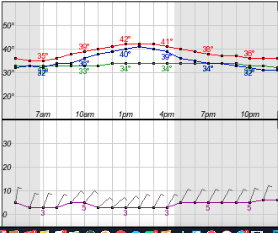
Nashville Severe Weather

Severe & Winter Weather Info and Forecasts for Davidson & Williamson Counties in Middle Tennessee

Sunday, June 7th, 2026

Menu

  • Home
  • Who We Are
    • About Us
    • Mike & Albree
  • Resources
    • Radar
    • NWS Nashville
    • What To Do: Tornado Watch vs. Warning
    • River/Creek Flood Stages
    • Taking Care of Storm Anxiety
  • Shop Merch
    • Store
    • Shopping Cart
  • Donate
  • Follow us on Twitter
  • Follow us on Threads
  • Follow us on Bluesky
  • Follow us on Instagram
  • Subscribe to our YouTube Channel

Grad Party Needs A Rain Plan

By Will on Sunday, May 17, 2026 @ 12:10 pm • ( Leave a comment )

Hot then a Rain Chance

By Will on Saturday, May 16, 2026 @ 10:36 am • ( Leave a comment )

Great Weather, But…

By Will on Friday, May 15, 2026 @ 9:02 am • ( Leave a comment )

More Sunny Days

By Will on Thursday, May 14, 2026 @ 1:06 pm • ( Leave a comment )

Down Then Up

By Will on Wednesday, May 13, 2026 @ 4:48 pm • ( Leave a comment )

Spring and Summer in One Week

By Will on Tuesday, May 12, 2026 @ 8:14 am • ( Leave a comment )

Tornado Threat Over for Nashville & Williamson Co.

By David on Tuesday, November 6, 2018 @ 12:53 am

The tornado threat for Nashville and Williamson Co is over.

We’re pretty tired.

Nice weather for Election Day.

A new forecast will be written here sometime tomorrow morning.

Rest of the Week

Rain is likely late Thursday.

Freezing temps likely early Saturday and Sunday mornings. read more

Tornado Watch Until 3 AM

By David on Monday, November 5, 2018 @ 7:11 pm

This Tornado Watch is in effect until 3 AM, although we think the storms will be long gone by 3 AM.

The tornado and damaging wind concern will exist in a long, main line of storms. That storm line will be to Nashville and Will Co as early as 9:30 PM, perhaps as late as midnight. read more

ETAs Looking Iffier / Damaging Wind, Tornado Probabilities / Uncertainties – It’s Still All About That CAPE (no treble)

By David on Monday, November 5, 2018 @ 2:58 pm

–Updates in blue, below.–Note this likely will be our last long-form blog update for today–Additional information will be posted to Twitter which can be found here and/or here even if you don’t have a Twitter account. read more

Line of Strong/Severe Thunderstorms Expected Late Tonight: ETAs/Probabilities/Uncertainties – It’s All About That CAPE

By David on Monday, November 5, 2018 @ 10:51 am

This morning my friend Melissa asked “when do I need to pay attention to this?”

Tonight, Melissa. Tonight.

A line of strong to severe thunderstorms will form and move from northwest to southeast across Middle Tennessee tonight. All models show this. Below is one, the HRRR, one of my favorite weather models: read more

Damaging Wind/Tornado Threat Monday Night. ETAs & Probabilities. And Why “this is not a slam dunk event.”

By David on Sunday, November 4, 2018 @ 3:27 pm

(If you read our forecast this morning, the new information on tomorrow night’s severe storm threat is in blue).

Cold Rain

Official NashSevereWx Correspondents dispatched to Memphis this morning confirm the rain falling now is cold. read more

Monday Night Damaging Winds/Tornado Risk: Avocado Probabilities, ETA, Caveats, My Four Things Theory

By David on Sunday, November 4, 2018 @ 6:07 am

Today

It’s going to get breezy this afternoon, even windy, with gusts up to 25 MPH.

High today 64°.

Afternoon rain is expected. It should cross the Tennessee River around lunchtime and arrive here around late afternoon, aka, around the time it’s getting dark. The HRRR model illustrates: read more

Risk of Damaging Winds, Tornadoes, Maybe Hail Monday Night. ETAs & Probability Details Here.

By David on Saturday, November 3, 2018 @ 4:54 pm

(If you read this morning’s blog, the text in blue is new)

Saturday was our last day of regular daylight because:

Your 25 Hour Sunday Looks Shabby

Sunup at 6:12 AM. Temp 48°. Afternoon high 65°.

Sundown at 4:48 PM. Four forty eight. read more

Severe Weather Concerns for Monday Night: What, When, Probabilities, Preparation, Panic Levels

By David on Saturday, November 3, 2018 @ 7:43 am

I don’t want to bury the lead about Monday night’s severe weather concern, but I will, because chronology prevents confusion.

Today

Fog has been a pre-dawn problem in spots. It should lift around sunrise. read more

Rain Chances Tonight and Sunday Afternoon; Strong/Severe Storm Concerns Late Monday Night/Tuesday Morning

By Alex Forbes on Friday, November 2, 2018 @ 11:41 am

With clouds around, our afternoon high is only going to reach 54º here in Nashville.

Rain is approaching from the west, but should mostly break up before arrival. Still, the HRRR model thinks there’s a chance of a passing shower tonight: read more

Colder! OK Weekend. Maybe Some Election Day Weather Problems

By David on Thursday, November 1, 2018 @ 3:07 pm

The cold front is pushing through this late afternoon, and with it, some light showers.

That green line of light rain to our west, seen below through 2:48 PM, marks the cold front.

Behind that, colder temps! The HRRR model illustrates the arrival of colder air through the night and overnight. read more

Posts navigation

‹ Newer 1 … 297 298 299 300 301 302 303 304 305 306 307 … 563 Older ›

Subscribe to Blog via Email

Enter your email address to subscribe and receive daily forecast updates directly to your inbox.

Privacy & Cookies: This site uses cookies. By continuing to use this website, you agree to their use.
To find out more, including how to control cookies, see here: Privacy Policy
  • Top categories: Forecast Blogs (Legacy) / Featured Blog / Tweet
Proudly powered by WordPress | Theme: Broadsheet by Pro Theme Design.
 

Loading Comments...
 

You must be logged in to post a comment.