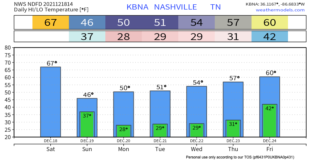
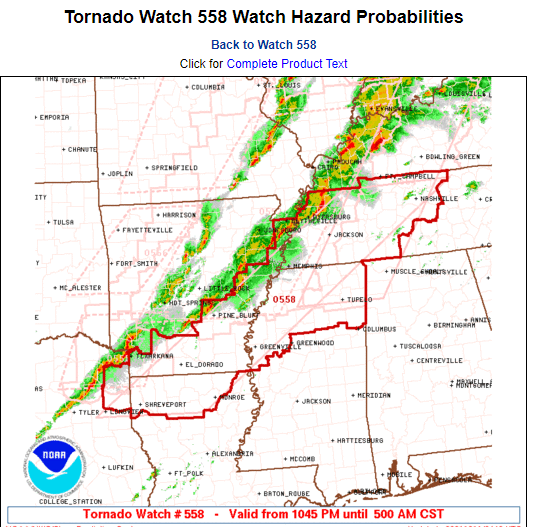
The sun is out but yeah, it’s chilly.
Tonight and overnight expect the coldest overnight lows of the season – definitely bring those plants in or cover them, and make sure pets are taken care of as these temps will drop below freezing.
The sun is out but yeah, it’s chilly.
Tonight and overnight expect the coldest overnight lows of the season – definitely bring those plants in or cover them, and make sure pets are taken care of as these temps will drop below freezing.
Showers don’t move out until after 9 PM.

Following the cold front, temps plummet. Monday’s high will be in the mid 40’s with the low hovering around freezing. Temps will climb heading into midweek, but it’ll still feel chilly.

Temperatures will get up to around 60 today thanks to a warm front that moved in last night. Tonight, lows will be in the lower 40s.

The HRRR (above) shows there will be no rain today. It will be mostly cloudy.
Tonight, overnight lows could dip back into freezing temps. Clear skies giving way to more clouds overnight.
We can expect a warmer Saturday and Sunday, but another cold front will be making its way through our area Sunday, bringing rain. GFS shows rain for most of the day. More specific timing as we get closer.
Rain is still lingering from a cold front that passed through this morning. No concerns at all for anything severe. We should clear out right around lunchtime. See HRRR below:

This cold front is living up to its name though. Yesterday’s high was 74, but today’s is only 55.
Warm today with temps creeping up to the mid 70’s and wind gusts up to 30 mph. A cold front passes through early tomorrow morning. HRRR has sprinkles in our counties starting around midnight with the bulk of the system starting around 2am. Heaviest rain is overnight. Leave a tad early tomorrow as the rain persists during the morning commute. Showers move out by 11am. No severe weather is tagging along.
A warm front that passed through this morning. Result: overcast and warmer. Highs today hover around 70. There’s a chance of a light sprinkler here and there, but the real rain comes late Wednesday night, probably Thursday.
Pretty normal for November today–highs around the mid 50s. No Tuesday morning freezing (mid 40s). We warm each day. We won’t freeze until after the next rain event.

ETA Wednesday night through Thursday morning. Nothing severe, but can’t rule out rumbles of thunder. No more than half an inch forecasted for us right now, maybe less, maybe much less. The latest Euro run hasn’t changed much since yesterday:
Temps won’t be as chilly as yesterday. The high will be in the upper 50’s. Definitely still jacket weather.
The HRRR shows a line of showers just missing us today. There is a chance the showers hold together and we get a little rain but if we do it’ll be brief, around lunchtime. Winds will be gusty, already 20+ MPH this morning at BNA, but not to Wind Advisory criteria (that’s 30+ MPH).


The HRRR below is showing no rain in Tennessee today. Skies will be mostly sunny with a high of 49 degrees. If you are going out today, it would be good to grab a jacket or coat.

Tomorrow will be similar to today; no rain. It will be warmer tomorrow with the high around 60 degrees.
You must be logged in to post a comment.