Clear Today, Rain Chance Saturday Night

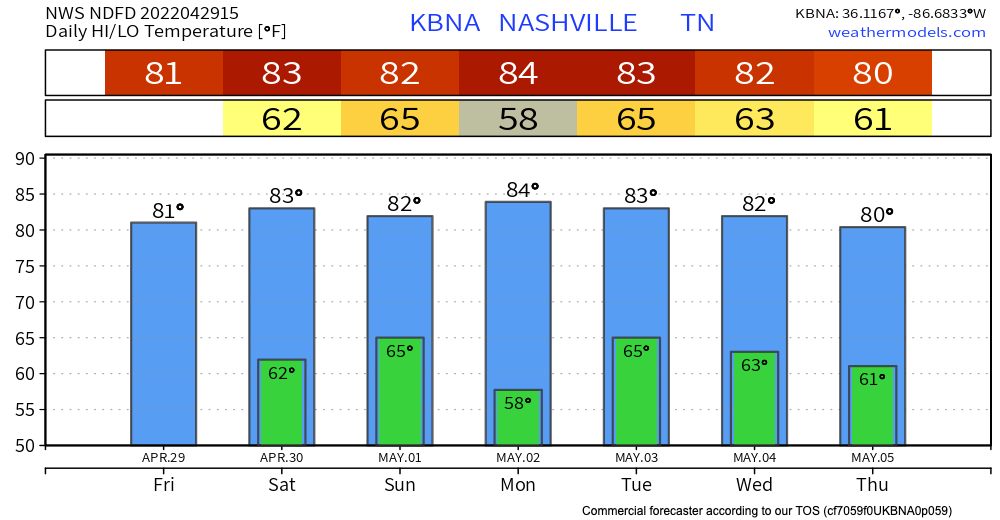
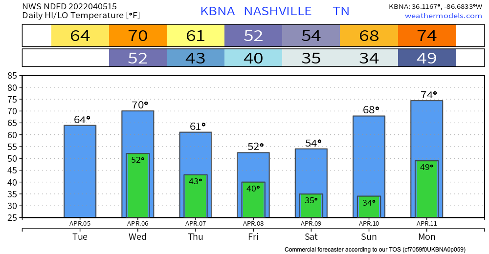
Friday and Saturday – enjoy these warm temps and rain-free skies. Highs are in the 80’s and lows in the 60’s AKA capital S Spring weather.

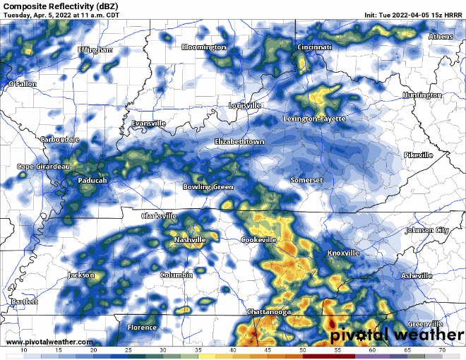
The next weather event we’re watching is Saturday overnight into Sunday. HRRR shows some spotty storms arriving around midnight and clearing out by 7am. This means your Saturday evening plans should be good to go, as well as your Sunday plans! read more

Cooler Temps Tonight; Unsettled Weather Coming

The cold front has moved past us, leaving us with much cooler temperatures this afternoon and evening. Temps drop into the lower 40s tonight. Maybe upper 30s in the outlying areas. Chilly air is back for a bit, but no freezing temperatures are in the forecast. read more

Warm Weekend!

We have an upper high hanging out that’s keeping us warm and dry this weekend! Temps will hit the lower 80s! Everybody say thank you upper high!

Next Week

Looking ahead to our next weather event Monday, we’ll have a cold front making its way through our area bringing cooler temps and some rain. The GFS shows us having a wet Monday. Keep in mind we’re a little far out to completely rely on the model’s timing/severity. read more

Possible Scattered Showers, then Warming Up!

Happy almost Friday! Showers have moved out, but it’s possible we might get a splash or two later.

Warm and sunny the rest of the weekend!

Our next weather event is shaping up to be Sunday night through Monday and even into Tuesday. Monday looks wet, but it’s a bit too far out to know the details yet. More to come in the coming blogs. read more

Showers Today, Storm Threat Tonight

Throughout today, we’re expecting to see some scattered showers. Some of these individual clouds could drop some heavy rain and wind. No need to cancel daytime or dinner plans, but carry an umbrella in case the rain scatters on you. read more

Chilly and Rainy Friday

We will continue to see scattered showers for the rest of the day. Some sleet and graupel has fallen in some part.

Some rumbles of thunder are possible with a few of these storms, but nothing to be concerned about. As temps drop, some of these showers could be a little winter-y, but this is mostly to our East read more

Rainy Day Today, Severe Threat Wednesday

The rainy morning we’ve been seeing so far is almost done – for now.

The HRRR shows this system moving out of our area between 4 and 5pm, and we’ll have a rain-free rest of our evening.

Wednesday

Tomorrow we’ll get round 2. HRRR shows this second system moving in around 7am. The main line will pass before lunchtime, but more pop-ups will be around for the remainder of the day. With these popups, some may be just light drizzle, others may be strong severe thunderstorms. Instability and shear are present, so these storms have the potential to be severe, and we cannot completely rule out tornadoes. read more

Severe Threat Wednesday

Today we’re going to warm up a bit from yesterday, with highs in the 70s.

Tomorrow, we are going to get WINDY. Gusts up to 45mph are possible all day, even before the thunderstorms move in. Today would be a great day to make sure any furniture, outdoor decorations, and garbage cans are all secured. read more

Isolated Showers Later

Today will be a little bit chilly, and these temps are going to stick around through the weekend. Temps will be close to freezing overnight.

Later tonight, we might see some light showers in our area. Nothing widespread, and nothing severe, the clouds are just sprinkling a little. Timing is around 9 p.m., and it will clear out around midnight. read more

Couple of Rounds of Storms Possible Friday, Maybe Severe

Today we’re expecting seasonal temps and a sunny day. It’s a go for all St Patty’s Day celebrations.

Starting tomorrow, we have another rain/storm chance, potentially two rounds. The HRRR shows round one of storms coming through around 8 a.m, and clearing out by noon. This timing may change as we get closer. read more