A strong cold front has been causing us some rain and thunderstorms today.
0.33″ fell late thig morning into the lunch hours at the official observation site at BNA.
More rain is coming, for most of us anyway.

A strong cold front has been causing us some rain and thunderstorms today.
0.33″ fell late thig morning into the lunch hours at the official observation site at BNA.
More rain is coming, for most of us anyway.

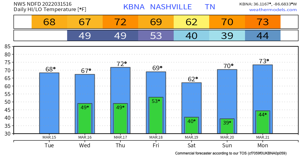
Happy hump day Middle Tennessee! Temps warm up to around 70 today. One thing we’re watching…Warm temps + dry + wind = fire weather concerns. However, with the rain we’ve had recently, we shouldn’t have any major issues. But, it’s something to keep in mind if you were planning to burn a brush pile today.
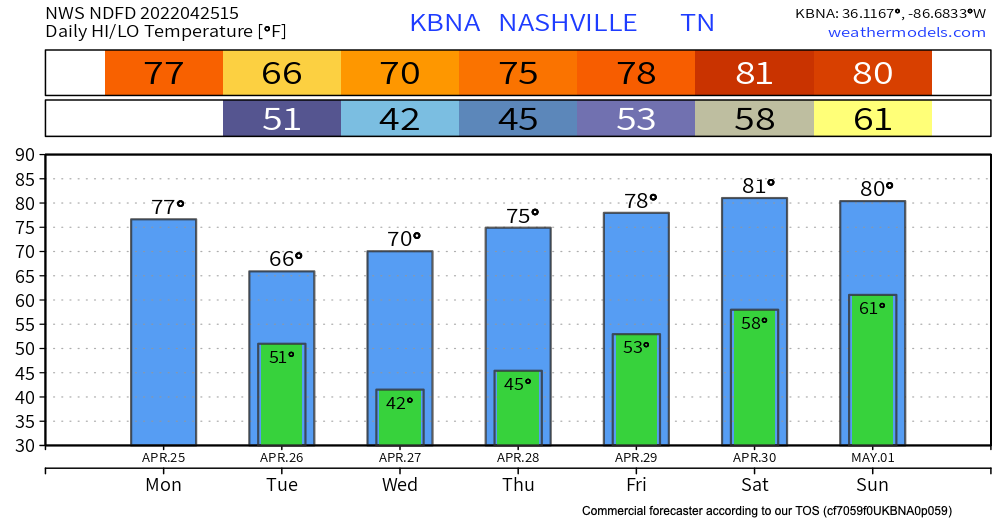
The cold front associated with yesterdays storms just passed through our area. This leaves us a little cooler for the rest of the week. Temps cool to the mid 60s by the holiday weekend.
We’re taking a short break from the rain. Today and most of tomorrow will be dry. Next chance for rain comes in Friday evening. GFS and Euro models scatter showers around town Friday evening after dinner time and continue through the overnight hours. The HRRR has a higher resolution take and shows the rain getting here after midnight Friday night:
Most, if not all of the rain has moved out for today. One flood advisory remains at press time, Whites Creek near Bordeaux. Many creeks are high right now, take extra caution if you live or work by one. Turn around don’t drown.
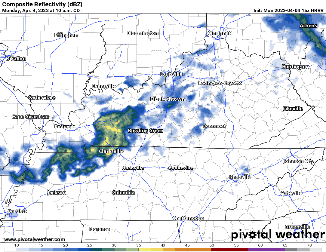
A wet, weather-filled week is ahead of us. Two rounds of potential severe weather are coming our way this week. Starting off with today:
Showers persist today with a small break in rain this afternoon for some of us. HRRR model below has strong storms coming into our area after sunset. These continue into the overnight hours and should be out of our area by Tuesday morning.
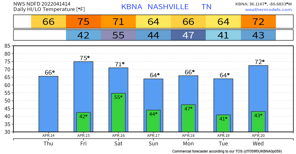
We are warming up nicely today to the low 70s. This is right around average for this time of year. These temps teeter totter in between the upper 60s and low 70s for the first half of the work week.
If you’ve been sneezing because of the yellow stuff on your car, rain is on its way. Some of us may see some light sprinkles throughout today associated with shortwave trough. No threats with these sprinkles and no need to cancel any plans.
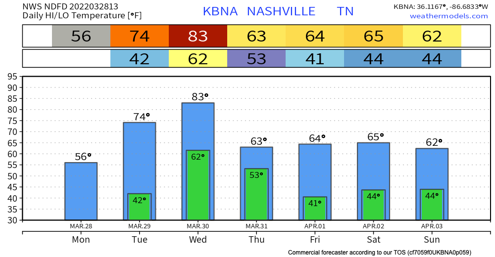
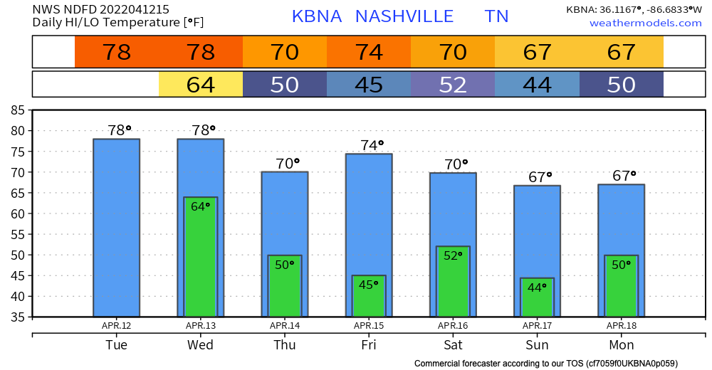
Happy Monday! Today will feel a lot like yesterday day with temps only reaching the mid 50s. Then temperatures into mid week, hitting the mid 70s Tuesday and low 80s Wednesday.
15-25 MPH sustained winds, with gusts 40 to 50 MPH hollering out of the south before the storms arrive later Wednesday.

Lotta rain coming in. Some thunderstorms. Severe risk is low, but not zero.
HRRR model below shows showers and storms coming in this evening. Main line is over our area around 9:00 pm. Stay weather aware this afternoon through evening time. These showers and storms should be out of the area by early Wednesday morning with lingering sprinkles up until 12pm Wednesday. HRRR through 6:00 am tomorrow:

Another beautiful spring day today. Low 70s and sunshine. Clouds increase throughout today ahead of the system that is affecting us tomorrow.
Low pressure sweeps across the southeast tomorrow. Severe weather is not a concern for our area, that concern stays south of us (the legitimate severe thunderstorm and tornado concern will sweep from TX tonight to LA overnight into MS to AL Tuesday). For us nonsevere thunder, downpours, and gusty winds < 30 mph will be what we get.
Low pressure sweeps across the gulf causing our area some showers overnight tonight. HRRR model below has showers coming in right after midnight. These continue until about lunch time Wednesday. Perhaps some sprinkles do hang around Wednesday afternoon. No threats are expected to come with this system.