Rain, Few Storms Sunday; Titans Gut Feels; Rain Monday; Fall Temps Next Week.

95° Today Ends String of Heat Records

This broke the old October 5 record, 92° set way back in 2018. (We tweeted a high of 94° earlier today, then we made it to 95° at 4:26 PM).

[T]oday was the 99th day of 90+ degree days. Yes, we’ll pull up just short of 100 90+ degree days and we also never got to 100 degrees on the mercury. I guess that’s little saving grace with all of the records we have broken in the last month. read more

We’re Relaunching! It’s Finally Gonna Rain! And Get Colder!!! T-Shirts & Merch!!!! (and other stuff).

LOGO. Same concept, better logo.

SHOP. To help support @NashSevereWx, we are selling shirts (choose supersoft or sturdy), a hat, and comfy hoodies with our logo. Limited supply. We’re not putting our logo on something you’ll hate. We got a great t-shirt team. Products will be simple, not obnoxious. We’re taking orders now, and will fill them in a few weeks. These shirts make @NashSevereWx ad free and pay our bills. NashvilleSevereWeather.com/shop. read more

Fall Officially Moves in this Weekend; Chance of RAIN Sun thru Mon(!!!); Drought Monitor Update

Summer is Still Here… For Now

Thursday: hot and dry… again. How hot? Well, we’ve already broken the 116 year old record for today, which was 92°. This graphic from the pre-dawn hours gave us a forecast high of 97°. NWS is now thinking 99° at BNA with even the possibility of….well, you know…

Dewpoints will be in the lower-60s. Not bad but still a little humid.

Cool, Hot, Then Fall Moves In

We finally drop below 90° Friday, though a ridge returns Saturday bringing us back into the 90s. Good news?

“However, that should be the last day of afternoon high temps 90 or above for the considerable future.” @NWS-Nashville read more

Summer Heat Today & Thursday, Cooler Friday, Real Cold Front (& Rain!) Late Sunday-Monday

Okay, this is unnecessary. The heat is STILL going strong.

Expect to hit into the upper 90°s for our high today. Dew points in the low to mid 60°s.

No rain chances until late weekend.

NWS-Nashville has more info:

Yesterday, new record high temps for Oct itself were established at the Nashville International Airport: 98 degrees and at the Crossville Airport: 91 degrees. Like I have done the last couple of mornings, broke out a climate section below with the “hot temp specifics”. Along with record high temps for a couple more days, the possiblity also of recored warmest low temp values being set tonight for certain locations across mid state region. Please, like previous days, continue heat safety precautions thru at least thru Thu afternoon, especially if you have to work or be outside for any extended periods of time. For additional information concerning NWS heat safety tips and resources, visit: weather.gov/safety/heat. read more

September 2019: Record Heat/Dry. October Relief?!?!

Another Hot, Dry Day

High temps will reach 96° Sunday (record high is 98° set back in 1953). Heat index 98°. Touch of humidity (not oppressive).

What else is new?

The HRRR model throws us widely scattered, brief showers, but I wouldn’t count on them.

This model has often (recently) predicted these showers in this high-pressure weather pattern. Rarely happens tho.

More Record Heat Ahead

“A strong upper level high pressure system will keep record-setting heat going through midweek, especially high temperatures. Afternoon heat index values will be in the upper 90s to around 100…” @NWS-Nashville read more

Heat to Last through the Weekend and into the Week

Record-Breaking Heat has Returned this Weekend

You know how it’s the last weekend of September? Well, it feels like the second weekend of July.

Editor’s Note:

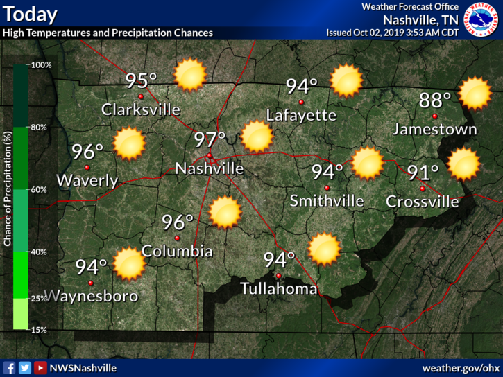
Highs today will approach the mid 90°s with dewpoints in the mid 60°s.

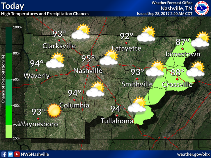
Rain chances are slim. The highlight of the ongoing state-wide drought has returned. The high pressure “cooker” is back.

I’m not happy about this, I’m sure many agree.

NWS-Nashville has something to say:

After record setting heat yesterday, this morning`s low temps will be around 15 degrees or more above normal and possibly record setting for warm overnight lows. Ugh. The main wx feature for this hot forecast period will be a strong upper level high setting up shop directly over the lower Mississippi and Tennessee Valleys. Guidance numbers continue to be much too low just like we saw during the last heatwave. NBM (National Blend of Models) looks best, but even those values may not be warm enough at times. Record highs are likely most days through at least Wednesday.

Same NWS-Nashville, same.

Looks like we have a few more days to deal with the summer.

And the Heat Continues into Sunday

The high pressure system will remain throughout the weekend. That means hot and humid conditions that are likely to break records.

So Sunday will be about the same.

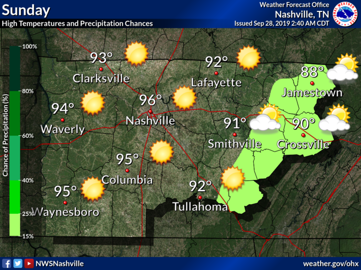
We could very well see heat index values into the low 100°s.

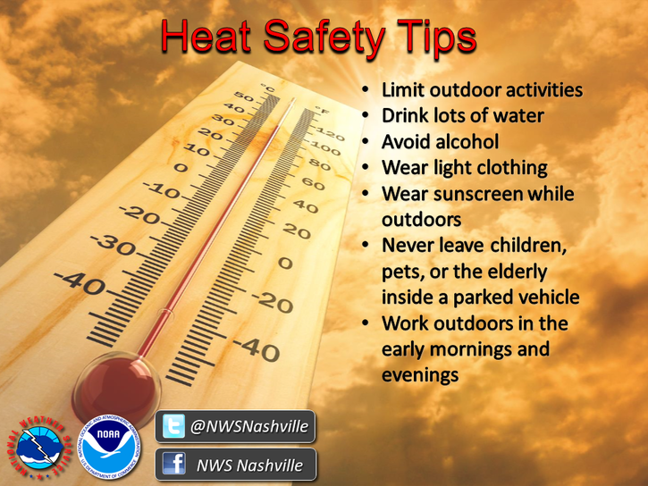
So be careful out there and stay hydrated.

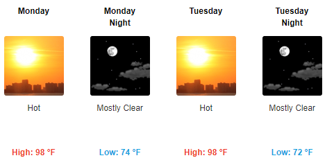
Update: The Heat is Still Here

As we move into the beginning of the week, the heat remains, with highs in the upper 90°s.

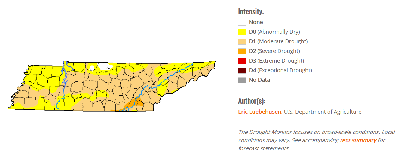
Still no rain in sight. Here’s the drought monitor for the state:

Remember, check back for updates as they come. Follow us on Twitter @NashSevereWx!