Warming Up, Little Bit of Rain Friday Night

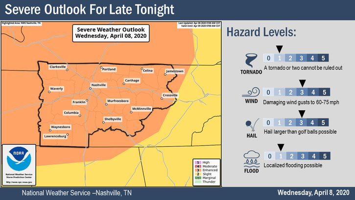
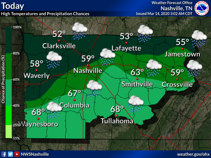
Warm Up after Subfreezing Temperatures

We hit 30°F before sunrise. Bit of a scare for those who have already planted their gardens. Temperatures are expected to rebound nicely afternoon. High around 60°F.

A high pressure system is in place to make sure it stays sunny. Lows tonight will dip back into the upper 30s. Some frost may still be possible in many spots, though another hard freeze is not expected.

Warming Trend Continues into Thursday

Thursday looks to be saved by the high pressure as well. Thursday is Day 2 of a multi-day warming trend. High for Thursday around 64°F.

No frost expected for Thursday night. Low will be in the mid 40°s. Still chilly for April, but plants and gardens should be okay.

The Next Shot of Rain

Friday will be the warmest day in this 7 day period. High of 73°F.

We are warming up thanks south/southwest winds. Winds Friday will be around 15 to 20 MPH, with gusts up to 25 MPH. The NAM3 illustrates those winds:

Our next rainmaker comes Friday night. Some showers and maybe an isolated thunderstorm or two. No severe weather is expected.

A slight chance of rain will linger Saturday and Saturday night. It won’t be much rain at all. Total rainfall over the next 7 days (through to Monday) is only around a quarter of an inch for our area.

Be sure to check back for updates to the forecast and follow us on Twitter for more @NashSevereWx!

Damaging Winds, Large Hail, and an Isolated Tornado Possible Late Tonight

Our severe weather risk has been upgraded and could very well be upgraded again later today by the Storm Prediction Center. We are looking at a damaging wind and large hail event for tonight through the early morning hours. A tornado is less likely, but possible.

Most of the day will be dry. We’ll warm up into the mid-80s. We could see a few isolated showers and storms this afternoon before the bulk of the event gets here. Those have a small potential to be severe but will not be the “main event.”

The main event is late tonight. Stay connected through the day for changes and updates. For now, here’s what we think:

Main Severe Weather Event Timing

A line of storms will stretch across I-24 and move southeast, arriving here between 11 PM and 2 AM. Timing may need adjustment as we move closer to the evening and models develop consensus.

Here is the HRRR beginning to show that line of storms moving in around 12 AM:

The NAM3 has the main line pushing through around 1 AM.

Threats

  • Damaging winds up to and in excess of 70 MPH
  • Large hail up to 2 inches in diameter (golf balls or bigger)
  • Isolated tornadoes embedded within the main line of thunderstorms
  • Frequent cloud to ground lightning
  • Brief, localized flooding from torrential rainfall

Damaging Winds

Watch the radar tonight for storms to be shaped like bows (not cute bow, bows from bows and arrows), there we find the strongest winds. These bows look like a closed parenthesis on radar. Do not want!

The probability of a damaging wind event happening within 25 miles of us (Davidson and Williamson Counties) is 30%.

The shaded area means there is a “10% or greater probability” of winds greater than 70 MPH. These winds can drop trees and damage, perhaps severely damage, mobile homes. 70 MPH winds are near hurricane strength. This is a low probability of high impact event.

Secure your trampoline. Wind may convert them to frisbees.

Large Hail

Hail size is difficult to see on radar, but we can know it’s falling through good radar interpretation. The line will pass over the radar site in Hopkinsville, KY, about an hour before it gets here, so we’ll have a good look at the storms before they get here. We hope to get reports of any hailfall from Clarksville.

Forecast data shows just about everything you need for big hail: dry air aloft, steep lapse rates at mid levels, decent enough midlayer shear.

The probability of hail the size of a quarter within 25 miles of us (Davidson and Williamson Counties) is 30%.

We’re in the shaded area for hail. This means there’s a “10% or greater probability” of hail the size of an egg.

Protect loved vehicles.

Tornado

Damaging winds and hail are more likely than tornadoes. SPC thinks our probability of a tornado within 25 miles of us is 5%. Low level winds should be perpendicular to the line (that’s not a good sign), but surface winds are relatively weak which limits tornado concerns. Also comforting is that models seem to think there will be a shallow “cap” near the surface, which (without boring you with too much meteorology) will make it difficult for the storm line to tap surface moisture. This should limit, but not eliminate, tornado concerns.

Tornadoes can spin up in a squall line or within storm clusters. These tornadoes can be difficult to issue timely tornado warnings on because the circulations are often brief/short-lived. So be sure you’re prepared to shelter before the warning is issued. These tornadoes are usually weak but can be strong, so they will require your attention tonight.

Other Thoughts & Considerations

  • Have multiple ways to get warnings. If you have a weather radio, turn it on and have it ready. Have your cell phone fully charged and ready to go, along with a charged battery bank if you have one.
  • Review and practice your family’s safety plan. Where do you go and how do you prepare if you are put under a Severe Thunderstorm Warning or Tornado Warning? Not sure? https://www.ready.gov/plan is an excellent source.
  • Treat any Severe Thunderstorm Warnings like you would a Tornado Warning. Straight line winds are serious and can cause a lot of damage. Take shelter if any warnings are issued for you.
  • Protect cars and other beloved outdoor belongings from large hail. In the unlikely event we get egg sized hail, it can break windows, so don’t be surprised.
  • Mobile homes may not be safe tonight. 70 MPH winds can demolish them.
  • Don’t try and drive in it. Rain will be torrential, with potential for brief localized flooding. The rain/wind/hail combo in the dark is a no-go for safe travel. Let it blow through, then get in your ride and travel to where you must travel.
  • These storms will be in and out. Once they pass by, you can sleep peacefully.

It is going to be a late night for us, but we will be right here with you through it all.

Clearing out Thursday

Much cooler and not as humid for Thursday. High around 65°F.

Lows early Friday and Saturday mornings are expected to dip into the upper 30°s. A few low lying areas may see frost.

Much Cooler Friday and the Weekend

Friday’s high will only be in the upper 50°s. Another low in the upper 30°s Friday night.

Rain comes back into the forecast on Saturday night, going into Sunday. There’s a severe threat for the Southeast Sunday, but right now it looks like we will be too far north to concern us. However, we could get more than 1″ of rain.

Be sure to follow us on Twitter @NashSevereWx for more information as the event unfolds tonight. Keep an eye on any updates that may come out later today. We’ll keep you posted.

Cloudy but Dry Weekend, Rain Returns Next Week

AM Showers Dissipate, Cloudy but Pleasant

We have a few light showers to our northwest. A sprinkle or two that may or may not reach us before noon. Other than that, expect clouds and a high near 75°F.

Cloudy for Sunday, Low Rain Chances

The warm trend continues. High temperature is about the same for Sunday. Chance of showers will linger but will be low.

A Look at Next Week

Monday looks to be a wet start to next week. This will be accompanied by an approaching warm front. High temperatures next week should begin to climb into the upper 70°s and possibly low 80°s.

Tuesday is still looking to be the best chance of rain.

In spite of weak upper ridging, Tuesday will give us our best opportunity for convection. Still, in the absence of any sharp features that would help focus some of this moisture, QPF`s associated with this system are relatively low. Model soundings do suggest modest amounts of instability, but probably not enough to produce more than isolated thunderstorms amongst more widespread showers.

NWS Nashville Forecast Discussion, 04/04/2020

Despite warm temperatures and model suggestions of instability, severe weather is not expected. The most we might see is a few isolated thunderstorms within the more widespread showers.

Remember to check back here for updates to the forecast and be sure to follow us on Twitter @NashSevereWx!

Saturday’s Severe Storm Risk Shifted West.

Drying out and Warming Up

It’s cloudy. We hope to see these clouds disappear by this afternoon. Right now, this is what satellite looks like.

You can see these low clouds hanging over us. If I could animate this, you would see these clouds beginning to erode to our east.

This is the most action we will see today. Disappearing clouds. High should be around 65°F but this could vary depending on cloud cover.

By Thursday, clouds will be long gone. Our high should get into the upper 70°s.

The warming continues into Friday. We could see highs approach the mid 80°s by Friday afternoon.

Next Shot of Showers and Thunderstorms

We are still looking at the possibility of thunderstorms on Saturday. But first, an update:

Yesterday, the Storm Prediction Center placed us within a 15% probability for severe weather for Saturday. Today that risk area shifted west of us. We will still get some rain, maybe storms, at some point Saturday or Sunday, but this is somewhat encouraging that the severe risk shifted west. We are still a few days out from Saturday, so this is subject to change.

Be sure to check back here for updates to the forecast and follow us on Twitter @NashSevereWx!

Rain Returns on Sunday, Another Chance at Storms on Tuesday

A Rain Free Saturday

A break from the rain gives us a quiet Saturday. We have a few clouds, no big deal.

It’s also a bit chilly today, along with that northeast wind. We know it is spring but keep that jacket nearby for now. The high will be around 55°F today. Our low tonight will dip into the upper 30°s.

This dry weather will be short lived as our next shot at rain is on its way.

Rain Returns for Sunday and Monday

Sunday will begin dry but that won’t last because the next rainmaker is coming.

This rain should start Sunday evening. The ETA is around 5 PM to 7 PM.

The rain will continue through the night and end early Monday morning. These are scattered showers and a few isolated thunderstorms. No severe weather is expected.

Here is the HRRR, showing the start of these showers as they move into the area. ETA between 6 PM and 7 PM.

And the NAM3, which can see through to Monday. Showers clear out early Monday. ETA between 5 PM and 6 PM.

Chance of Storms on Tuesday

We get another break from the rain before another system moves in on Tuesday.

NWS-Nashville:

There is at least some initial concern that great enough instability along with deep layer shear could be present across our area to support development of severe thunderstorms Tuesday afternoon into the Tuesday evening hours. Damaging winds appear to be the hazard to be most concerned about presently, but specific details concerning hazard types continuing to remain somewhat uncertain as of this time.

NWS Nashville, Forecast Discussion on 03/21/2020

The Storm Prediction Center also has our area under a 15% probability of severe thunderstorms.

We are still a few days out, so this can and will change as more information comes in.

It is a bit early for specific details at this time. We will be watching this closely in the days ahead.

Be sure to check back here for updates to the forecast and follow us on Twitter @NashSevereWx for more!

Rain Off and On Today, “On” Tonight, Nice Sunday, More Rain Next Week (Storms?).

Off and On Rain Today

At 9:07 AM a little rain was coming in.

Off and on rain during the day. Rain will be scattered all across Middle Tennessee. Tonight, around 8 PM (give or take a few hours), rain turns on.

A half inch to three-quarters of an inch of rain total. No severe weather.

All this is illustrated by the HRRR model, below.

The NAM3 model tells a similar story.

Weird Temp Difference

This afternoon, warmer temps move north then stop somewhere in Will Co or Nashville:

Here’s that model at 1 PM.

One temp doesn’t fit everyone. Colder north, warmer south.

Rain Moving Out Sunday, Coming Back Monday

Sunday’s nice, around 55°F,

Rain returns Monday. Temperatures will bump back into the lower 60°s before these showers become widespread.

A Look at the Week Ahead

Rain will be off and on through Thursday, but models are inconsistent so no one know exactly when it’ll be “on” vs “off.”

Thursday, storms may be ongoing in the southern Plains (TX, OK, KS). Models think some storms move into the southeast, and may impact us, Friday. Model resolution is poor at this range, and models disagree, so no reason for concern right now. But we need to watch it; it’s severe weather season.

Be sure to check back for updates to the forecast and if you haven’t already, check us out on Twitter @NashSevereWx!

Some Rain Today, Strong/Severe Storms Possible Thursday PM

Rain this Afternoon

Today’s atmosphere is stable and unsupportive of severe weather. As I’m writing this, all data indicates no instability which is key to making big storms. Other ingredients necessary to support severe weather are also missing today.

A storm complex is moving through West Tennessee and Arkansas this morning. Here it was at 9:30 AM.

Composite radar image taken at 9:30 AM, showing the MCS being mentioned.

This is called a MCS (Mesoscale Convective System – fancy word we use for a system of storms). It will move in our direction today and “get here” early to mid afternoon, but it will encounter our storm-unfriendly atmosphere and weaken substantially.

Below, the HRRR model predicts the MCS will fall apart as it moves into our area.

The HRRR is not the only model saying this. The NAM3 model also shows the MCS weakening as it moves toward us. We still may get some rain showers. Lightning on arrival looks unlikely. Winds may be gusty, but there is no concern for tornadoes today (Wednesday).

NWS-Nashville had this to say:

There is some suggestion that this MCS should erode as we get into the mid-to-late afternoon hours, so I’ve trended in that direction, but some leftover light showers will be possible across the south into the evening and overnight hours.

As with any MCS, they can create an environment ripe for strong, gusty winds, so if you live west of I-65, you will want to monitor the weather throughout today.

NWS Nashville Forecast Discussion, 7:55 AM on 03/11/2020

Maybe a few scattered showers tonight, fields may be wet.

Strong to Severe Storms Possible on Thursday

Thursday morning, a warm will lift north and cover us like a warm blanket. As that happens, a few showers, any maybe even a weak thunderstorm, will be possible, but there is no indication anything will be severe.

Severe storm potential begins as early as Thursday afternoon, but is more likely Thursday late-afternoon and night.

NWS-Nashville says:

  • A few storms could be strong or severe with damaging winds and large hail over northwest Middle TN. This risk area includes Nashville.
  • Cannot rule out an isolated tornado.
  • Total rain accumulations by Friday morning will be only around a half-inch to an inch, so no flooding concerns with this event

This is how the SPC breaks down our risks for tomorrow afternoon and evening.

Damaging winds are the most likely threat. We are in the yellow. This means a 15% chance of seeing winds of up to 58 MPH within 25 miles of us.

Next, the tornado threat. We are in the brown, indicating 5% probability of a tornado within 25 miles of anywhere inside the brown, us included.

Lastly, the hail threat. In the brown as well, 5% chance of seeing 1 inch hail or larger within 25 miles anyone in the brown, us included.

Editor’s Note: Sometimes 2% probabilities happen. They did last week. Use probabilities to estimate risk and remind yourself to keep checking for additional, more recent information which will be more specific, actionable, and clear. Models disagree how this event will unfold. Some models are concerning, others not so much. Stay connected. Things change fast (sometimes, they change for the better!).

Always be prepared, and have a way to get information and warnings as these storms move through. Secure loose objects and tarps for wind.

We know it is too soon. We have no reason to believe this will be a repeat of last week, but regardless…we have no reason not to believe it. Avoid recency bias, which says if it happened recently it will happen again. What happened last week doesn’t make what might happen Thursday more or less possible. But it sure feels different after the March 3 tornado. We will be here with you. We will be here for you. We are not going anywhere.

Friday and the Weekend

Showers early Friday, drying out by mid-afternoon. Cooler but still spring like with highs in the 60°s.

Models remains confused for the weekend, but it looks rainy.

Be sure to check back for updates as this forecast will change and evolve as more information is made available to us. Also, check out our Twitter @NashSevereWx if you haven’t already done so.

Cool and Pleasant, Light Rain Showers Return Monday

Rain Free Weekend

We started off cold, with lows below freezing in some areas.

This will melt away as our high approaches the mid 50°s. ENE wind will make it chilly today.

Sunny and no rain for both today or tomorrow. Sunday looks to be similar.

Highs reaching nicely into the mid 60°s on Sunday. Winds shifting out of the south.

Our lows Sunday night will fall to freezing again. This will be the last night of freezing temperatures through Wednesday.

Also reminder that DST starts Sunday, a great time to check those battery backups in your weather radios.

Light Rain Showers to Start the Week

And the rain returns Monday and Tuesday.

A few isolated thunderstorms are possible. No severe weather is expected.

Rain accumulations around 0.5 to 1 inch. No major flooding concerns either.

The rain will continue on and off Wednesday and Thursday, not much additional rainfall is expected. These are light showers. In total, around 1 to 1.5 inches by Friday.

As always, be sure to check back for updates to the forecast and remember to follow us on Twitter @NashSevereWx!

A few comments about the tornado, then Hunter delivers the forecast.

Editor’s Note: You’ve poured love, encouragement, and support into @NashSevereWx for years, but never like we’ve felt in the past 36 hours. We love you guys, we love weather, we hate tornadoes, we hate the lost life, injuries, destruction.

Thank you for your kind words on Twitter and on Patreon and Paypal, for sharing your stories, we need to read them. I don’t know what to say or do to properly acknowledge them. Our response to your overwhelming financial support feels inadequate. I can only thank you.

I’m having post-event stress. I didn’t know it was a thing, but it is. Every “thank you” you’ve sent is a blessing. I’m processing all this . . . slowly. I’m having emotional swings. I’ve been told by broadcasters and NWS people who’ve been through this emotional swings are natural, isolating yourself is the worst thing to do, give yourself time to process. This was a nighttime tornado, through the heart of our community, with EF-2 and EF-3 damage. I have 100 things to say about this event, from the meteorology, to the warning process, to the storm itself, to everything in between, and there will be time for that. For now:

If you’re feeling anxiety, stress, etc., it’s normal, you’re not alone, there is help. Not all stress is the same. I was on the phone yesterday seeking counseling to deal with the stress of being a voice people turn to, yet watching destruction happen in real time. I’ve stood in damage of Katrina (I went to high school in Gulfport, MS). I’ve been on tornado surveys. I’ve never been a tornado victim, but I had one hit the house behind us (thankfully the weakest tornado ever) while I was not at home, but my family was. Your story is unique, the stress real no matter how you were impacted. You aren’t too tough to get help:

Helping helps. There are ways to plug in.

@NashSevereWx will keep going. Spring severe storm season just started. We aren’t going anywhere. We will review this event, find out what we can do to get better, to be better.

Show grace, empathy, and compassion to each other. Nashville has done that before, we will do it again. –David.

Here’s Hunter’s blog:


Mostly Dry Wednesday

Afternoon high of 65°F today, a chance of rain to our south. We expect to stay dry; only a remote chance of a shower around/south of I-840 later today.

Maybe a Little Rain Thursday

High around 60°F for Thursday.

Not much rain at all really – around a hundredth to up to a tenth of an inch is in the forecast, but it may just be cloudy.

The HRRR model shows a warm front hanging to our south and triggering rain, the rain sticking around northern Mississippi/Alabama/Georgia. It thinks no rain for us Thursday.

The NAM3 model thinks the rain will be a bit further north, but not by much. If this model is right, maybe a stray shower or two with this model’s eyes.

NWS Nashville:

There is no thunderstorm potential which is good for clean up efforts and storm surveys that will need to continue across Middle TN. It also looks like any heavy rainfall will stay south. [Rainfall] amounts today through tomorrow will be light ranging from a hundredth or so across the north to a couple of tenths across the south.

NWS Nashville, Forecast Discussion – 03/04/20

A Much Needed Break

We finally clear out. Highs in the 50°s, lows in the 30°s.

This will be great weather for clean up efforts. Go out and share the love, find out ways you can help if you can!

Be sure to check back to updates to our blogs as the forecast evolves and check us out on Twitter @NashSevereWx!

Light Rain Off/On Today, Possible No-Consequence Flurries Tonight, Rinse and Repeat for Friday

Rain Today, No Worries Flurries Tonight

Rain Rain, Go Away.

It’s not going away. It’s rainy season.

Afternoon high today 44°F, cooler thanks to cloud cover. Rain chances increase tonight. It will also be a bit windy, with gusts as high as 20 MPH. Chilly.

Rainfall will drip from the sky, so modest totals: less or around a tenth of an inch possible.

Inconsequential flurries possible tonight. No impacts for us, maybe a grassy dusting around higher elevations.

Below is the HRRR model showing light rain scattered this afternoon, transitioning to no worries flurries tonight.

The NAM3 model shows the same thing: off and on light afternoon rain today, then no worries flurries tonight, clearing after midnight.

Low impact snow possible on the plateau. You may hear about it on the local news because local news covers the plateau. We are not the plateau. We are far, far away from the plateau, so says your geography teacher (points to the plateau in yellowy orange):

Drying Out Thursday

Temps nose dive Thursday morning. Add the wind and it’ll feel 20F right around sunrise.

High 44°F Thursday afternoon . . . and sunny.

We are unsure what those yellow things are.

Here we go again . . .

Thursday night the next system moves in. Off and on rain possible again Friday (mostly “off”). This is a “clipper system” with low rain totals, and again, maybe flurries flying around Friday night but no accumulation. Any wintry precip will splat and melt on the warmer-than-freezing earth.

The Weekend and a Note About Next Week.

The weekend looks rainless after the late Friday night precip ends. Sunday looks especially nice when the high hits 61F.

Saturday, come on out to Trevecca.

Rain returns Monday through Wednesday. Unlike February 2020 weather systems featuring only rain, March brings warmer, more buoyant airmasses to Middle Tennessee, announcing the beginning of severe storm season. The Resources tab on our home page has severe weather tips for the uninitiated, or those just looking for more information. Basics. Storm Anxiety Management.