

LOGO. Same concept, better logo.
SHOP. To help support @NashSevereWx, we are selling shirts (choose supersoft or sturdy), a hat, and comfy hoodies with our logo. Limited supply. We’re not putting our logo on something you’ll hate. We got a great t-shirt team. Products will be simple, not obnoxious. We’re taking orders now, and will fill them in a few weeks. These shirts make @NashSevereWx ad free and pay our bills. NashvilleSevereWeather.com/shop.
WEBSITE. Same address. New layout. Loads faster. Works great on mobile. Has our Twitter stream. Displays official hourly temp and condition observations (no crap apps saying “tornado” when it’s not even raining). Will host YouTube Live severe/winter videos. Take a look at one of our 9 community supported/hosted cameras looking outside before you get out of bed.
YOUTUBE LIVE. 889,000+ of you have watched our live forecast, severe, flooding, and tornado warning coverage on Periscope. We’re moving this to YouTube Live. You won’t have to be on Twitter to watch. Subscribe to our YouTube Channel to get notifications when we go live or post a video. Don’t worry Twitter users, YouTube Live works great with Twitter.
FORECAST DETAILS & UNCERTAINTIES. Weather forecasting is super complex. It’s controlled by an infinite number of constantly changing variables. Get details, uncertainties, ranges, ETAs, on our website and through our Twitter stream. Hear from a person, not an unfeeling robot feeding questionable model data your app. David went to the National Weather Association conference and returned with a notebook full of communication ideas. He’s banging the drum about improving our writing and messaging. He won’t shut up about his 20+ page writing/style guide. Expect GIFs and illustrations galore, and a little humor. Warning: humor may not be funny.
TWITTER. The same. But, we’re always learning. Working to get better.
MISSION. The same. Deliver the best weather information for Nashville and Williamson County, by locals, for everyone. No ads.
So Much Cooler Today
A cold front came through last night. It was, like the Arizona Cardinals, dry and weak. High 85°. Nice north breeze. No rain. Tonight super comfortable as lows drop into the 60°s. Maybe a jacket for those who hate being chilly. Hold off on pumpkin spice latte because . . .
One More 90°+ Saturday
If we make 90° . . .
that will make 99 days this year of 90° or more. The record for October 5 in Nashville is 92° which was set just last year.
NWS-Nashville
This would add to the record of most 90° days in a calendar year, set this year.
No Saturday rain, plus dry dewpoints. At least it won’t be humid.
Speaking of dry, the drought is severe in Will Co, moderate in most of Nashville:
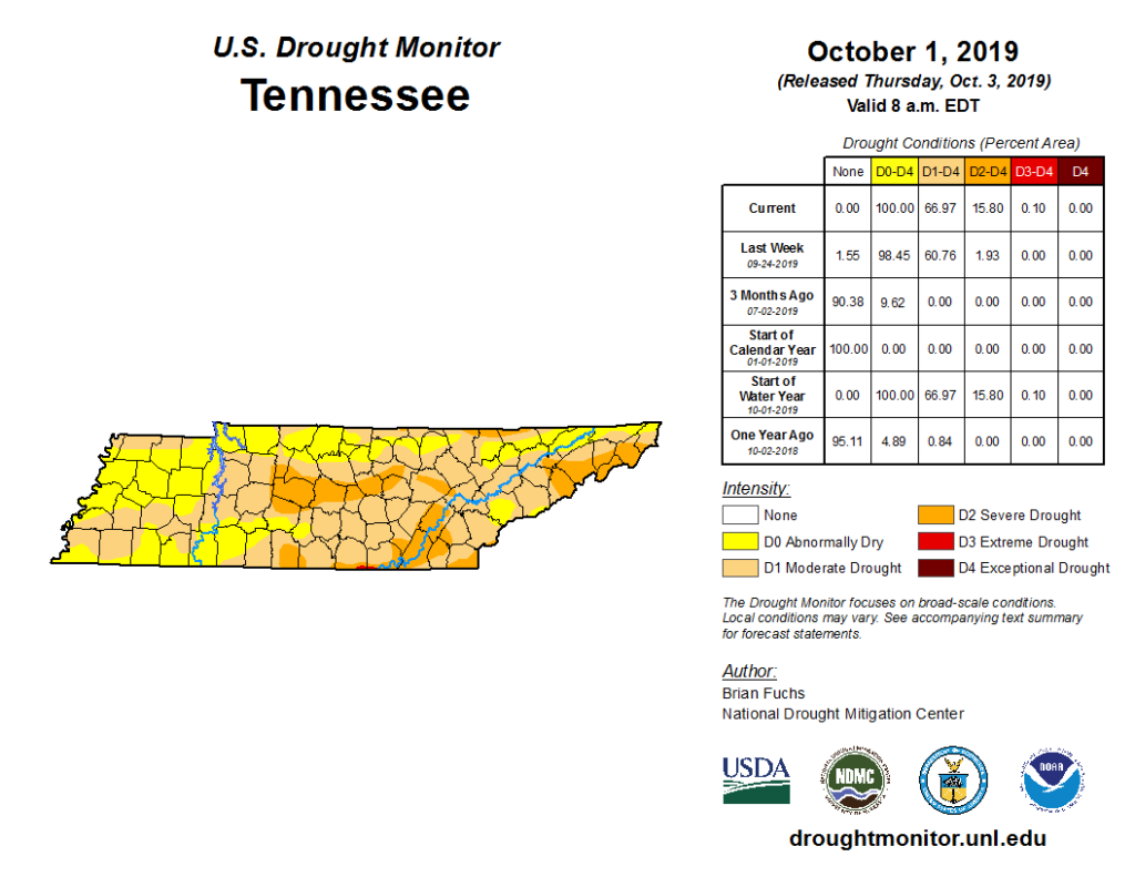
We need rain, and it’s coming.
Rain Possible for Titans/Bills Game, Cooler Temps Begin
We may see rain begin early Sunday morning but that’s unlikely and even if it happened, they should be light and widely scattered.
A more organized rain event starts sometime after noon Sunday. Humidity will soar again so you’ll want rain gear, not a winter rain jacket. Rain chances increase through the day as a cold front shoves a soaking rain event through Middle Tennessee.
Weather models aren’t sure exactly when the rain will start. The Euro thinks it’ll be more of a late Sunday afternoon/evening event, and at this range I don’t like to contradict the Euro. The NAM3 model isn’t great but it too has rain delaying until after the Titans game. Only the GFS has rain arriving during the game. Hard to say, and I think this forecast will need more work tomorrow, but for now I think probably no rain for the game, but check back tomorrow when higher resolution models get in range of this event.
Complicating this forecast is the chance of thunderstorms. There should be just enough instability to set off a few storms later Sunday, but they should be widely scattered and weak. I don’t want to rule out a lightning delay Sunday but right now that looks unlikely. Better chance for storms looks to be west of us.
Most of the rain will fall Sunday night through the first half of Monday. Some models predict 3″, but that’s outlier data, the most reliable has about 1.5″ to 2″, again, most of that falling Monday. Monday should be a wash out. Expect a clear out by Monday night, then…
The sweet relief of Fall temps!
Watch the temp settle closer to seasonal normals through mid-October.
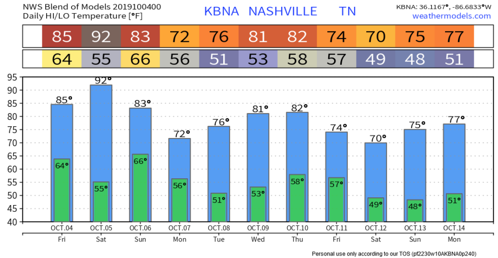
This is from the National Blend of Models, so expect tweaks a few degrees up or down. Some temps are still above “normal” for October but after this historic run of 90°s, this is the cold front we’ve been waiting for. Even some 40°s in there.
No good rain signals for next week, but, as always, data is inconclusive this far out.
Thanks for reading! We publish a new one of these every day, and update and supplement this information on Twitter all day, every day, as needed.

Categories: Forecast Blogs (Legacy)