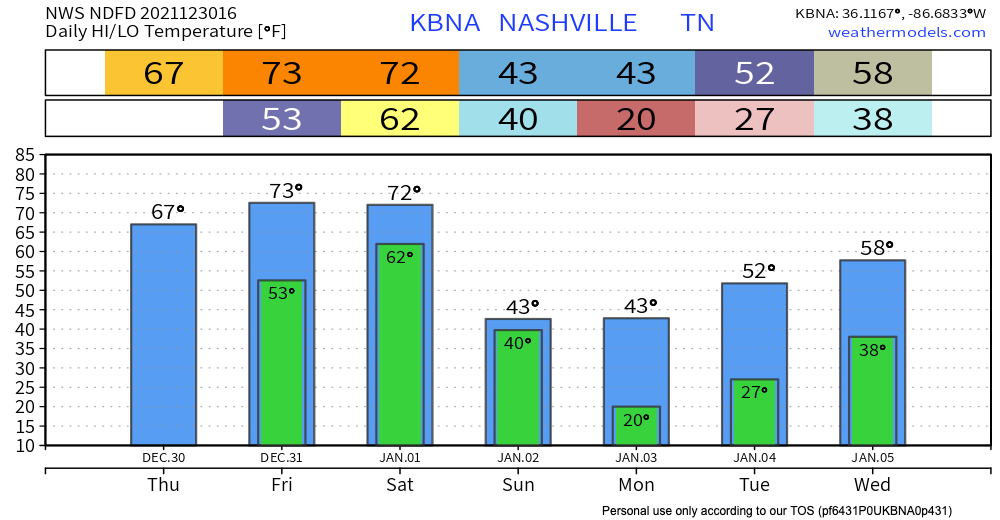
Snow Forecast Was For Less Than 1″, Now 1″ to 2″

Snow is coming.

The latest HRRR model run delivers snow earlier than the earlier 4-6 PM timeline. It thinks the wintry stuff could be here as early as 1 or 2 PM. See below:

This image has an empty alt attribute; its file name is floop-hrrr-2022010215.ref1km_ptype.us_state_ky_tn.gif

Expect the first hour or so of snow to melt on contact. The ground is very warm. But heavy snowfall rates should supercool everything, and eventually allow for the snow to stick to all surfaces. NWS-Nashville increased snow totals. read more

Snow Forecast Up from < 1", Now 1" to 2"

Snow is coming.

The latest HRRR model run delivers snow earlier than the earlier 4-6 PM timeline. It thinks the wintry stuff could be here as early as 1 or 2 PM. See below:

Expect the first hour or so of snow to melt on contact. The ground is very warm. But heavy snowfall rates should supercool everything, and eventually allow for the snow to stick to all surfaces. NWS-Nashville increased snow totals. read more

Sunday Snow Because Why Not

NEW YEAR’S DAY RECAP

Instability (not enough) – shear (way too much) combo was off today. Storms rotated and we had cause for the one tornado warning in west Williamson County, but by the time that storm got to the Will Co line it lost concerning tight rotation. We think Ned’s cap hung on just long to keep storms from exploding over 20kft, so we escaped New Year’s Day unscathed. read more

Severe Storms and Heavy Rain Possible Through Saturday Night

This morning we’ll be seeing some scattered showers around the area, which should clear out before lunch time.

Later into this evening, some heavier storms will make their way through. The HRRR currently has the rain moving in around 8pm and sticking around through that New Years toast. This unfortunately means outdoor parties are a no-go. Probably going to be hard to shoot fireworks in the pouring rain. read more

NYE: Rain, Severe Storms? NYD: Rain, Severe Storms? Titans Game: Very Cold, Rogue Flakes Splat Melt

This is a complicated forecast that we make easy lol. Let me start off saying we’re relying on the HRRR model. I point this out because there are so many Somewhat Different Ideas from other weather models about Friday and Saturday. Were we to talk about all those that would make this weather briefing more annoying than it already is. I say that to ask you to please check back in the morning because timing and hazards may change, and I think the data might give you a clearer picture of what’ll be incoming. Saturday looks worse than Friday, generally speaking. I’m hoping this will at least help you plan your weekend. read more