Not much change to the forecast for today. More cloud coverage throughout the day plus some scattered sprinklers. Timing: this afternoon. Cooler and dry tomorrow with highs in the mid 40s. Look for wind chills to hang out below 40.

Not much change to the forecast for today. More cloud coverage throughout the day plus some scattered sprinklers. Timing: this afternoon. Cooler and dry tomorrow with highs in the mid 40s. Look for wind chills to hang out below 40.
A bit warmer today than yesterday… highs generally 5-10 degrees higher. Staying dry until at least tomorrow.
Overcast skies and maybe rain for some folks tomorrow. Likely just sprinkles; nothing to write home about. A slight cool off starting tomorrow ahead of a possible winter weather event this weekend.
Normal January temps are really sticking. Today and tomorrow will stay dry and cool with overnight lows dancing around the freezing mark.
Our area could see some showers Thursday. Euro model below shows some of us getting sprinkles in the afternoon time. GFS has any precipitation staying clear of our area. If this system lingers and ends up in our area later that night, a flurry may be in the mix. Chances aren’t high, so for now expect some sprinkles.
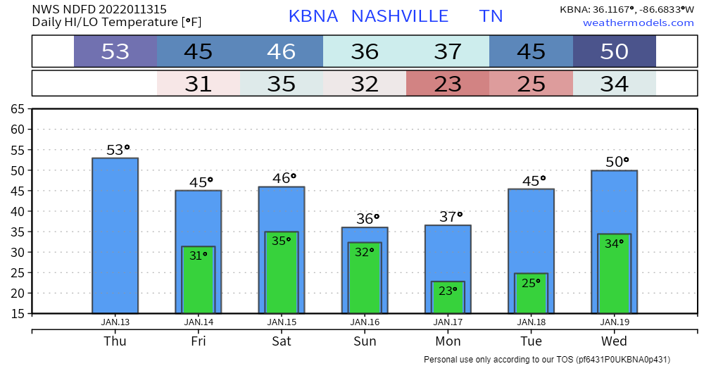
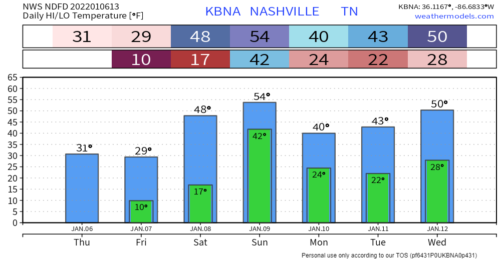
Not much weather going on the next couple days except sunny skies and right around average temperatures. High temps stay in the mid 40’s eventually getting up to the low 50’s by Wednesday and Thursday.
HEAVY RAIN
We’re starting off our Sunday with some rain. HRRR model:
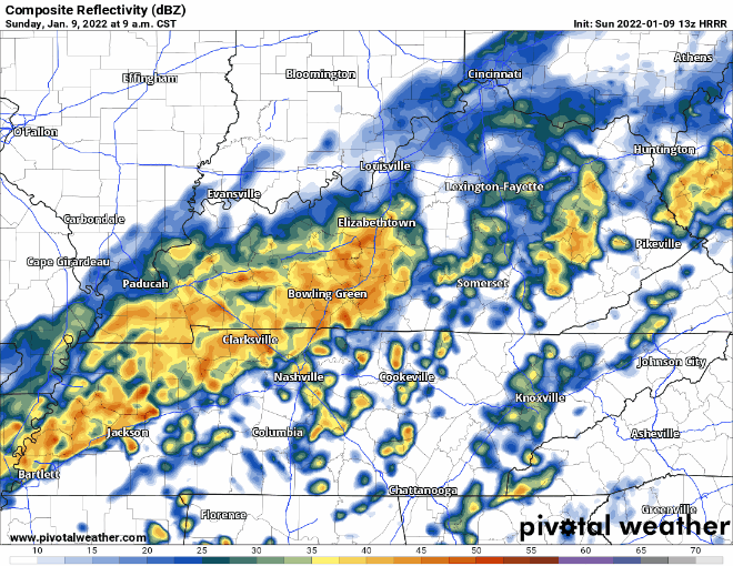
We are not expecting anything severe, but you might see some heavier rain or hear some rumbles of thunder as this cold front moves in. The biggest threat? Localized flooding, but this is a low probability hazard.
PSA:
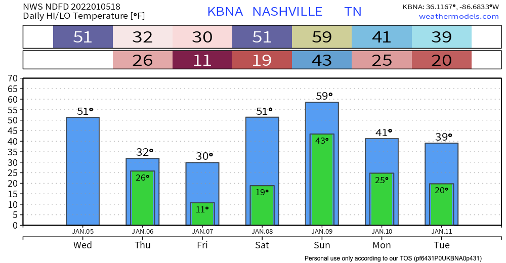
Temperatures will climb above 32 degrees at around 10 or 11 AM for the first time in a few days, allowing for some serious melting to begin, aided by the sun. It will take a while for all the ice and snow to melt. Melting occurs at different rates so there may still be slick spots, but today will be a dramatic improvement.
After yesterday’s record breaking snow, last nights extreme cold, and today’s below freezing temps, you can expect the snow to stick around today. Unless your car has ice skates instead of wheels, AVOID DRIVING IF POSSIBLE!! The roads are still very dangerous and icy. If you absolutely have to drive, make sure to go very slow and leave plenty of room between you and other cars. Don’t make sudden movements. Also be sure to bring extra warm clothes, food and water in case of emergency.
Our counties are currently under a Winter Storm Warning (in effect until 8pm tonight). According to the NWS:
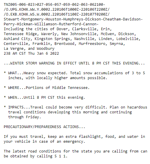
Can expect 3 to 5+ inches of accumulation… higher amounts could be seen locally. Let it be known that this is an all snow event. None of the freezing rain/sleet. Seeing pretty quick accumulation from flurries already.
Last month seemed like never ending severe weather. This month seems like never ending winter weather.
Today’s weather is pretty plain and simple. Slightly warmer temps, a little breezy, and no rain. Now on to the fun stuff.
Put very scientifically by NWS-Nashville: “Yep, looks like old man winter will be taking another swing at the mid state on Thursday.”
Middle Tennessee, in general, can expect this:
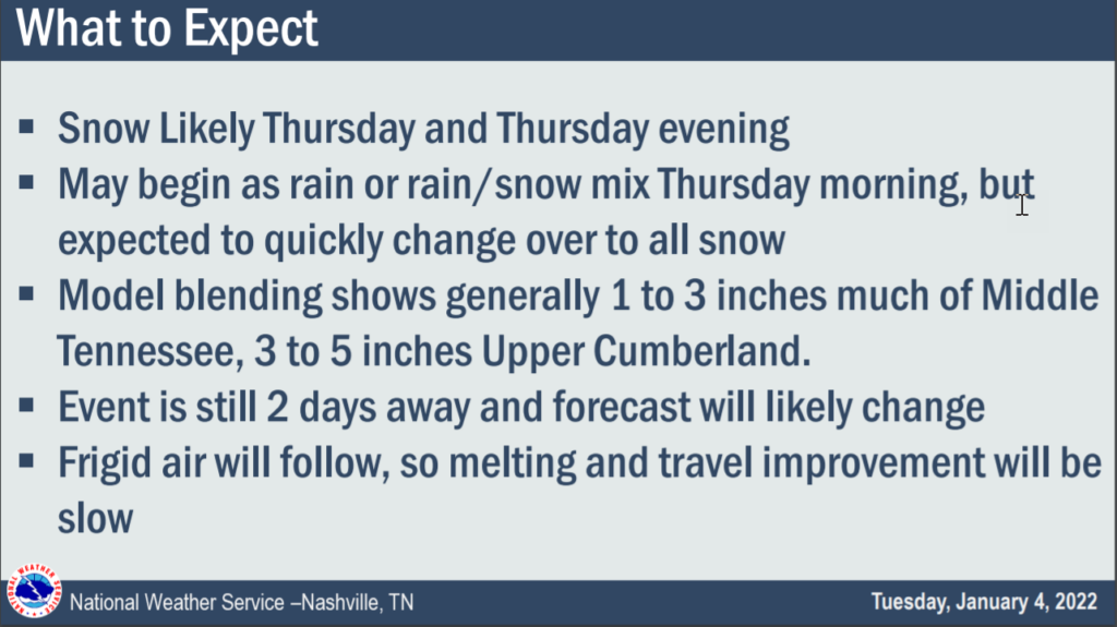
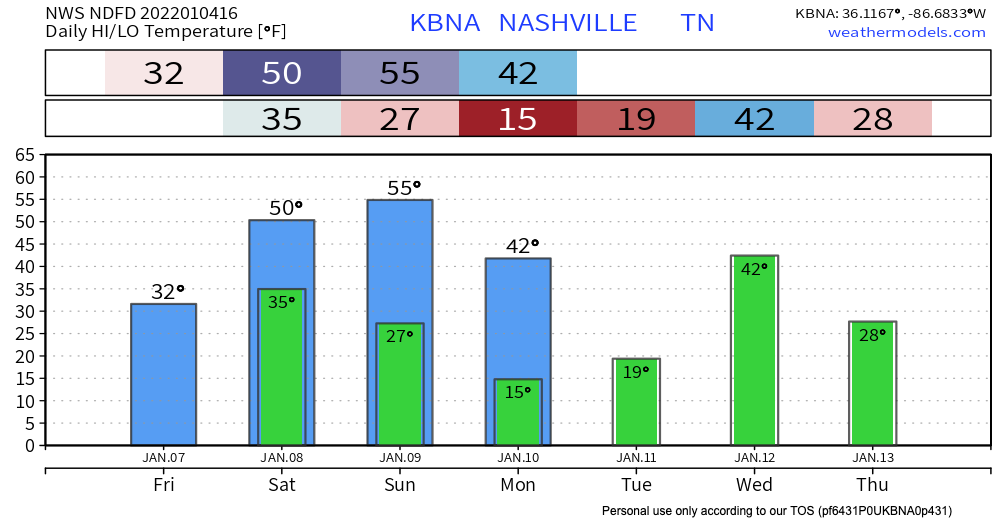
Timing remains iffy right now because we only have the lower resolution global models. Those models are the GFS and Euro. Both show a big blue blob (snow) moving through starting Thursday around 9 AM and lasting into early evening Thursday. Again, timing does not appear at all solid. Remember the above slide that says “Event is still 2 days away and forecast will likely change.” We will update you on changes on Twitter and in future blogs, as needed.
You must be logged in to post a comment.