
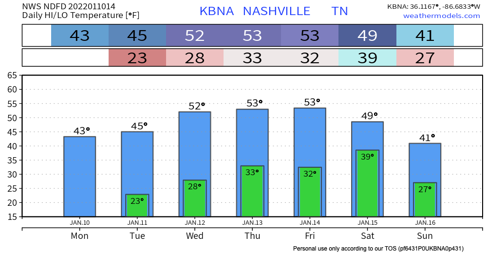
Not much weather going on the next couple days except sunny skies and right around average temperatures. High temps stay in the mid 40’s eventually getting up to the low 50’s by Wednesday and Thursday.
Overnight tonight will be under that hard freeze mark (28 deg). Remember to protect any of your P’s: people, pets, plants and pipes. Overnight Tuesday temps are still below freezing. Lows get to right around that freezing mark by the end of the work week.
High pressure sits over our area for the next couple days. We’re staying dry until the start of the weekend.
Next Weather-Maker: Friday into Saturday
A cold front is set to pass through our area Saturday bringing showers Friday night. These should be out of our area by Saturday night. As of now, these are not looking to bring any severe weather.
NWS mentioned in today’s discussion that a flurry may be in the mix Saturday as the cold air is ushered in. GFS shows a tiny bit of the “s word” coming into our area. The probability for it is low. Models are really nowhere, with each run they produce a very different idea.

Quick References:
Weather changes constantly.
Follow @NashSevereWx on Twitter for any changes to this forecast.
Live coverage during tornado and severe thunderstorm warnings:
Look good.
Support the mission.
We are 100% community supported. No ads. No subscription fees. Keep it free for everyone.
Categories: Forecast Blogs (Legacy)