Another nice day ongoing. Not too hot and dewpoints only in the mid 50s. Good day to take your lunch break outside.
Thursday our temperatures will slowly start to climb. Could be the start of a prolonged stretch of 90°+ days.

Another nice day ongoing. Not too hot and dewpoints only in the mid 50s. Good day to take your lunch break outside.
Thursday our temperatures will slowly start to climb. Could be the start of a prolonged stretch of 90°+ days.
Today and Wednesday will be the days to mow the yard and get outside. Highs in the low to mid 80s, tolerable humidity and dry.
Thursday a more summer-like pattern returns. High temps near 90° with popup showers/storms (the ole’ Wattery) possible in the afternoon and evening.
Another fairly nice day. Highs near 90°, although dewpoints will cooperate enough to where the heat index will not differ much, if at all, from the actual air temperature. Plenty of sun, no rain expected.
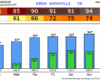
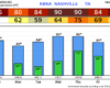
Although yesterday’s system did not bring as much rain as expected (we are still playing catch up, BNA is still 7.79″ behind for the year), we’ll take getting away with no severe or flooding.
Forecast remains on track.
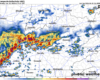
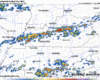
Scattered storms this afternoon will carry the threat of heavy rain, lightning, along with some strong winds.
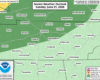
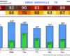
The Storm Prediction Center still has us outlooked with a 5% chance of damaging straight-line winds within 25 miles. We are not included in any probabilities for hail or tornadoes.
Today will be dry, but it certainly won’t feel as good as the past two days. Highs will get up into the low 90s, along with dewpoints in the mid 60s. The only factor that will be helping us will be gusts up to 25mph this afternoon and evening, which may help it feel a tad better.
Before we get into Thursday’s business, we do have another beautiful day in store.
A tad warmer than yesterday, with highs in the mid 80s, but dewpoints remain comfortable in the mid 50s. Another day to get outside or catch up on any yard work that needs to be done.
Hard to get nicer weather in the middle of June. Today and Tuesday will both have below-average temperatures paired with dewpoints in the upper 40s to mid 50s.

Plenty of sun and dry. Make any excuse you can to get outside.
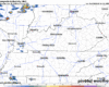
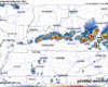
As of 1:15p, there’s a line of showers/storms just off to our west. We’ll be watching how that behaves, and any potential development behind it.
The Storm Prediction Center has our counties outlooked with a 5% chance of damaging straight-line winds within 25 miles. We are not included in any probabilities for hail or tornadoes. Although I reckon it’s feasible a strong storm could produce some sub-severe sized hail.
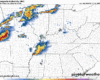
There is a low-end, conditional threat of damaging straight-line winds later this evening and into the overnight hours.
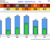
The Storm Prediction Cetner has us outlooked with a 5% chance of damaging straight-line winds within 25 miles. We are not included in any probabilities for hail or tornadoes.