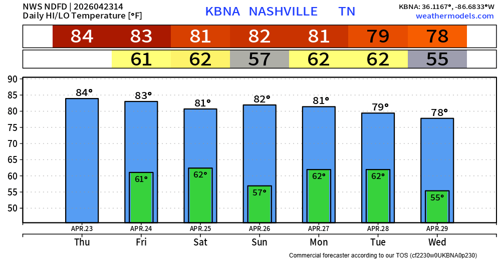
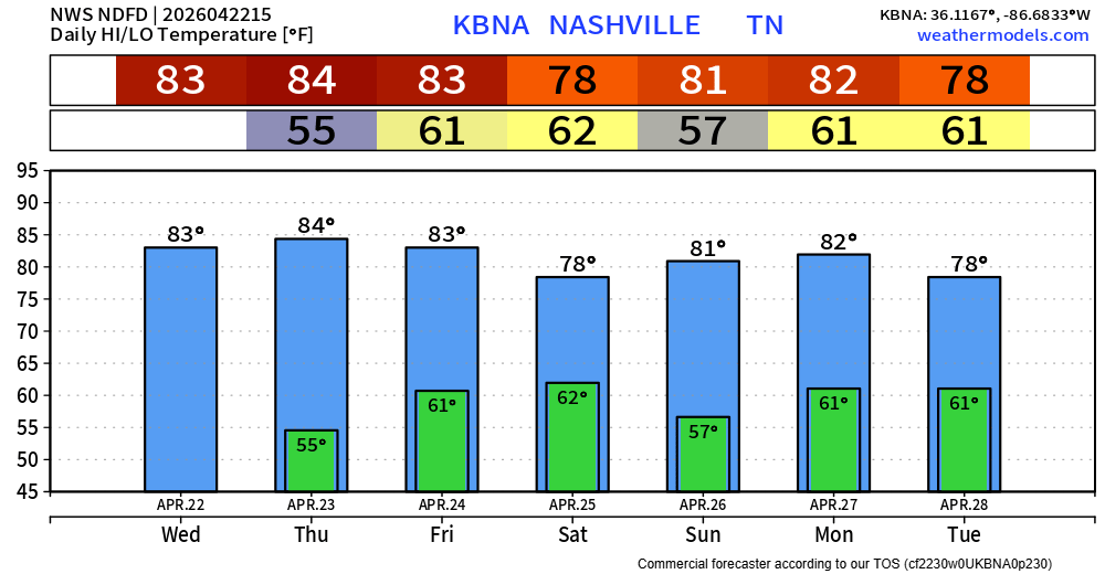
Headlines:
- 20-25° below average early next week…
- Rainy Friday PM/Saturday AM
Main highlight of the upcoming forecast will be the brutally cold temperatures arriving early next week. ‘
“As we move into next week, models continue to favor another very cold week with ensembles showing temperatures as much as 25 degrees below normal.” – NWS Nashville AFD
Tonight, Tuesday night, and Wednesday night – low temps will all bottom out around 20°. Prepare to bundle up for the bus stop, commute to work/school.
Temps will slowly warm up throughout the week, getting back into the 50s by Friday and Saturday.
Leave a Reply
You must be logged in to post a comment.
Temperatures have climbed all the way into the low to mid 40s, which has done a number on snowmen.
Some shady areas are stubborn and there could still be some slick spots on roads. Temperatures will dip below freezing again tonight, and while most roads are bone-dry, a few spots of black ice are possible Monday AM.
Leave a Reply
You must be logged in to post a comment.
If you are going outand about, please clear the snow off the top of your vehicle.
Please don’t let this be you or someone else.
With temperatures above freezing and the sun out, some melting is ongoing today. Good news for the roads, bad news for local snowmen.
Leave a Reply
You must be logged in to post a comment.
Well, it’s snowing.
Our Winter Storm Warning is set to expire at 9p tonight.
“Additional snow and sleet accumulations between 1 and 3 inches, as well as a light glaze from ice south of I-40…”
Leave a Reply
You must be logged in to post a comment.
There’s been a few tweaks in the details for our upcoming snow tomorrow, but the overall forecast remains on track.
Headlines:
- We’ll be under a Winter Storm Warning starting at 3a Friday
- 6-8″ of snow is most likely, maybe a little more, maybe a little less
- Road conditions will quickly deteriorate starting Friday morning
- Travel impacts will last until at least Saturday
Data can still change! Stay tuned for the latest updates on all of our socials. We’ll also be hosting a YouTube Live at 8p tonight to answer all your questions, and to hopefully make some decent jokes.
Leave a Reply
You must be logged in to post a comment.
As we continue to get closer to the event, some details are being finetuned, but overall, the forecast is on track.
Headlines:
- We are now under a Winter Storm Warning for most of Friday
- 3-6″ of snow is expected, with 4-6″ most likely for us.
- Travel conditions likely to quickly deteriorate starting Friday morning, and stay hazardous through the weekend.
Details still could change, stay connected for updates!
🕖 Timing
Overall, the timing remains the same.
Leave a Reply
You must be logged in to post a comment.
Headlines:
- A Winter Storm Watch is in effect from early Friday morning thru late Friday night.
- This will likely soon be upgraded to a Winter Storm Warning due to confidence continuing to increase.
- Major travel issues likely start Friday morning, lasting throughout the day.
- 3-7″ of snow possible, 3-5″ most likely as of right now.
Let’s dive into the details. Forecast could change! Stay connected for updates.
⏰Timing
ETA of snow is expected sometime between 4a and 10a Friday, most likely around 7a Friday.
Snow will likely stick around for the majority of the day Friday. Snow should stop sometime Friday night; best guess right now would be 7-10p.
Leave a Reply
You must be logged in to post a comment.
Although I am always hesitant with snowfall potential in our area, model guidance continues to point to us getting at least some snow on Friday. However, there’s still a good bit that still has to work itself out.
Leave a Reply
You must be logged in to post a comment.
You may see a few flakes flying around over the next couple of days, but no accumulation is expected. There could be some slick spots on the roads tho – especially bridges and overpasses.
Before we talk about any of the winter weather stuff – it’s going to be downright cold this week.
Leave a Reply
You must be logged in to post a comment.