
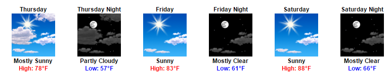
A gradual uptick in temperatures and humidity will most notably be evident on Sunday of all days this weekend. For a majority of the festival, afternoon highs will be in the 80s, except for an official high of 90ºF 0n Sunday.
Coolest Today, Warmest On Sunday
Celebrating Music, Hockey, and Great Weather

[av_textblock av_uid=’av-wd3lni’]
[cjtoolbox name=’Testing HTML 1′]
[/av_textblock]
Big Day For Nashville, Very Comfortable Conditions
Being probably the “pick day of the week”, today is and already has provided gorgeous weather conditions. A north wind continues to filter in cooler air for one more day, keeping our high temperatures down in the mid 70s!
Plenty of Sunshine, Cooler Temps Tomorrow, Temps Rebound into the Weekend
CMA Fest, Preds Hockey, Nice Weekend Ahead!
Sunny skies and mild temps will be the main story line for tomorrow. In addition, highs will be below average, staying in the 70s with dew point temps in the low to mid 50s. It will feel very nice AND comfortable outside.
Lots of Sunshine! Temps Creep Up Over the Weekend
For those planning to head out on the first day of things, it will be a lot cooler than it typically is. The high on Thursday will be in the mid-70s with dew point temps in a very comfortable mid-50s.
As we head into Friday and the weekend, things will begin to warm back up. Highs will reach into the low 80s on Friday, mid 80s Saturday, and upper 80s Sunday. Things may also begin to feel a fit stickier with dew point temps gliding back into the upper 50s to low 60s.
Sunny Days Are On The Way!
Weekend Starts Early With CMA Fest — Weather Looks Awesome
![]()
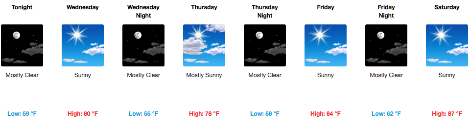
The string of the next 5 days looks spectacular. Temperatures and dew points stay low and bearable, especially Wednesday and Thursday. Temps will creep up as we get into Saturday and Sunday, approaching 90ºF for afternoon highs. As long as you’ve got sunscreen, maybe some cool sunglasses/hat, and some water to keep hydrated, CMA Fest weather will treat you very nicely this year.
bonnaroo looking great weather-wise!
We’re looking to be in really good shape for Thursday-Sunday. Temperatures will start Thursday-Friday in the low to mid 80s, creeping up towards 90ºF by Saturday and Sunday. Humidity will also increase a bit by the weekend.
Bonnaroo Updates – Check back soon!
As we move closer to Thursday, the weather still appears to be pretty fantastic. Sunny skies with highs in the 80s can be expected at this point. Dew point temps will start creeping up into the weekend, but other than that things should be in great shape!
Rain, Rain, Rain Today, Sunshine Returning Tomorrow
More Showers Tonight
Off and on showers will continue throughout the remainder of the day. Luckily, we are not expecting a washout with any showers we see.
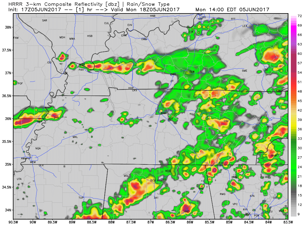
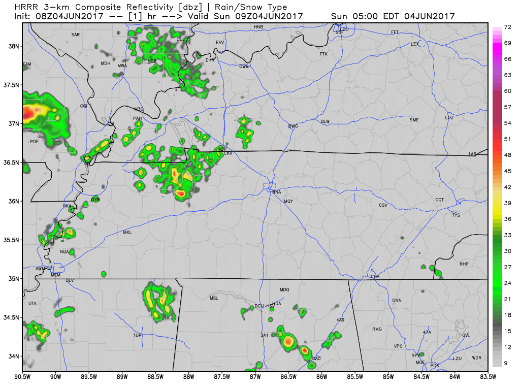
HRRR Loop Now Through 6 AM
The semi-bad news for this evening is that it appears the rain could very well stick around into the evening hours. If you have plans to be outside tonight (a.k.a. going downtown to watch the Preds game), bring the rain gear if you do not want to get wet.
Rain Tonight & Tomorrow; CMA Fest Looks Kinda Great
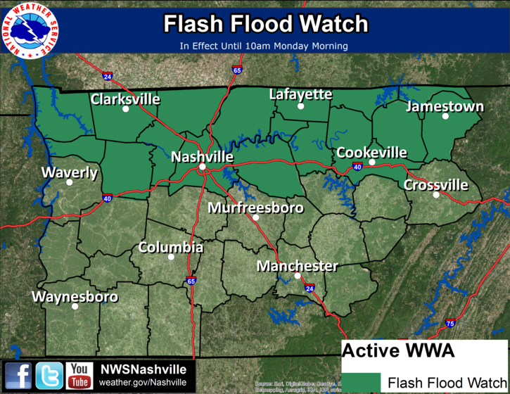
Flash Flood Watch for Davidson County until 10:00 am Monday.
Our NWS has their eye on the possibility of training thunderstorms overnight. So, they’ve issued this watch. We’ll keep an eye on it as well.
Thru 3:30 PM, radar estimates 1″ of rain has fallen (in yellow, below), mostly in Williamson County:
“Deep Moisture Regime” aka It’s Gonna Rain
This morning, NWS-Nashville wrote “Today through late Monday…the mid-state expected to remain in deep moisture regime…with a series of upper impulses passing …and with a few weak low-level boundaries in the immediate vicinity.”
You must be logged in to post a comment.