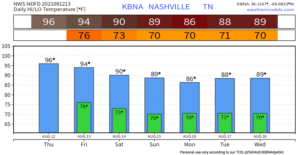
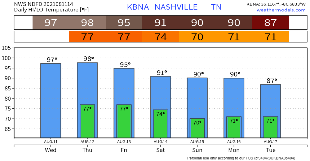
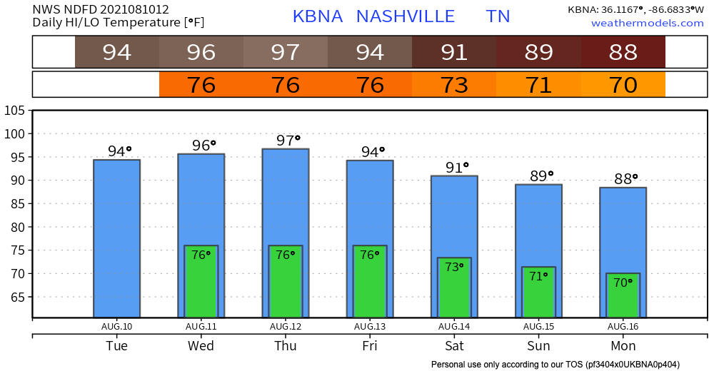
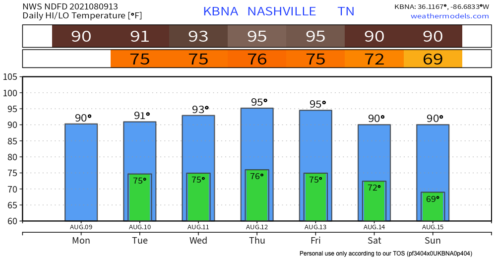
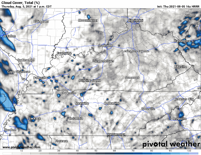
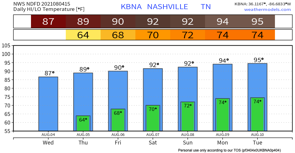
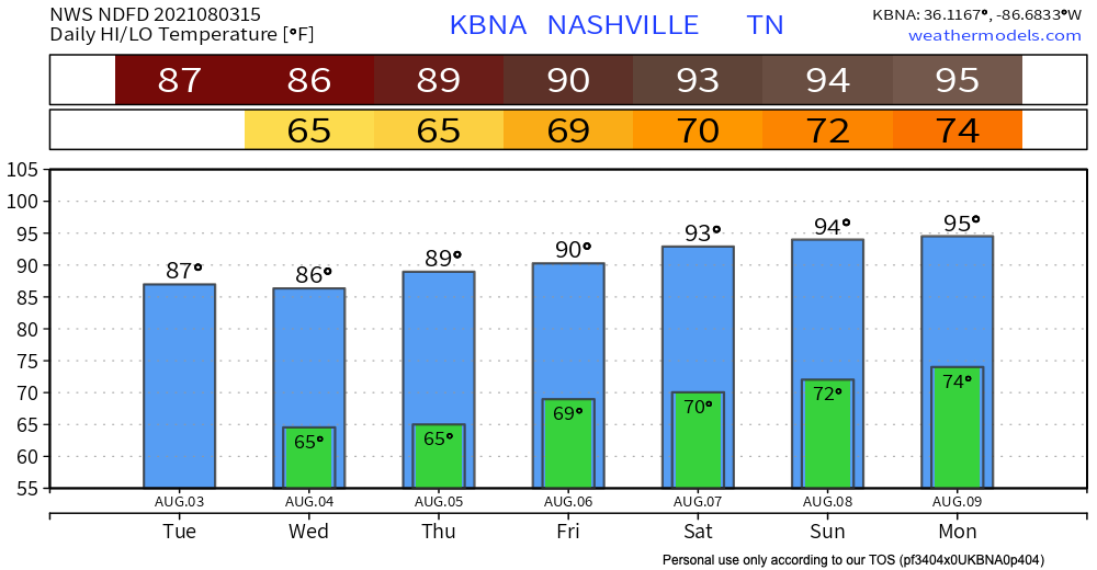
About Last Night
The line between rain and snow isn’t always east or west like it was last night.
It’s also a matter of elevation.
Snow in Boston, TN (SW Will Co) hit 3.5″ last night. Legit snowmen were rolled up in Leiper’s Fork:
The real story here is that rain will begin pretty soon. JK the real story is that there is a non-zero chance of snow tonight and tomorrow morning. Let’s dive in…
After the afternoon rain event today (mainly after 5pm), temperatures will drop below freezing and that rain will transition into a rain/snow mix.
Nashville, although, is only expected to see less than half an inch. If anything, we will just get a dusting.
In general, impacts remain low. Temps should hover just a little bit above freezing at the surface in Nashville, but in the hollers, if it’s colder, bridges and overpasses could be impacted. Regardless, if you plan on traveling anywhere tonight or tomorrow morning, be cautious!
Let’s take a look at forecast models.
The Euro model (above) shows the snow Friday staying to the east. Other models show lingering moisture and weak lift which should be enough for some areas to see flurries.
Here’s what the NWS says…
IT STILL LOOKS LIKE THERE MAY BE A BRIEF PERIOD OF MIXED PRECIP THIS MORNING ON THE LEADING EDGE OF THE PRECIP WEST OF I-65 AND LOOKS TO BE ALL RAIN THROUGH THE DAY THEREAFTER. AFTER SUNSET, TEMPS WILL DROP TO THE MID 30S BEFORE 9 PM, AND PRECIP WILL CHANGE FROM RAIN TO A RAIN/SNOW MIX, FOLLOWED BY ALL SNOW JUST AFTER MIDNIGHT. HIGHER ELEVATIONS INCLUDING THE PLATEAU MAY COOL OFF A FEW DEGREES SOONER, AND SEE ALL SNOW BEFORE MIDNIGHT. SHOULD TEMPS COOL OFF A BIT SOONER AREA WIDE, WE MAY SEE MORE SNOW, AND IN THE OTHER DIRECTION, SHOULD TEMPS STAY WARMER, SNOW WILL BE DELAYED AND AMOUNTS WOULD DECREASE.
Today will be the warmest day in the next seven days ahead. We’re pushing a bit above average. That’ll change starting Tuesday.
Nothing but sunshine these next few days!
Both the Euro and GFS have rain beginning around noon Thursday moving out of Middle Tennessee by midnight.
Out with the old and in with the new. We wish you a happy and healthy new year!
Maybe you woke up to some moderate pattering on your window this morning, maybe you didn’t.
The last of the showers and thunderstorms from this system is pushing off to the east and leaving us with a really nice day outside.
I know most of us are pretty excited to watch 2020 go and move into the New Year of 2021!
The weather, unfortunately, remains gross – rain, rain, and more rain.
HRRR model indicates some light rain/drizzle on and off until early afternoon hours. We’ll see a break in the rain from mid-afternoon until early this evening.