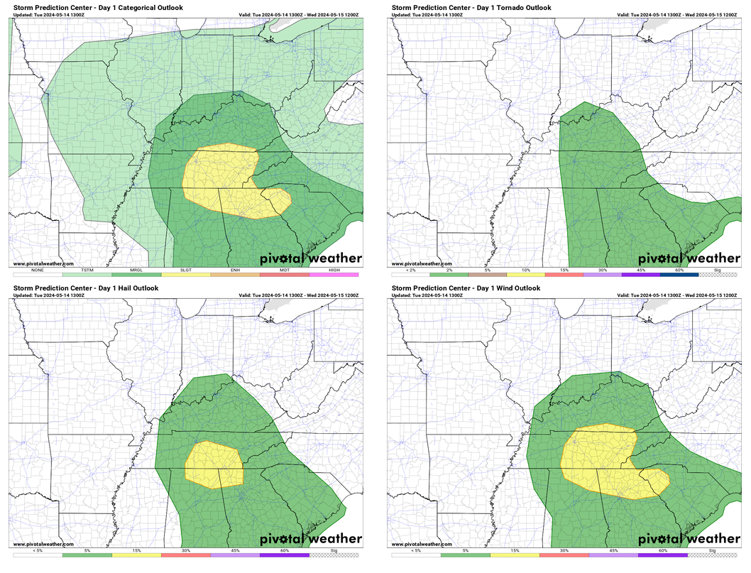
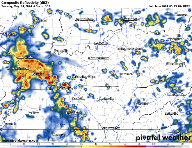
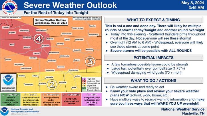
Storms expected this evening and tonight. Low tornado thread added.
Within 25 miles of you tonight, there is a 2% chance of a tornado occurring, a 15% chance of damaging wind occurring and a 5% chance of large hail.
Storms expected this evening and tonight. Low tornado thread added.
Within 25 miles of you tonight, there is a 2% chance of a tornado occurring, a 15% chance of damaging wind occurring and a 5% chance of large hail.
Another very warm day is in store Thursday, high temperature expected to end up around 86°. Record high at BNA is 88°, could get close to at least tying.
Thursday evening into the overnight hours, a line of storms with heavy rain, lightning and gusty winds are expected drop down I-24, therefore nicknamed an “I-24 Special”, although it is debatable if they are actually special.
Storms likely Thursday night — Models think no storms today. The atmosphere would support severe weather today if storms could get going, but the last several runs show nothing happening.
But tomorrow/Thursday night a storm complex should drop down I-24 from Kentucky, aka an “I-24 Special.” These are usually dog stressors and noisemakers, with a lightning lottery.
Another very warm day to add onto to our string of other very warm days.
Wednesday and Thursday will follow suit with highs in the low to mid 80s. Friday will begin a weekend of some cooler temps, with highs in the 60s for the most part.
Storms incoming predawn/sunrise tomorrow (Weds) morning. Lightning and briefly heavy rain. Severe weather not expected. Storms lacking key ingredient: CAPE, which is near zero.

Weds afternoon/evening remains questionable. Previous models showed storms in place, with plenty of storm-making ingredients. While the tornado threat appears to be well north of us, the atmosphere could support heavy downpours, lightning, and low probability of damaging winds and hail. However, the last several model runs do not show any storm formation after the storms that will come through early in the morning.
Very warm today and tomorrow. Record high temps for BNA are 87° and 88° for today and tomorrow, respectively. Not quite sure we’ll make it to either of those, but it’ll be close.
We could see some light showers early Tuesday morning, but these will be light and NBD.
Rain arrives early Tuesday evening if you want to believe the HRRR model. Never believe one run of one model. Remain curious for future runs. Understand rainouts/interruptions will be possible Tuesday night.
Monday looks like a great, dry spring-like day. High temperatures getting all the way into the mid 80s.
Tuesday still looks warm, but a few showers may swing around during the morning and evening hours.
There could be a few storms Tuesday night as a weakening line of storm approaches the area, but no severe concerns for our area.

That line of showers/storms should be moving out by rush hour Wednesday AM, but we could be dealing with more storm chances later in the day.

The Storm Prediction Center has included the far northern portion of Davidson Co. in a 15% chance of severe storms within 25 miles for Wednesday. This is still several days out, so a lot will change between now and then.
"Uncertainty continues on how strong or
widespread this activity may get as the upper level low weakens
while moving even further northward away from us, taking the main
upper forcing with it. Nevertheless, forecast soundings continue
to show quite favorable parameters for some strong to severe
thunderstorms ahead of the front, especially across our northwest
half, so we will have to keep a close eye on this potential." - NWS Nashville
Big warm up starts today as highs will get up into the upper 70s, then low 80s for the first half of the new week.

We should be able to get away with a dry weekend, only hiccup may be an isolated shower Sunday afternoon, but majority of models keep us dry.
Winds will die down tonight, leaving us with crisp temps in the mid to upper 40s. Big warm-up starts Saturday, with a high of 76° and mid-80s by early next week.

Since it’s Spring and all…we live among the battle of the air masses. So, our next storm system moves across the central US just as we start warming up. The system should arrive here around Wednesday and could hang around until the weekend. While we are not currently outlooked for severe weather, it will bear watching. We can’t turn our backs to the western sky this time of year.
You must be logged in to post a comment.