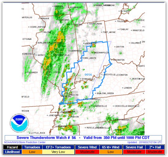
Decent Weekend. Snow/Flurries Monday, But Not A Big Deal

Current Radar 

The Weekend – Not Bad!

Just below freezing in the morning, then warming into the mid-50°s while clouds arrive Sunday after dark, announcing our next system.

Things Get Interesting Sunday Night – Monday Morning – Monday Night

A big trough of arctic air will begin its approach. By midnight Sunday evening, it will have already started its push into Middle Tennessee. read more

Clearing & Cooler!

Current Radar 

Thursday – Sunny – Waking Up: 31° High: 43°

Seasonable temperatures overnight Wednesday into Thursday morning. Low temperatures will be just below the freezing mark under a clear sky.

High pressure will build in from the southwest while winds filter in the cold air from the north during the day on Thursday. read more

Severe Storms En Route

Current Radar 

TODAY – Wind Advisory All Day. Severe Weather Tonight. – High: 74°

Overview: We’ve got several things happening today. This morning, we’ve dealt with fog. It’s going to be incredibly windy today – windy enough to have put us under a Wind Advisory. Finally, severe storms remain the forecast for tonight, all thanks to the system below:

Plenty of fog around this morning…enough to warrant a Dense Fog Advisory, but it expired around 8 AM and should be clearing or already have cleared.

At 9 AM, a Wind Advisory went into effect. It’ll last until midnight. read more

Rain Slowly Departing Today, Severe Weather Arriving Tuesday

Current Radar 

Today – Overcast and Rainy High: 60°

Current radar shows showers with some thunderstorms around our area this morning. The heaviest batch of rain is to our east at the moment. The Storm Prediction Center put a pocket of General Thunderstorms in Middle Tennessee for today. Showers should taper off to the east after lunchtime today. No severe weather today. read more