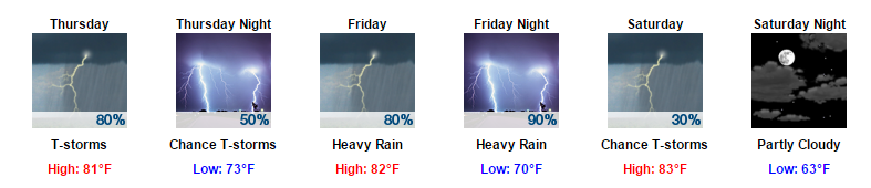
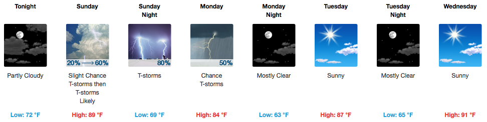
Flash Flood Watch in Effect; Turn Around, Don’t Drown

More rain, with maybe a little lightning, is on the way tonight.

Flash flooding (a flood that happens almost suddenly, due to heavy rain and run off) is tonight’s primary weather concern.

A lot of rain has fallen. The below map is a radar estimate as of 6 PM. The purple indicates radar estimates of 1.5″ to 2″ or more, and are especially vulnerable to flash flooding tonight/overnight. read more

Father’s Day Storms

Today’s Father’s Day forecast is kinda like this.

Expect thunderstorms.

At 8:45 AM, weak storms near Paducah, KY, are moving slowly our way down I-24. Those storms should strengthen as they approach and encounter a hotter, more destabilized airmass here in Davidson & Williamson Counties. read more

Dry Tonight, Heat and Humidity Through Weekend

Rain Done For This Evening

Heading out the Sounds game tonight? Other than wiping off your seat, we will remain dry!

Unsettled Pattern Continues + Heat and Humidity

GFS Model Through Tuesday AM

A continued string of hot and humid days is expected into the weekend, so don’t forget to throw in those pesky afternoon storm chances each day! Sunday looks to be oppressive humidity/heat-wise, and is also when our much greater chance for more widespread rain and thunderstorms will return. A cold front will clear through the area on Monday bringing drier and a *little* cooler air (89ºF for next Tuesday afternoon instead of the recent low to mid 90s). read more

Slight Risk of Severe Weather for Tomorrow


Showers and a Slight Risk of Severe Weather for Thursday

Another batch of early morning sunshine is expected tomorrow with highs reaching into the 90s. By the afternoon, showers and thunderstorms could develop with some becoming severe.

When: Afternoon to Evening Hours

Once we reach the afternoon hours, it will become fair game for showers and thunderstorms to develop. Models are a bit inconsistent when it comes to timing for tomorrow, hence the large time frame. read more