Current Weather and Rest of Today
If you were woken up by some rumbles of thunder earlier this morning, you weren’t alone. Our greatest chance of rain has already moved through the area as we were all getting up for the start to our day.

If you were woken up by some rumbles of thunder earlier this morning, you weren’t alone. Our greatest chance of rain has already moved through the area as we were all getting up for the start to our day.
The High Resolution Rapid Refresh model below gives us some art. You can see that it’s pretty hot, and most runs are just like this.
Rounds of non-severe showers and possibly storms continue most of the day. A couple HRRR runs throw some stronger storms into both counties around 4pm. Not totally sold on that right now.
Editor’s Note: welcome Sheyenne, Intern 6.0. She is one of four of the new group of interns. She drew a tough assignment today. Handled it great!
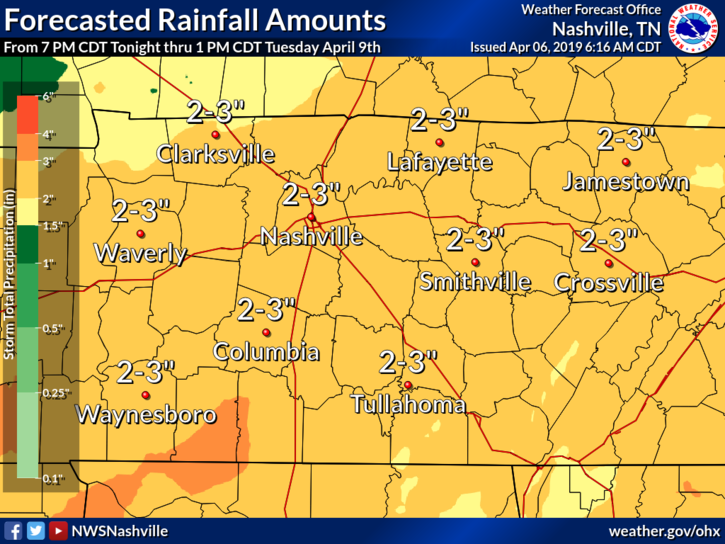
Currently, a low pressure system is beginning to work its way through Texas. This will enter our region, bringing rain and thunderstorms Monday.
Editor’s Note: NWS published this in their 6pm AFT Sunday Evening…
HIGHEST RAIN CHANCES TONIGHT WILL BE AFTER MIDNIGHT WHEN REMNANTS OF THE TX/LA MCS MAY SPREAD NORTHEASTWARD. RAIN CHANCES WILL REMAIN HIGH MUCH OF MONDAY AND MONDAY NIGHT AS THE UPPER LEVEL LOW OVER TX MOVES EASTWARD ACROSS THE GULF COAST STATES. SOME THUNDERSTORMS ARE POSSIBLE MONDAY ESPECIALLY OVER SOUTHERN COUNTIES BUT SEVERE STORMS ARE NOT EXPECTED AS INSTABILITIES SHOULD BE LOWER.
Weather models are lighting up with storms overnight tonight through Sunday. Timing, and how bad they may be, ↓↓↓↓.
Timing and model runs vary. No real ETAs or time-specific details available. Rain and storms will come in irregular waves.
EDITORS NOTE: This is Marti’s last blog for us as an intern. She has really grown as a writer and we are very proud of her work. Best of luck, Marti!
If you enjoy warm and sunny, then soak up the sunshine while we’ve got it! Starting tonight we’ll be rain-soaked until Tuesday.
The rain is outta here! Weak high pressure has taken the reigns of our weather and will keep us dry for the remainder of the day as temperatures soar into the middle 70ºs and dew points stay in the 50º. The only issue outside is the pesky yellow stuff that people like to store on their cars!
Our dry, sunny skies have moved on to the east, pushed out by clouds and rain. The NAM 3km below shows the widespread rain that’s taken over the southeast.
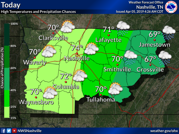
Even with rain and clouds, our high temp will warm into the low 70°s by the afternoon.

Enjoy today’s sun! After today, a wet pattern will move in. Expect a high of 73º this afternoon.
Clouds will begin to build in overnight with temperatures not falling as much as they have been the past few nights. Our overnight low is expected to sit just below the 50º mark at 49º. Certainly a far cry from the near freezing temperatures we had at the beginning of the week.
Warming trend continues today with clear, sunny skies. High temp in the mid 60°s. Weak high pressure is building in, cutting off any chance of rain this afternoon/evening.
High pressure will be in control most of Wednesday. No rain expected; sunny in the morning, clouds taking over in the evening.
Dry first half of the week. Warmer each day.
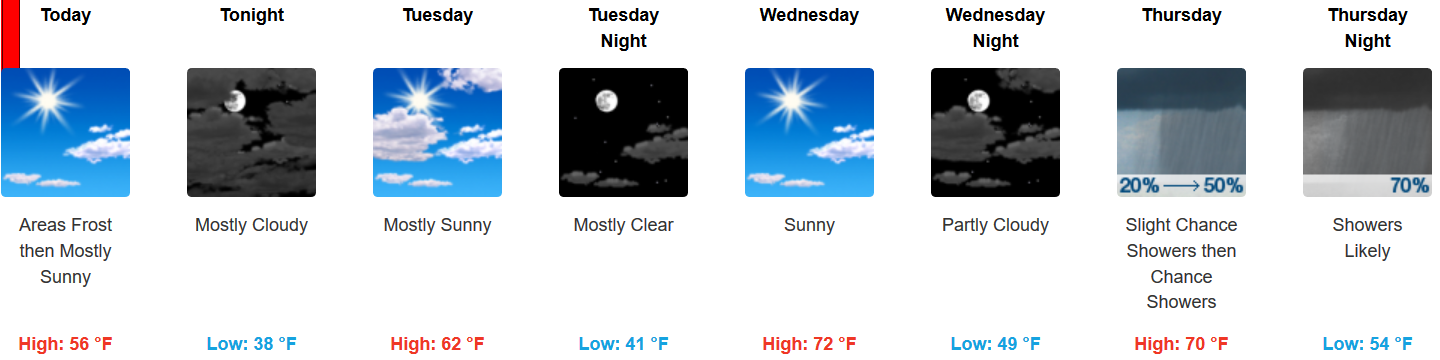
May see frosty-freezy temps early Tuesday morning in low-lying spots.
No rain until late Thursday night.
Rain expected as early as late Thursday night but is most likely during the pre-dawn hours Friday morning. Expect about a half-inch of rain. Should depart before lunch, if not sooner.
You must be logged in to post a comment.