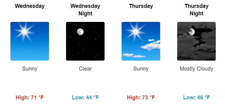
Another warm and pleasant afternoon today! The last one this week, sorry to say.
Rain Friday through Saturday

Light rain will begin sometime around/after lunch Friday then continue throughout the day, becoming heavy at times through Friday night.

Another warm and pleasant afternoon today! The last one this week, sorry to say.
Light rain will begin sometime around/after lunch Friday then continue throughout the day, becoming heavy at times through Friday night.
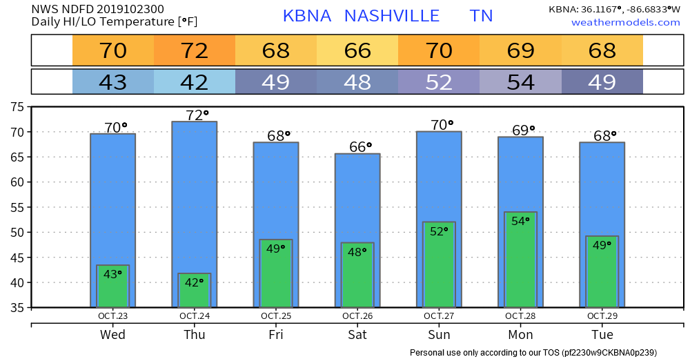
Pleasant today and Thursday with normal-for-October temps for the next 7 days. Then imagine a kinda chilly soaking rain event starting Friday (night?) and lasting into Saturday and maybe even into Sunday, gross.

Rain: passed.
Skies: mostly sunny.
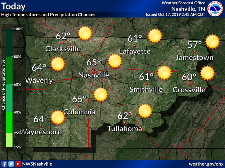
Overall, beautiful weather today with a high temperature of 67°.
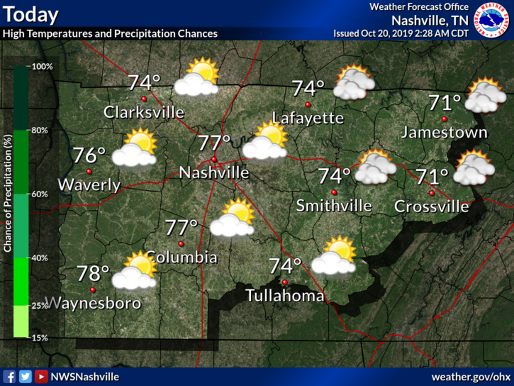
High temperatures gradually warm back up to slightly above-average.
Low temperatures will be a little chilly, so be sure to pack a jacket if you leave for work early in the morning.
The storms that formed west of us have fizzled almost completely. This was expected to occur. However, the main front is still back to the west and could set off additional showers and thunderstorms as the day goes on. Instability (storm food) will be weak, so we’re not too worried about severe weather.
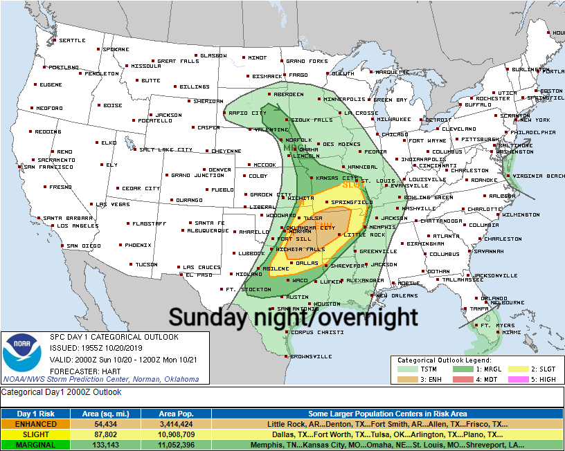
Overnight tonight into Monday morning, heavy rain, carrying potent tornado, hail, and damaging wind risks, will spread east from eastern Oklahoma into NW Arkansas.
This system is moving our way but will weaken substantially by the time it arrives Monday.
Today will be comfortable and beautiful:
Clouds this morning should clear throughout the day, giving us partly sunny skies.
As a cold front moves through tomorrow, we can expect a bit of rain. Thunderstorms can’t be ruled out, including severe (though this threat is low).
We start off the morning a bit chilly, about 45°F at the time of writing this (7:50 AM.)
But it’ll warm up quite well into the afternoon, with our high approaching the low 70°s.
Tropical Storm Nestor will be working its way inland today, which is the reason for the slight chance of rain today.
A high pressure is going to keep us dry throughout the day today. Temperatures climb from that cool brisk air we felt this morning to around 70 ° for the high.
Mostly sunny for this afternoon and perfect weather for some Friday afternoon/evening plans! Be sure to get out and enjoy the sunshine before tomorrow’s increased cloud and rain chances!
Other than waking up to some very chilly weather, I have no complaints about today:
If you’re out tonight or early Friday morning, be sure to bundle up:
Expect a repeat performance today and tonight with clear skies across the region and temperatures running about 5 to 10 degrees below normal which may again result in patchy frost tonight, particularly across the Plateau.
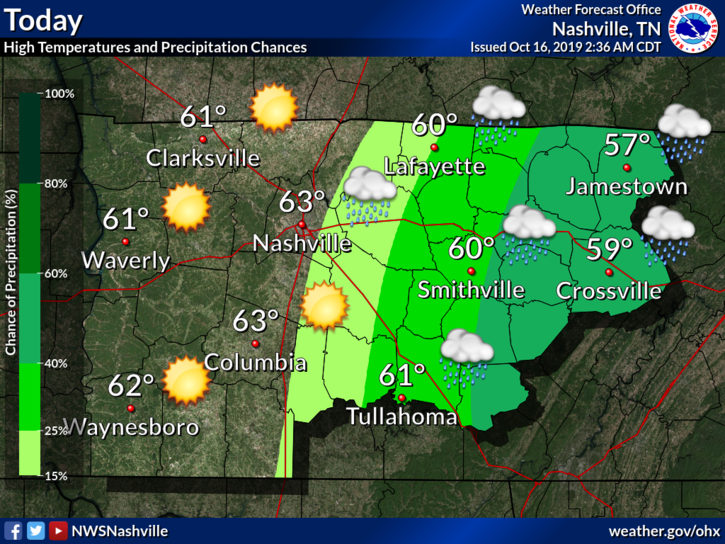
Today we should reach into the low 60°s with clearing skies as last night’s rain moves out of the area.
This is thanks to a cold front. The wind is pretty cold, though.
Our low overnight into Thursday morning is brisk:
You must be logged in to post a comment.