The rain has ended, the clouds are gone and the sun has returned for the weekend!
We’ll see an afternoon high around 58°, unseasonably warm for early January (47° is normal). Once the sun goes down, though, temps will drop into the mid 30°s.

The rain has ended, the clouds are gone and the sun has returned for the weekend!
We’ll see an afternoon high around 58°, unseasonably warm for early January (47° is normal). Once the sun goes down, though, temps will drop into the mid 30°s.
Rain is the story of the day across middle Tennessee as the low-pressure system we have been talking about for the past couple of days makes it’s way through. The center of the low will track right over southern Tennessee today, though rain chances will become limited due to a more northerly track than what was expected.
This morning’s rain has come to and end. For the bulk of today, we’ll stay dry with thick clouds remaining overhead. These clouds will help to keep us cool with a high around 47°.
More rain will arrive this evening as a low pressure center slides eastward from the Great Plains. The HRRR and NAM both think the rain should arrive around 9 PM. Our forecast low is 39°.
The forecast high today is 47°.
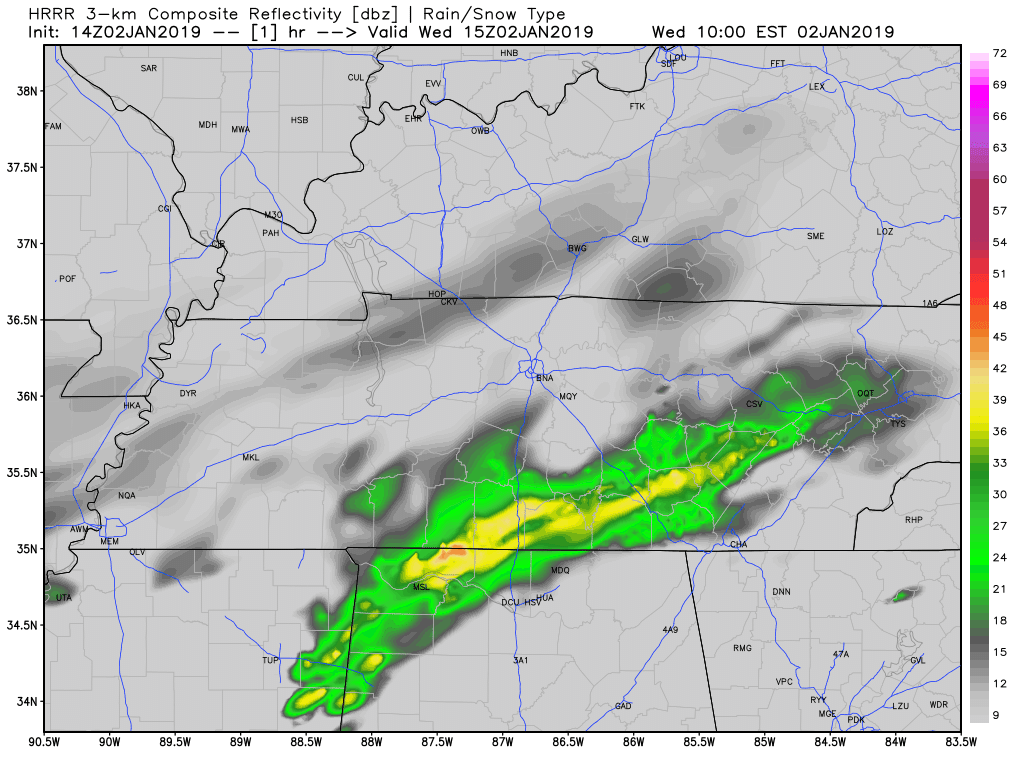
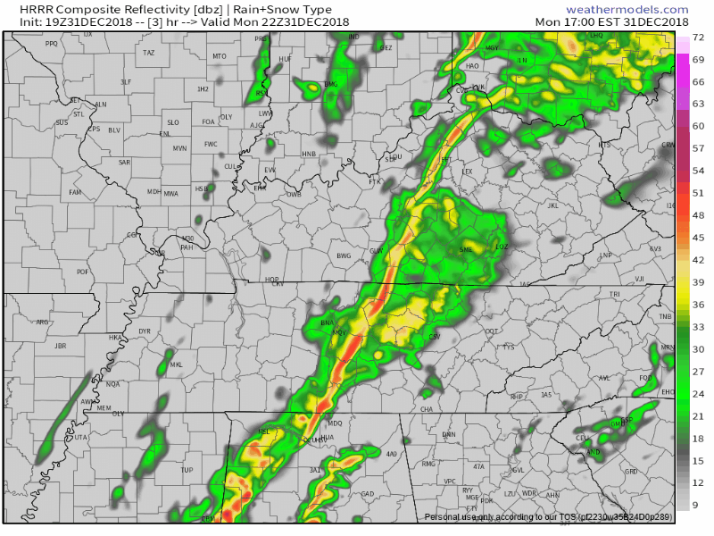
A few showers were spotted around Nashville this morning, a pre-cursor to what we are expecting this afternoon. Rain will gradually move into Williamson and Davidson Counties from the southwest, encompassing all of the area right around dinner time. Keep an umbrella handy in the meantime. Isolated showers will continue in advance of the main event. HRRR Model illustrates how it may pan out.

Most people’s New Year’s Day is ruined by New Year’s Eve alcohol. Mine was ruined by two of these.
Had one at 3 PM, second one at 9 PM. I could not go to sleep until 2:30 AM. This morning I experienced a sleep-induced nerd hangover.
Today is a great day to do nothing. There’s plenty of college football on and no real reason to start any of those resolutions. Reality begins for most of us tomorrow.
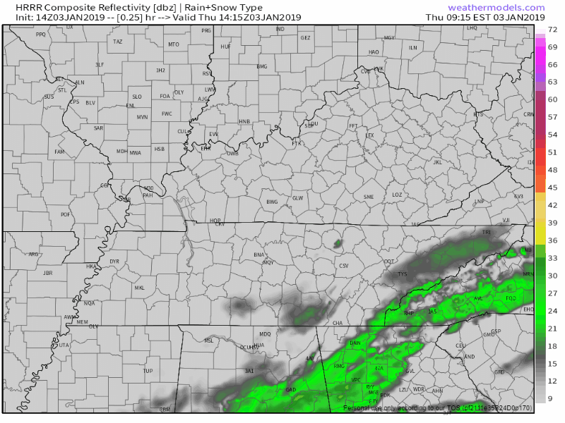
Wednesday will see our temps dip back to a more seasonally appropriate temp and we’ll see some rain sweet through after 7. It shouldn’t mess with rush hour and will be gone lone before Morning. Here’s a view of what the NAM thinks, and most other models agree. No shenanigans are expected.
The Tornado Watch and storm threat is over.
Localized flooding with a rise in area creeks, streams, and rivers has been the legacy of the departed storm line. There were also a few wind-related damage reports. Check out a sampling of reports on #tSpotter. Or just this one:
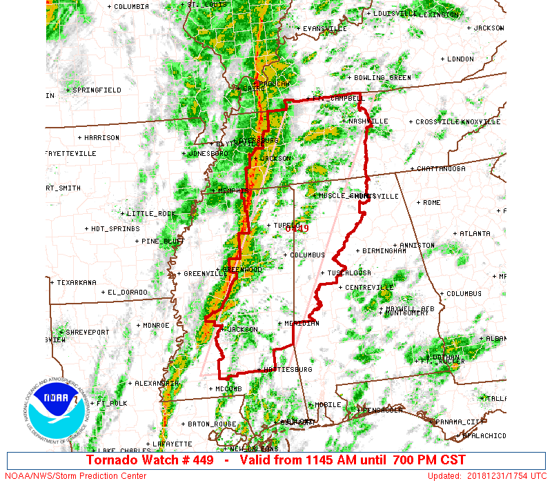
From the Storm Prediction Center:
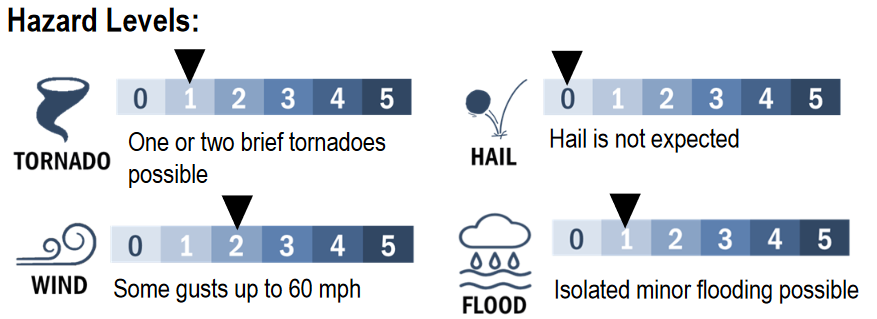
Primary threats include…
- A couple tornadoes possible
- Isolated damaging wind gusts to 70 mph possible
A Watch covers a large area and means Be Ready, conditions are favorable for a tornado.
A Warning covers a smaller area and means Immediately Take Action/Shelter, a tornado is occurring or imminent inside the warned area.
A Wind Advisory starts at 9 AM and ends at 6 PM. Winds will gust into the 30 MPH range, with scattered occasional gusts up to 45 MPH. With heavy rain last night, sick or shallow-rooted trees may come down should one of those 45 MPH gusts find them. These are winds independent of storms coming later today.
Light rain is arriving now. On Twitter I’ll be covering the impact, if any, this rain has on the Titans game, so let’s just move on to New Year’s Eve, because there’s a lot to say about it.
You must be logged in to post a comment.