
Rain ended – OK maybe a few more light rainers or drizzlers tonight – but flooding threats remain as water continues to runoff into rising creeks and streams. Be especially careful at night when darkness hides flood dangers.

Rain ended – OK maybe a few more light rainers or drizzlers tonight – but flooding threats remain as water continues to runoff into rising creeks and streams. Be especially careful at night when darkness hides flood dangers.
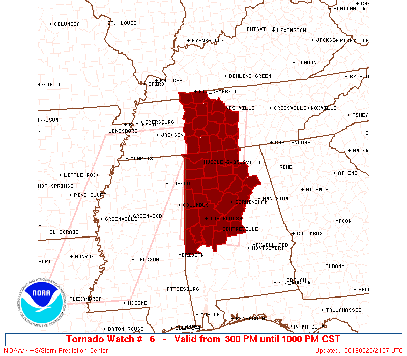
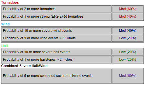
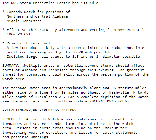
A Tornado Watch has been issued for Davidson and Williamson Counties from 3 PM until 10 PM.
As storms approach from west to east, our winds will pick up. Wind gusts upwards of 35 to 55 mph (higher within storms) can easily cause a tree to fall due to the saturated/weak roots. Again, don’t park beneath a tree that could fall.
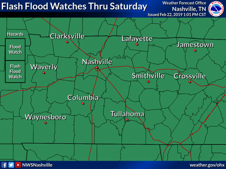
A Flash Flood Watch continues until midnight tonight. We’re expecting another few inches of rain here in Nashville, so flash flooding is still a concern.
The axis of heaviest rainfall is expected to set up just to our southeast, but we could see another 2″ to 3″ here in Nashville. Rivers and streams already full of water could rise more if this pans out.

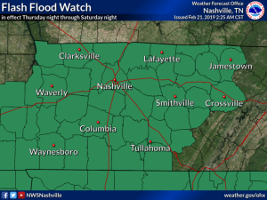
Our Flash Flood Watch continues through Saturday. We are expecting another couple of inches of rain overnight. More details below.
Overnight Flash Flooding Possible
Don’t let your guard down just because we’ve got light rain on the way to bed. We’re expecting at least another inch, perhaps 2″- 3″ of rain here in Middle Tennessee overnight.
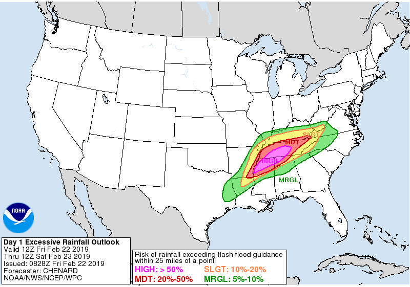
“A major flood threat will focus over areas south of I-40 this morning through Friday” [then will] “continue for areas south of I-40 and spread northward covering all of Middle Tennessee [including Nashville] Friday night through Saturday.” –NWS-Nashville
Summary
After a brief drying period, rain has arrived and will continue through Saturday night. A flash flood watch is in effect for the entire Middle Tennessee region including Davidson and Williamson counties from tonight until Saturday evening as the potential exists for an additional 2- 4 inches of rain, with locally higher amounts where storms tend to “train” or sit over an area dumping rain. The concern for flooding is big. Another issue that we may have to deal with is a potential severe storms Saturday afternoon. More on this later. A cold front sweeping through Sunday will bring a much needed end to the rain with temperatures remaining right around normal or just a couple degrees above.
We’ve had Flash Flooding this morning. More rain, a bit lighter than what we saw this morning, is on the way this afternoon. It should end tonight. Thursday we will have have a short break from rain, with more rain approaching Thursday night and arriving Friday. Additional flooding possible Friday. Saturday will also be rainy, with potential for additional flooding and severe thunderstorms.
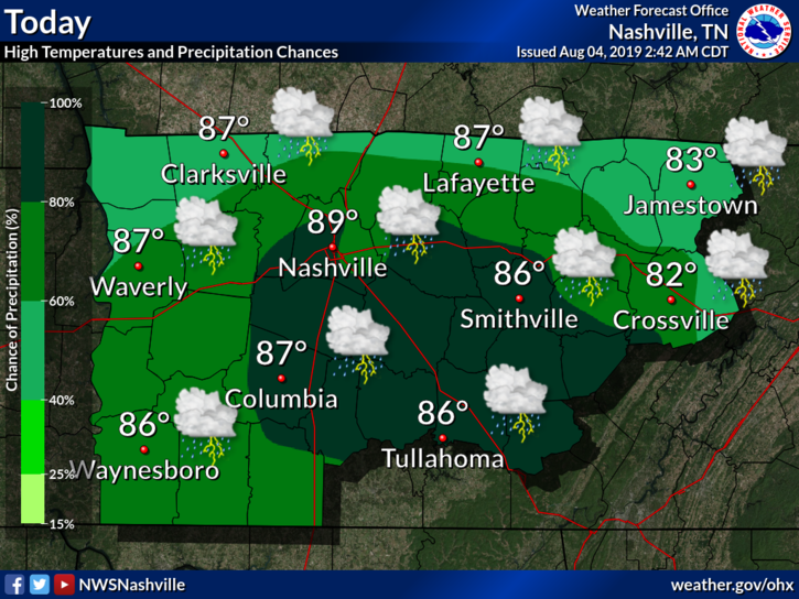
Forecast totals from NWS-Nashville:
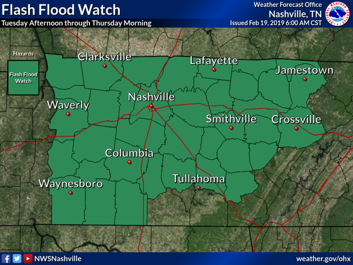
A Flash Flood Watch goes into effect this afternoon and lasts until Thursday morning for Nashville, Williamson County, and most of Middle Tennessee.
Rain will start this afternoon, so be sure to have that umbrella handy. Rain will intensify during the evening commute, becoming more widespread by 4:00 PM – 5:00 PM, and continuing into the evening.
Well, if you’re sick and tired of the rain, I have some bad news for you…it isn’t over just yet. Middle Tennessee is going to see numerous waves of heavy rainfall and flooding Tuesday through Sunday.
When will the rain end?
Hang in there, HRRR and NAM think the rain should come to an end about midnight. Temps will drop overnight, falling to the upper 30°s by Monday morning’s commute.
The band of rain has slowed down, allowing more rain to fall over Nashville than previously thought, we could expect 0.5″ to 0.8″ through the night. NWS Nashville does not expect flooding concerns today.
You must be logged in to post a comment.