
The heavy rain is finally over for us and our western neighbors.
Today the HRRR shows some showers to our south in the late morning. If anything does pop up in your neighborhood, it will be brief and of little consequence.

The heavy rain is finally over for us and our western neighbors.
Today the HRRR shows some showers to our south in the late morning. If anything does pop up in your neighborhood, it will be brief and of little consequence.
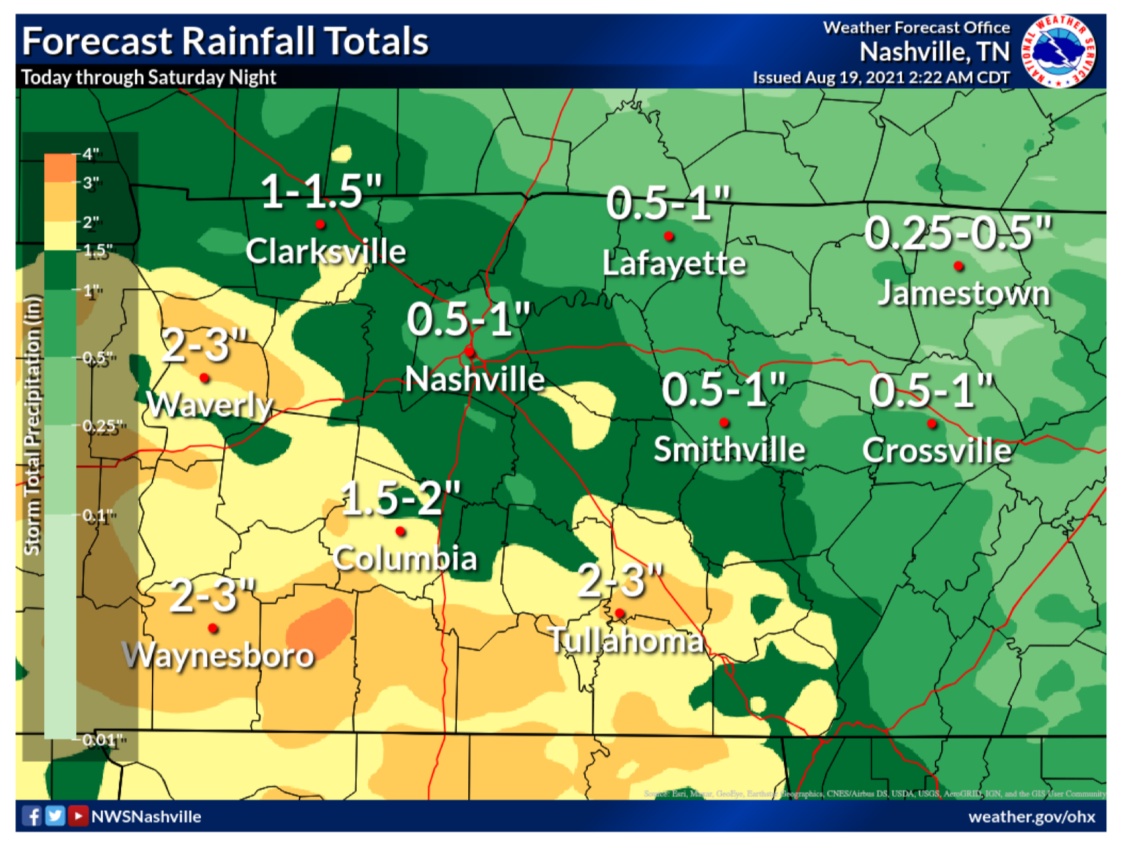
Editor’s Note: Flash Floods. We’ve been through them. They’re a painful reminder of how quickly weather can take away what has taken years to make…homes, businesses and beautiful landscapes. Today, our friends just to our west are dealing with catastrophic flooding with well over 11 inches of rain, maybe much more, falling just this morning. The beautiful Piney River is roaring at 31.8 ft at the time of this writing, a staggering 7.8 ft above MAJOR flood stage. If you have friends in Humphreys, Hickman, Dickson or Houston Counties, please check on them by phone/text if you’re able. They’re going to need much to rebuild what water has taken away today.
Scattered storms from last night have lingered around and are still in our area this morning. HRRR has these storms hanging around most of the day. No severe weather is expected with these. Main concern is lightning and gusty winds.
Storms don’t reach our area again until 1-2pm. These won’t be as widespread as yesterday. Only threats with this batch is lightning and wind gusts. No severe weather is expected. Scattered storms continue into early Friday morning, see HRRR below.
The Storm Prediction Center believes there’s a 5% chance you will see damaging straight-line wind within 25 miles of you today and tonight. While the threat is low, it is not zero. Two of our communities have seen the affects of microbursts recently, Oak Hill and Nolensville. Will we see another one today? We don’t know. But, the chance is there and worth noting, especially if your plans include being outdoors.
Scattered rain activity and overcast skies in store for our counties. Chances are best this afternoon, but most won’t see anything. Those that do get storms likely won’t see anything severe with these, just brief downpours and the occasional rumble of thunder. See the HRRR below.
Like yesterday, this morning is very foggy, and tomorrow morning could be as well. Remember to drive carefully if you encounter any dense fog.
It’ll be another hot and humid day, with dewpoints in the 60s and 70s.
There was fog this morning and there will probably be fog tomorrow morning. Consider printing this graphic and sending it to other drivers. We know you, loyal reader, drive perfect. The problem is other drivers.
Fog this morning mixed out fairly quick. Here comes another day of hit or miss showers/storms and a little less heat than the past few days.
Similar to yesterday, storms should start popping up sometime in afternoon, then slowly start to dissipate by sunset. It is entirely possible you don’t get any rain today, but if you do, a storm could contain some heavy rain, gusty winds, and lightning. A storm or two could contain microburst winds, similar to what parts of Nolensville saw yesterday. Microburst winds cause damage to low-end tornadoes. They are can be difficult to warn on because they occur between radar scans. No organized severe weather or tornadoes are expected today, or the next few days.

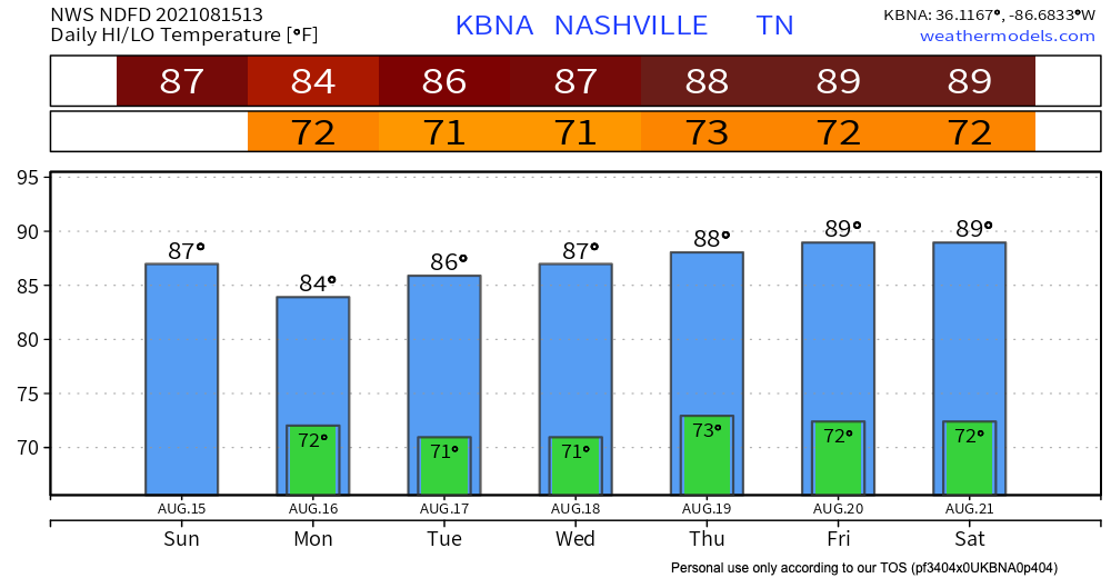
Happy Friday the 13th! Today is like the disgruntled middle child caught between yesterday and tomorrow. Highs are on a downward trend to the low 90s. Let’s not get too ahead of ourselves now… dewps in the low to mid 70s could still give us our most beloved 100+ heat index. No more heat advisory, so that’s good news. Practice heat safety anyway.
You must be logged in to post a comment.