Heat, Humidity, Rain Chances Return

Image result for friday gif

Here Comes the Heat

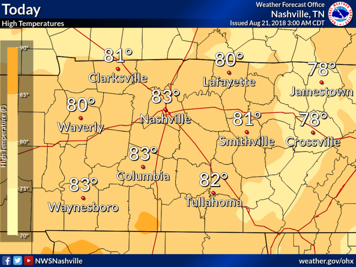
Did you get a chance to step outside this morning? It was hard to believe it was still summer! However, by this afternoon you’ll have no doubt it is still mid August. 

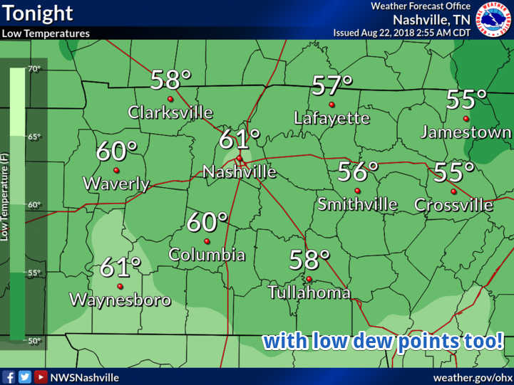
A High pressure system, the weather feature that was giving us this relatively cool and tranquil period, is beginning to shift to the east, making way for temperatures and dew points to rise. Humidity will remain comfortable for the time being as it will take a day or two for the dew points to rebound into the uncomfortable and oppressive range. read more

Beautiful Today; August Heat and Humidity Return For The Weekend

Pleasant temps for another day!

Mid 80s for the high temps today. Northwesterly winds continue to push dewpoints down into the low 50s. Long story short, it’ll be a beautiful day!

We’ve got clear skies overhead as a surface high is located just to our north. A few clouds from a disturbance out west could wander into Williamson and Davidson counties sometime today, but no rain. read more

Cooler, Drier Weather Ahead, But It’s Not Here To Stay

Brief Relief!

I think it is safe to say that yesterday was noisy, especially late last night when those NE-moving cells intensified over our heads.

A cool down begins today, happening slowly but surely.

High temperatures will be in the low to mid-80s today as the cold front we talked about yesterday approaches and finally passes by this evening. The average high is 88º for this time of year. read more

Storms Possible This Afternoon, More Likely Late Tonight; Humidity Relief Arrives Tomorrow, Lasts Through Friday

Severe storms should develop along the Mississippi River later today. The system will move our way and is expected to weaken on arrival.

Details

The Storm Prediction Center has us placed within its “Marginal risk” (1 out of 5) of severe weather today. UPDATE 8:00pm SPC has now upgraded parts of both counties to a “slight” (2 out of 5) risk of severe weather. read more

Monday Morning Rain/Storms, Evening Storms May Be Strong; Cool & Dry Wed-Fri

If I could summarize Wednesday to Sunday in one GIF, it’s this one:

But first, details on rain and storm potential Monday morning, Monday night, and early Tuesday morning.

Monday – Early Tuesday

Two waves of storms are expected tomorrow. The second wave — arriving Monday night — may pack a punch. Below ETAs will need adjustment as models run and the rain shows itself on radar. Use models for guidance, not Gospel. read more