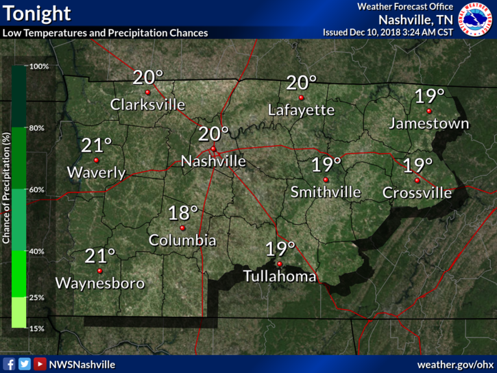
Rain is Here; More Rain (Storms?) Possible Tonight & Friday

We’re expecting a high of 84° today. You can thank the clouds and rain-cooled air for that. Dewpoints will remain in the upper 60s and low 70s from tropical moisture funneled into Middle Tennessee. Cooler temps, but uncomfortable humidity. read more

Rain on the Way

Here Comes the Rain

Who is ready for some rain?! It’s coming. Tropical moisture is arriving.

The HRRR model below shows off and on showers this afternoon, then a lot of light arriving arriving after midnight.

We are expecting the high temperature to be right around 90º today with dew point temperatures in the upper 60s (uncomfortable range). read more

Hot and Muggy; Afternoon Rain Chances; Rain and Storms Possible Thru the Weekend

We’ve got sunny skies across Williamson and Davidson Counties to start off our morning. Lack of clouds will let temps soar pretty quickly. Our high today could reach 93, and with dewpoints in the upper 60s, you can expect that real-feel to be a few degrees warmer.  read more

Hot & Humid; Rain/Storm Chances Increase Thursday

The Intern assigned to write today texted to say he cannot connect to his only available WiFi connection.  For no good reason, I blame Memphis.

The good news is no real change to the forecast. It’s hot and humid and of course you already knew that. read more

More of the Same

Below is an update from what we wrote this morning. It’s new information. But the same. Hot, Humid, Chance of Rain/Storms.

What We Know

Hot every day this week. Lower high temps mean more clouds and more humidity. That’s not comforting. read more

Hot, Humid, May Storm; Rinse & Repeat. What We Know, What We Think We Know, What We Don’t Know.

The forecast is essentially the same every day this week.

What We Know

Hot every day this week. At least 90°. More clouds, and the temp will get closer to 90°; fewer clouds and it’ll get closer to 95°. Today looks like a “fewer clouds” day. read more

Yesterday’s Microburst; Heat Index Near 100°; Storms Possible Again This Weekend

Yesterday’s Microburst

Large hail was the big hazard yesterday, from Nashville to East Nashville, and Franklin to Thompson’s Station.

And I think we had a microburst.

Southwest of Franklin, winds likely 60+ MPH resulted when a tremendous amount of water dropped quickly from the sky. Residents said it wasn’t raining, then suddenly a massive amount of water and wind came all at once. The water flooded a garage as strong winds swept through in a straight line, dropping these very large branches on cars (note this was after the bigger trees limbs had been removed)… read more

Heat Index Values Upper 90°s to Near 100° This Weekend

Sooooo hot today through this weekend. Mid 90°s temps. Heat index 97° today, 98° Saturday, and up to 100° Sunday. This heat index rise is due to higher temps and slightly lower dewpoints, but let’s not pretend it’s “dry.” It’s not. Still humid. Still hot. read more

Hot Weekend Ahead

High pressure is going to dominate and will hang around through the weekend, keeping rain chances very low.

Patchy fog is possible early Friday morning.

The Weekend will be HOT

The bubble of high pressure will not only keep storms away, but will also keep clouds away in general. This will allow for temps to climb back into the mid to upper 90s, and the dewpoints will begin their march closer to the low 70s. This combo could put the heat index/real-feel close to 100. read more

Hot and Muggy; Chance of Storms Again Today and Through the Week

Early this morning, things are relatively quiet in middle Tennessee. The sun is out, and temps will climb through the morning. Our high is expected to stay just beneath 90 degrees, but some places could reach that mark. Dewpoints are still in the upper 60s and low 70s. You may need to grow gills to breathe today. Visible satellite loop from this morning… read more