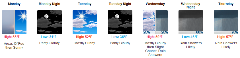
Lower Humidity and Steeplechase Today; Humidity Increase Starting Tomorrow; Rain Next Week;

Iroquois Steeplechase Today!

Hot today, tolerable humidity

The strong ridge of high pressure has really settled in over our area enhancing a southerly flow and keeping cloud-cover low.  These conditions are going to let our temps to creep upwards close to 90. We are on a direct course to come close to 90 degrees today. read more

Record-Tying Weekend Heat; Rain Returns Next Week

Today Looks Hot & Dry

Below is one of the runs from this morning’s HRRR model. It shows a few scattered showers this morning followed by a clearing in the late morning hours.

I doubt rain happens today. As I write, the satellite is clean. The model is probably wrong. read more

Scattered Showers Today; Hot and Dry Weekend; Tropical System Next Week?

Chance of scattered showers today

The HRRR and NAM 3km models are showing some agreement today as they spell out spotty showers.  An upper-level shortwave trough will be influencing our weather for parts of the day today.


The humid, summer-like conditions continue for our area.
Expect temps to crawl into the upper 80s with dew points settled into the low 60s. It’s going to be a hot day! read more

Unsettled Weather Today thru Friday; Hot & Humid Weekend

It’s getting humid. We will be muggy for the foreseeable future as dew points get into the low 60s.

It’s time to dust off the trusty dew point interpreter, updated for 2018:

“Unsettled” weather has arrived, aka summer in Middle Tennessee. read more

Sunny and Dry Today; Scattered Showers Wed thru Fri; Hot & Dry Saturday?

Sunny and Dry Today

A loop of current satellite imagery shows the lack of clouds over our area. For today, our weather is being heavily influenced by a ridge of clear, dry weather to our west.  Expect today to be warm but dry. read more

Rain Chances Today & Wednesday Night - Thursday, then Comes Summer Weather

The models think today will be sun-filled, less humid, with a high temperature at 81º and falling dew points in the 50º range.

However, our atmosphere remains the same as it was yesterday. We remain on the back side of the system that brought us gusty winds, heavy rain, lightning, and small hail yesterday and last night. This afternoon and tonight, most storm ingredients will be there. Plenty of instability. Dry air aloft and “cold pools” sitting atop us, both help storm development. read more

Bit of Overnight Rain Possible, More Rain Wed Night - Thu, Weekend Outlook Looks Good

The HRRR was right this morning. Heavy rain, lightning, and small hail trucked through between 5 PM and 6 PM.

The HRRR thinks a little more rain is possible in the wee hours of the morning (before rush hour), but of little to no consequence: read more

Watch Out for Rain or a Storm Tonight

It’s sunny now. Expect temps in the 80s.

Sunshine may not last all day. We may see a few waves of rain and storms tonight.

The HRRR model thinks rain with a few thunderstorms will race in from the north early this evening (5 PM or 6 PM or so), and again before midnight. read more

Drenching Today, Nicer Sunday, Rain Returns Monday

Rainy Saturday

Rain moved in early this morning, although it’s been holding back a bit through mid-morning. Rain will increase in coverage and intensity around lunch and continue into the afternoon.

How long will it stay? read more

Rain ETAs Today & Saturday

Rain Tonight

Therefore, those with plans outside tonight should have a rain plan, and keep an eye on the radar (and our Twitter feed). Most models have some rain sweeping by at various times tonight, but it looks pretty weak. read more