
Clearing Today
The rain is on its way out.
Below is the HRRR’s thinking on today. Notice it has all rain out by 3 PM.
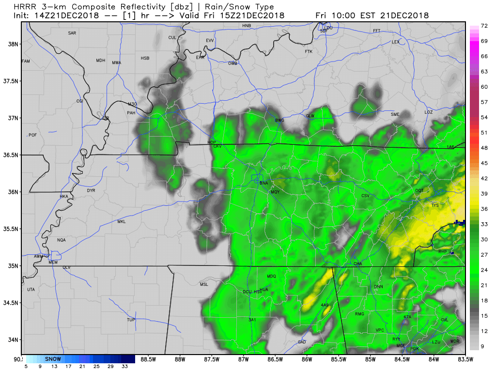
On and off showers will continue through the morning hours and will eventually taper off from west to east as the upper-level low moves north. Additional rain totals could amount up to a quarter inch at most.
As the low moves north, colder air will usher in behind it causing our temperatures to fall throughout the day and winds to kick up into the 15-20 mph range overnight tonight.
There is a tiny winter weather threat across the Plateau this evening, nothing of concern for Nashville.
High Pressure Returns Saturday
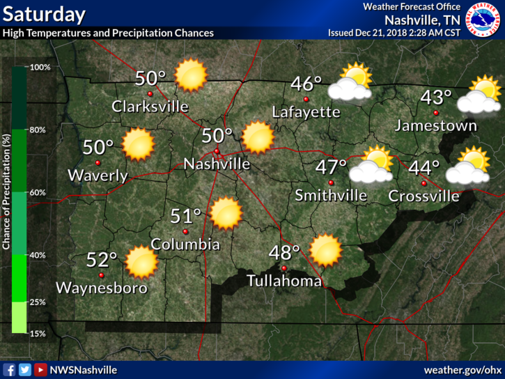
High pressure will take the reigns tomorrow. Clearing skies and sunshine will allow afternoon high temperatures to reach the upper 40s to around 50º.
Editor’s Note: Winds will be south and light, no precip expected, pretty great weather here in December for the Titans game against the Potomac Drainage Basin Indigenous Persons (s/o to Gregg Easterbrook).
We do however have our eyes on Saturday night as a brief pulse of energy will bring the chance for scattered showers beginning late Saturday night. Any rain that does occur will be few and far between, and short-lived. Sunday morning will start at 39º and we will eventually reach the low 50°s by the afternoon hours. Rain may linger into Sunday morning but should be gone Sunday after noon.
Christmas!!
Monday (Christmas Eve) looks mostly sunny and totally dry with a high near 50º.

Monday night looks to be stellar for Santa and his reindeer. Temperatures in Williamson and Davidson Counties will be in the mid-30°s with a mostly clear sky and calm wind.
Christmas Day may bring a couple of isolated showers with it. A high near 50º is expected. However, NWS Nashville noted this, this morning:
Models are quite sketchy with the series of weak [light rain] systems coming up, [but] it is possible Christmas could be totally dry. Either way, nothing significant expected with temperatures trending slightly above normal for Christmas.
Watching Next Week

After Christmas, things could get interesting around here.
Editor’s Note:
The GFS model doesn’t have a big storm system Thu/Fri of next week, but the Euro sure does. It thinks surface low pressure centered near the Ohio River will pull in 60° dewpoints into Middle Tennessee ahead of a powerful cold front expected to quickly sweep through. If this happens — and storms to our south in Alabama don’t block our inflow of warm, Gulf of Mexico air — strong thunderstorms will develop with a severe component. No one is sounding any alarms, because model accuracy at this range is poor, the GFS and Euro models wildly disagree, and the Euro thinks a storm cluster near the Gulf Coast could shut off our storm-making air. But it’s worth talking about given the time of year and all the traveling/not working going on. Dewpoints to 60° with a cold front that strong in late December is Do. Not. Want. Ride a Relaxy-Taxi if you have storm anxiety, just know this may develop into Something Important to Watch as you develop/solidify bowl, holiday, travel plans.
We will update on this as we get closer.

Categories: Forecast Blogs (Legacy)
You must be logged in to post a comment.