Beautiful Today; August Heat and Humidity Return For The Weekend

Pleasant temps for another day!

Mid 80s for the high temps today. Northwesterly winds continue to push dewpoints down into the low 50s. Long story short, it’ll be a beautiful day!

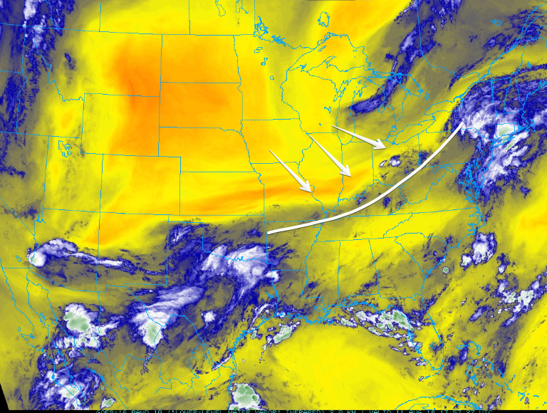
We’ve got clear skies overhead as a surface high is located just to our north. A few clouds from a disturbance out west could wander into Williamson and Davidson counties sometime today, but no rain. read more

Storms Possible This Afternoon, More Likely Late Tonight; Humidity Relief Arrives Tomorrow, Lasts Through Friday

Severe storms should develop along the Mississippi River later today. The system will move our way and is expected to weaken on arrival.

Details

The Storm Prediction Center has us placed within its “Marginal risk” (1 out of 5) of severe weather today. UPDATE 8:00pm SPC has now upgraded parts of both counties to a “slight” (2 out of 5) risk of severe weather. read more

Rain In The Afternoon/Evening Today & Tomorrow; Marginal Severe Weather Monday(?)

Dodging Showers in the Afternoon

The air over Nashville is still pretty saturated, so storm formation is likely. Good news: rain cooled-air and plenty of cloud cover will keep high temps in the mid 80’s. Dewpoints remain in the low 70s. read more

High Humidity, Rain, with Storms Today & Tomorrow

Here Comes Rain, Storms Also Possible

High temps today will push into the low 90s with dewpoints in the low 70s. Humidity is oppressive. Models think precipitable water totals between 2″ and 2.5″ (not that it’ll rain that much) will arrive tonight, indicating arrival of a soupy, sweaty airmass. read more

Dry Today; Rain & High Humidity Return Wednesday; Humid & Rainy Weekend

Humidity Drop Today

Thanks to a continuing stream of dry air, dewpoints will be dropping into the upper 50s today. Sinking air is keeping clouds away, allowing the sun to warm us into the low 90s.

Isolated showers out west should not make it to us tonight, as the HRRR model below shows. read more

Dodging Late Afternoon Storms; Mostly Dry Sunday; Clear But Hot Start To The Week

Attending an outdoor event tonight? See below for details:

A weak surface boundary has set up to our northwest (above – traced in white). It’s going to push southeast during the day, bringing afternoon rain/storms to Middle Tennessee. read more

Rain/Few Storms Today; Heat And Humidity Return For Weekend

Rain With A Few Storms

A shortwave trough will push the stalled front through Middle Tennessee today, causing some showers/storms throughout the day. We could see 0.1″ to 0.3″ of rain here in Nashville, but local amounts should be higher if you’re caught beneath a downpour. read more

Afternoon Storms Possible Again Today; Rain Likely Later This Week

Summertime heat has returned and we are going to feel every bit of it today. The high temp will hit close to 95°, with heat index values pushing into the upper 90°s.

Any rain showers or storms popping up over us will be caused by daytime heating and the breaking of the cap. Where they’ll form is anyone’s guess. The HRRR (below) takes its shot at a prediction. read more

Decreasing Rain Chances Today/Tomorrow; Hot Temperatures Return This Weekend

High temps will stick close to 87° today, dewpoints are holding steady in the upper range of uncomfortable.

Dodging Showers

We’ll experience a typical hot, humid, summertime storm pattern today. The HRRR (below) has a few storms going up over Davidson and Williamson counties in the early afternoon. read more

Walking the Rain/Dry Line

If you were mostly east of I-65, you got some OK rain overnight. Cocorahs observations:

Today we’re stuck on the line between wet and dry.

Rain is happening to our east, divided by a surface front over Middle Tennessee. Sinking air (shown by yellow arrows below) has set up west, behind the front, harshing our rain vibe. read more