Light Rain Mid-Afternoon; Cold Front Arrives Tomorrow Afternoon; Chilly End of the Week

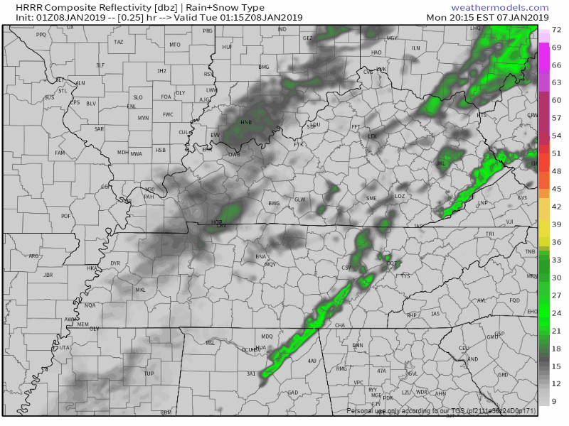
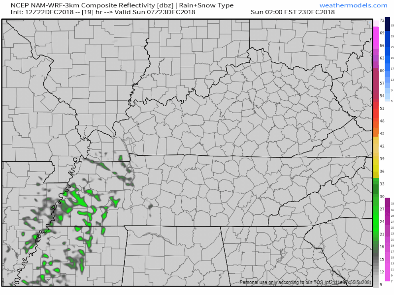
A few sprinkles are hanging around just east of Nashville at the 9 PM update. More light showers should develop overnight. Still no thunder expected with these.

HRRR has these light rain showers hanging overhead during the morning commute, but they’ll be on the way out by late morning and gone by afternoon. Cold front and dry air arrives tomorrow afternoon.

Tuesday

Overnight clouds will, again, leave us with a warm start to the day at 51°. We’ll warm to the low 60°s before the cooler, drier air arrives in the afternoon.

After sundown you’ll begin to see temps falling, and by Wednesday morning we’ll be much cooler! Bundle up Wednesday morning as we start in the low 30°s.

Cold and Dry Wednesday Through Friday

Wednesday and Thursday will be sunny with morning temps in the low 30°s/upper 20°s, and high temps in the low 40°s. By Friday our high temps push into the upper 40°s as we prepare for our next weather maker.

As the next system moves in we’ll already have relatively cold air in place, making it easier for frozen precip to fall. Models are still unsure of the outcome as each run seems to change its solution for the weekend. As of now, we think there will likely be rain or snow, but probably just rain. This does not look like a true snow event even if we were to see some. It would melt on contact, or shortly after sunrise Saturday. Again: this is mostly likely going to be just rain, and it’s even possible we won’t see anything at all.

We’ll be keeping a very close eye on the coming weekend as models continue to work out their outcome. Stay clicked here and @NashSevereWx on Twitter for more updates!


Sunshine is Here! Watching For A Wet Monday; Return to Normal Next Week

The rain has ended, the clouds are gone and the sun has returned for the weekend! 

We’ll see an afternoon high around 58°, unseasonably warm for early January (47° is normal). Once the sun goes down, though, temps will drop into the mid 30°s.

If you plan to take advantage of this dry weather, make sure you bring a sweater along for the ride! Or be a tough guy, that’s up to you.

For Sunday, we can expect the same weather, albeit a few degrees warmer. High pressure, which has brought us our clear skies will slide to our south. Wind flow around this high pressure center – seen as the yellow arrow below – will turn our winds to the south, bringing warmer temperatures north. Expect high temps in the low 60°s. 

Watching For A Wet Monday

Another weak cold front is expected to push through Tennessee Monday evening into Tuesday morning. The weak front will bring a wave of energy through, but there likely won’t be enough moisture in the air to support heavy rain. We can see on the NAM 12km run below, a line of showers develops to our west, but as it approaches the midstate it breaks up. Only light rain is expected.

High temperature of 60° expected, with an overnight low in the low 50°s.

Tuesday Won’t Cool Off Until Late

Light rain showers could stick around through Tuesday’s early morning hours, but the rain should be gone by afternoon. We’ll have a high temp in the low 60°s before the cooler, drier air begins working into Nashville and Williamson County. Overnight temps will drop into the mid 30°s by Wednesday morning.

Rest of the Week

Cooler. Calm weather settles in, with daily morning lows in the mid 20°s and highs in the mid 40°s to finish out the week.

The only precip we expect in the next seven days is the aforementioned light rain Monday into Tuesday morning.


Rain Returns Tonight, Sticks Around All Day Friday; Weekend Looks Great!

This morning’s rain has come to and end. For the bulk of today, we’ll stay dry with thick clouds remaining overhead. These clouds will help to keep us cool with a high around 47°.

More rain will arrive this evening as a low pressure center slides eastward from the Great Plains. The HRRR and NAM both think the rain should arrive around 9 PM. Our forecast low is 39°.

Rainy Friday

As the low pressure continues its march east, we’ll be soggy all day Friday. Heavy, widespread rain through the midday hours, with rain chances decreasing into the evening. The NAM shows the rain pushing off to the northeast by the midnight hours Saturday.

Rain will keep us relatively cool with a high temperature hovering in the low 50°s.

Drying Out By Saturday & Sunday

The weekend weather has our…….

Rain should be gone by Saturday morning, beginning a dry weekend. Morning low’s in the 30°s, easily warming into the upper 50°s for both Saturday and Sunday. Sunday may even get into the lower 60°s.

If you plan to be outdoors, it’s looking great!

Wet weather could return Monday with the arrival of another cold front, but we’ll keep you posted as the next work week draws nearer!


Update on Titans Weather, & Next Week’s Snow Chance

If you read this blog this morning, the blue ink is new.

Today – Dry, Temps in the 40’s

Most of the low clouds will mix out of our area from West to East today. As they do, high clouds will be establishing themselves as a front approaches. Great afternoon to watch some college football.

Editor’s note:


Other Editor’s Note: Will’s a Clemson grad. If Clemson were playing Tennessee (LOL right) in the semifinal today there would be Words, but since they’re not, no man, woman, or child should stand between Will and his Clemson devotion. I once saw him stand up to 6 grown (intoxicated) South Carolina men downtown (they were in town to play Vandy) and Will gave them a Huuuuuge “GO TIGERS.” The South Carolina dudes wilted.

Tonight – Dry, Temps in the mid 30’s

No big changes expected tonight. Cool temps with a light north wind. Find a fire pit, enjoy.

Some very light showers should pass just south of us. No model has them coming through but don’t be surprised if you get a few sprinkles tonight.

Sunday – Mostly Dry with a Late-Day Warm Front – Temps near 50º

On Sunday, a surface low will develop over the southwestern US and begin its eastward march. This won’t impact us until much later Sunday night. Which begs the question:

Titans vs. Colts

Temps in the upper 40°s for kickoff, staying steady throughout the game. Calm east/southeast wind of 3 to 4 mph. 

Will it rain? Maybe, more likely during the end of the game:

  • The NAM3 model has a showers in the area before the 7:20 PM kickoff. See below, running from noon Sunday to 3 AM Monday:

For the game, this is off and on light rainfall, with occasional moderate rain, briefly.

This is just the NAM3 model, with a pro-rain bias.

  • The HRRR model is my favorite. It’s not perfect, but it’s quality, and it is finally in range. Anyway, here it is from noon Sunday to 11 PM tomorrow night:

It thinks no rain for us at the beginning of the game. By 11 PM, the rain still isn’t here — but it’s on the doorstep. So, maybe some fourth quarter rain if the refs are tossing lots of laundry and Luck’s passes hit the earth? It’ll be close. The next run of the HRRR at this range is due in about 4 hours; I’ll update that then. And, of course, we’ll be watching and live-tweeting the rain Sunday night.

  • The Euro model thinks very light rain will arrive around 8 PM, and continue into the second half of the game. Rainfall rates are very light, around 0.01″ per hour (that’s not rain, that’s a spritzing), increasing to 0.1″ per hour closer to midnight. This is more of a dampening than a rain, and it’s possible it will fall more like a mist or drizzle than a rain.

When models fail to agree like this, it’s frustrating. Such is future prediction.

There is no indication of, or concern about, a lightning delay during the game, but I don’t think we’re totally clear of a remote lightning chance because the Euro spikes the K index after midnight and if that’s off by just a little, then, well, we may see a few bolts. That disclaimer aside, lightning is exceptionally unlikely for the game.

With the late start time and the warm front pushing through, it’s better to be prepared for a few gametime sprinkles before heading out.

NYE Forecast

Monday, the surface low should begin moving to our north and east, causing our winds to increase significantly. Gusts upwards of 35 mph are possible throughout the day.

We’ve got good news and bad news for your NYE evening.

Good news first: Any rain in the area SHOULD be gone from Nashville by the late night celebrations; with the wind becoming calm. I’m nervous about this because it’s a super close call.

Now the bad news: Until the late night, it’s going to be a windy, rainy, gross day. Our friends at the NWS Nashville office say we could see 1 to 2 inches before the rain finally moves to our east Monday evening.

So, looks like the new year will begin wet. We’ll be watching this very closely and will continue to keep you updated!

Next Big Event: Thursday – Friday, Rain to Snow?

Models disagree.

The Euro says a prolific rainmaker to our southeast will pass close enough to us that we’ll get its colder NW side. Thursday looks wet. The question is rain or snow?

Temps very early Thursday morning should be below freezing aloft – which may make some snow aloft because science – but with temps from 5,000 feet down to the surface expected above freezing Thursday morning, any snow falling aloft should change back to rain before it arrives on the earth. So, mostly rain Thursday morning.

Thursday afternoon’s high is 44°, obviously warm enough to keep all precip rain.

But Thursday night, as the system pulls away to our E and NE, much colder air and precip should wrap around the back side of the system, setting us up for a chance of wintry precip into the wee hours of Friday morning. The last two Euro model runs show this.

The GFS model totally disagrees. It’s doesn’t even think it’ll rain. It tracks the rain system south of us more to the east (the Euro tracks it northeast), so not only no rain, but also no rain. See below:

The Euro is a better model. Give it more weight. But GFS isn’t trash. Your crap apps probably are hedging bets by putting in a less than 50% chance of snow Thursday night/Friday morning. I think that’s fair, I think 20%-30% is more like it. The chance of accumulating snow is even lower than that.

And even if we get some flakes Thursday night into Friday morning, the ground will be wet and warm, and we’re expecting temps Friday afternoon near 50°. It would melt fast. Sorry, sledders.


Wind Advisory & Rain Today; Music City Bowl Update

A Wind Advisory has been issued for both Davidson and Williamson counties from 6 AM today to 6 AM Friday.

With this we can expect sustained south winds of 15 to 30 mph with gusts upwards of 45 mph. Hold on to your hats!

Active Weather Day Ahead

The following radar gif goes through 11:00 PM tonight.

As you can see from this, light, off and on rain should pass through this morning and afternoon.

Then, around 5 PM or so, give or take an hour or two, a main line of very heavy rain will arrive and stay here at least a few hours.

No severe weather is expected. The Storm Prediction Center has us within an area of general non-severe thunderstorms. If storms happen they’ll be contained in this line of very heavy rain.

Remember, winds will be strong enough to destroy your umbrella.

This afternoon, our high temps will push into the mid 60°s. Overnight rain and clouds will keep our temps from falling too low, into the upper 50°s.

Friday – Music City Bowl Weather Update

The NAM model has been doing a pretty good job so far with this system, so I’m picking up right where I left off from Thursday’s forecast.

For Friday, expect a gross, steady rainfall into the morning hours. High temps in the low 60°s, with the rain ending around lunch time.

If you plan to attend the Music City Bowl: rain should hang around through the morning hours, and a few sprinkles could still be falling by the 12:30 PM kickoff, but for the most part we think the rain will be gone for the game. Good news for the wind, the Wind Advisory expires at 6 AM, marking about the time winds will be calming. Winds could still be breezy [sustained 8-10 mph] out of the west for kickoff, but will be calming as the game goes on.

The wind will shift from the south to the west and finally the northwest, marking the arrival of cooler air for Saturday morning.

Drying Out on Saturday

The cold front will have taken over by sunrise on Saturday – morning temps in the mid 30°s!

No rain expected as of now, high temps in the upper 40°s, it’ll be a great day to be out and about!

Sunday

Another upper level low is expected to develop over the southwestern US and push east throughout the day on Sunday. Our winds will shift to the south, bringing moisture and warmer temperatures back to the mid-state as the day progresses. Highs should top out around 50°.

The uptick in moisture could lead to a few showers in the afternoon/evening. Officially, rain chances stand at 40%.

Planning to attend the Titan’s game? You may need to pack a poncho.

Editor’s Note: I still think this rain may pass southeast of us. It’ll be close. Draw few conclusions.


Roller Coaster Weather: Dry Today, Wet Tomorrow, Dry Christmas Eve, [Possibly] Rainy Christmas Day

High pressure is here today, leaving us with sunny and mostly-clear skies.

Our high temp will rise into the low 50°s. Tonight’s low will fall into the upper 30°s.

As for getting out and about today: it’s a great day for it! If you’ve got outdoor plans, expect calm winds from the south with a max speed of 8 mph, with no rain for the afternoon kickoff.

Next Rain-Maker is Already in the Works – ETA Sunday Morning

Models predict rain begins in the wee hours of Sunday morning. Both NAM and HRRR agree it’ll be around 3 AM and will last until early afternoon. See NAM3 model, below.

Sunday’s high will again flirt with 50°, while the overnight low will fall to around 30°.

Christmas Eve & Day

Christmas Eve (Monday) looks to be pleasant again with dry skies. Temps near 50° are expected, with an overnight low close to freezing.

A few scattered showers are still expected for Christmas Day, but no thunderstorms. Temps a few degrees warmer than Christmas Eve.

Next Notable Weather – Late Next Week

On Wednesday, another strong low pressure center is expected to dip out of the Rockies and pass well to our north. Due to its northern path, we’ll have above average temps than normal.

A few models think thunderstorms are possible Thursday, with an outside chance of a strong storm or two. Currently (a) too much uncertainty + (b) models giving reason to think they won’t be that strong = low concern.


Rain Continues Today/Tomorrow Morning; Drying Out Saturday

Periods of on-and-off rainfall continue today. We could see upwards of 0.5″ of rain through midnight tonight, the NAM shows below.

Clouds will keep us a bit cooler than we have been with a high creeping into the low 50°s. Tonight’s low will remain in the low 40°s.

Rain Friday Morning, Drying Out by Evening

Rain continues on Friday. Periods of on again, off again showers will cover the area – another 0.25″ of rain possible – but only for the morning. By afternoon, dry, cool air will begin wrapping into the system, which will begin to taper off the precip. High temps hover around 45°, temps falling to mid/low 30° after sunset.

By late afternoon, we could see a very brief switch over to wintry precipitation with no impact. Anything that reaches the ground will melt.

[Editor’s Note: Wintry precip is not in the official forecast for us, so pay special attention to the underlined words above. Not expecting any problems.]

According to the NAM, rain should be done by early evening. If you have outdoor plans, keep in mind that light drizzle could hang around past the rain cutoff.

Winds will pick up around sunrise; breezy at about 16 mph with gusts to around 25 mph. This will make the day feel colder than it truly is. Winds won’t calm until midnight.

Nice Saturday

A very pleasant day returns on Saturday as high pressure takes over and we dry out.

Calm winds will switch from the west to the south as the high pressure swiftly moves east. This will allow for slightly warmer temperatures from our south to move north once again. High temps will struggle to reach 50°, morning low in the low 30°s.

Christmas Eve & Day

Looking ahead to next week and Christmas, models are still working out the answer. They’re showing a zonal flow – no major weather events. Even with zonal flow a few shortwaves could pass through, bringing clouds and very low rain chances.

Although models are varied right now, NWS Nashville is calling for “no significant [weather]” for Christmas Eve and Christmas.


Dry & Nice Today/Tomorrow; Rain Moves in Early Thursday & Lasts Into Friday

Pleasant and Dry Today and Tomorrow

High pressure continues to dominate our weather. Today, high temps will brush the upper 50°s. It’s going to be a beautiful day!

Wednesday looks mostly dry with a high temp in the upper 50°s, low 60°s. As our next rainmaker moves closer we’ll begin to see and feel those effects. Our winds will will shift to the south (bringing the slightly warmer temperatures and plenty of Gulf moisture).

Clouds begin moving in Wednesday evening, with rain chances on the rise.

Wet Thursday & Friday

Rain expected to begin as early as very late Wednesday, will be settled in by Thursday morning. Gross, steady rain with a few heavy showers in the mix, but nothing severe.

We could see 0.5″ – 1.5″ of rain from Thursday morning to Friday afternoon – no flooding is expected at this time. It won’t be raining the entire time but you’ll want to have a Plan B if Plan A is “be outside where it’s dry,”

By Friday, as the low clears the midstate, cold air will begin wrapping in from the north. No impacts from any frozen precipitation – the moisture will be gone and surface temps too high. Confidence is increasing there will be no snowy/wintry impacts here from this system.

Cold air arrives on a dry Saturday morning: morning low in the upper 30°s. Daytime high in the mid 40°s. There’s some chance of a little rain Sunday afternoon, but nothing like what the Titans saw in New Jersey last Sunday.


Rain Today; Drying Out Tomorrow; Dry Start for Next Week

Scattered Showers Today

Low pressure center continues to swirl over north/central Mississippi, it will continue to keep spotty showers over us for today.

We continue to be a few degrees above normal for mid-December, with a high in the mid 50s. Clouds hanging around after sunset will keep overnight lows in the mid 40s.

Drying Out Tomorrow

Deep moisture will remain over us at least until early Sunday morning, which could give us a few lingering showers.

NAM keeps light/scattered showers through late morning. HRRR has us completely dry before sunrise.

Early morning temperature close to 41°, warming slowly to a mid-50s high by evening. 

Dry for the Early Week

By Monday, a large high pressure dome will settle over the southeast. Due to the high pressure’s north winds, our overnight lows going into Monday morning will fall into the mid 30s.

Editors Note: WOW

This will be our weather pattern for the first half of the week: dry, calm north winds, overnight lows in the low/mid 30s.

Dry Weather Doesn’t Last

Similar to last week, we have a high pressure ridge dominating the first half of the week before the strong upper jet takes over on Thursday.

A surface low is expected to develop and pass right over the Midstate. We can’t say for certain what kind of weather will be associated with this. Pieces of the puzzle still missing.

Until then, we’ll be keeping an eye on things and keep you updated with any changes!


Rain/Sleet/Snow Possible Tonight/Early Tomorrow

A light, drizzly rain has worked its way into Davidson and Williamson counties this morning. By now we should just be seeing rain fall, but a flake or two could be in the mix.

This drizzly mess will switch over completely to rain by late morning as it spreads over the midstate. Rain and moisture will push north, fighting against dry air as it goes. This will keep high precipitation totals to our south, where rain will fall more heavily.

Later this evening the surface low bringing moisture to Tennessee will track into the Florida panhandle. As it pushes east, cold air will begin wrapping into the moisture over us. That’s when we’ll begin seeing the changeover to frozen precip – snow, sleet, and freezing rain.

As of this morning, NWS Nashville had this to say:

Rain is expected to change to a
wintry mix of snow, sleet, freezing rain and rain across far
northern portions of the area this evening. To the south, all
rain.

The I-40 corridor still looks to be the dividing line between seeing snow and rain late tonight. And so because of this, a Winter Weather Advisory has been issued for northern counties in Tennessee – Davidson is included, but Williamson is not.

Winter Weather Advisory will go into effect tonight at 6PM and will remain in effect until noon on Sunday.

Sunday

By early morning, we could see the wintry mix spread across the northern half of the midstate, including Nashville. Across the counties in the advisory, snow accumulations are expected to be less than an inch.

After sunrise and temps begin to rise, any frozen precip should switch back over to rain.

Sunday evening, we could have another piece of energy push through from the north, bringing a few more snow showers. No accumulation is expected.

Stay tuned here and to Twitter for more updates with this event.