Latest Official Hourly Observation:

Tonight – Chilly Rain – Midnight Temp 41
HAPPY NEW YEAR EVERYONE!
Rain is starting to move into Middle TN tonight. It’s too warm for it to fall as snow.

Latest Official Hourly Observation:
Tonight – Chilly Rain – Midnight Temp 41
HAPPY NEW YEAR EVERYONE!
Rain is starting to move into Middle TN tonight. It’s too warm for it to fall as snow.
This afternoon’s weather “is the warmest we’ll see for quite a while.” (NWS).
Thursday
The RAP shows the rain-changing-to-snow approaching tonight, Midnight to 6 AM:
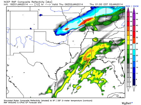
Most of the rain will fall before the freezing line pushes through:
Latest Official Hourly Observation:
Tonight – Cold & Clear
6p 38 . 9p 33 . 12a 31 . 3a 29
Cold, but not too bad.

New Year’s Day – Mostly Sunny, Warmer, Rain Very Late – Morning Low 24 / Afternoon High 51
Thursday
GFS Model
A cold front arrives Thursday morning, pushing rain out ahead of it, as shown by the GFS model:
Around noon Thursday, the cold front pushes through middle Tennessee, changing the rain to snow:
Latest Official Hourly Observation:
New Year’s Eve – Sunny – Morning Low 23 / Afternoon High 45
6a 24 . 9a 31 . 12p 40 . 3p 44 . 6p 38 . 9p 33 . 12a 31
New Year’s Eve day will be sunny and warmer.
Current Hourly Observation:
Tonight – Brine Watch
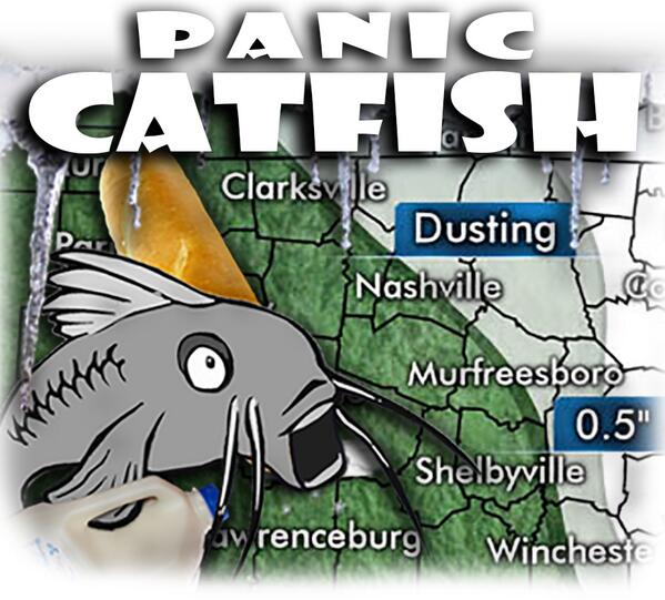
He’s freaking out.
We’re not getting emotional. We prefer to stay calm during this crisis.
Here’s what (we think) we know:
Latest Official Hourly Observation:
Today – Rain Ends; Mostly Cloudy – Afternoon High 50 / Midnight Temp 34
9a 43 . 12p 48 . 3p 49 . 6p 42 . 9p 37
Yesterday’s rain is gone.
Latest Official Hourly Observation:
Tonight – Rain Continues
Sunday – Rain Ends; Flurries Late? – Morning Low 39 / Afternoon High 51
6a 40 . 9a 43 . 12p 49 . 3p 50 . 6p 42 . 9p 37
Latest Official Hourly Observation:
Tonight – Mostly Clear & Chilly – Midnight Temp 37
Saturday – Increasing Clouds; Rainy Evening – Morning Low 30 / Afternoon High 55
Latest Official Hourly Observation:
Tonight – Clear & Cold – Midnight Temp 32
Friday – Warmer & Sunny – Morning Low 26 / Afternoon High 51
6a 27 . 9a 35 . 12p 46 . 3p 50 . 6p 43 . 9p 39
You must be logged in to post a comment.