
Current Radar
Y’all. Sharknado4 comes out in 2 weeks.
Sharknado is a lot of fun. Best viewed with friends, responsibly consumed alcoholic beverages, and crazy-low expectations.
Highs Monday through Sunday: 95°, 95°, 94°, 96°, 96°, 95°, 95°. Although the GFS model has a few late week temps over 100°, the GFS model has joined the “It’ll be hot, but not that hot” movement started by the Euro model this afternoon. Maybe not over 100°. But still….
The heat & humidity combo is the bigger deal. Afternoon dewpoints will hover around 70° all week. According to this unofficial chart, we’ll end up somewhere between ruined hairdos and needing fish lungs.
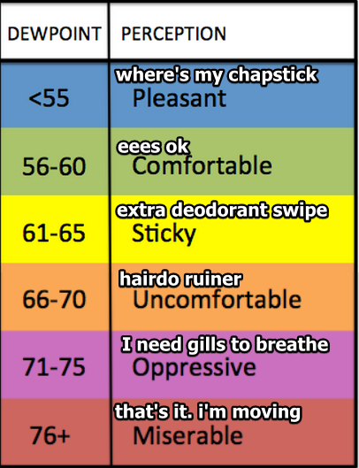
Hot Week Ahead
Current Radar
The correct pronunciation of the G in GIF is…
— NashSevereWx (@NashSevereWx) July 16, 2016
Looks like the “hard G” is winning. Gif as in “gift.” I was in the “soft G” camp, until I read this:
Drying Out This Evening, Then Continued HOT
Current Radar
Tonight: Drying Out, Cooler – 9PM 80°

As a trough slides east of our area towards the Plateau, we will dry out for any evening plans. Don’t forget, tonight is a night of music and barbecue at Nashville’s Rib and Jazz Festival downtown in Cumberland Park! Mmm…barbecue.
Rain Possible Tonight, Hot and Humid Weekend Ahead
Current Radar
Tonight: Chance of Storms – 9PM 81°

Thunderstorms have formed to our northwest today in response to an approaching cold front. The latest high resolution models have these storms holding together long enough to make it into our area this evening/overnight:
Rain Tomorrow. Weekend Outlook Looking More Promising
Current Radar
Tonight: Rain Clearing? Think so.
Rain came early today. Still have a few lingering showers that should exit as we head into the evening hours. Partly cloudy skies will follow behind, may eventually get some clear skies overnight.
Little Rain Chance Tonight, Showers/Storms Return Tomorrow
Current Radar
Tonight: Few Clouds, Outside Chance of Little Shower Late
For the most part, expecting clear to partly cloudy skies through the evening. The early evening time frame should remain rain-free. As we head into the late evening, early early AM hours we have a very slim chance of seeing some showers.
Quiet Tonight, Warm and Humid Conditions Continue
Current Radar
Tonight: Cooler, Rain Moves Out – 9PM 78°
After the sun sets, any storms will deteriorate. That’s summertime! An enjoyable, cooler night is ahead with temperatures falling into the upper 70s by 9PM.

Wednesday: No Rain? Don’t Be Fooled…Hot and Humid – Wake Up 73° High 93°

NWS Nashville is keeping the rain chances out of our forecast for Wednesday. However, with dew points in the low 70s and low 90s for high temps, it’s hard to ignore those numbers. Hot + humid + forcing mechanism = BOOM!…a thunderstorm is born.
Chance of Showers All Week, Better Chance Tomorrow
Current Radar
Tonight: Rain Chance Continues
Not a whole lot will change as we head into the evening hours. Skies will remain cloudy and we could see some more rain through the evening (that will all depend on where showers develop during the day). Temps are expected to barely cool only dipping down into the low 70s. It will also be very muggy through the evening with our dew point temps sticking in the 70s overnight.
More Rain Coming This Week. When’s It Going to Get HOT?
Current Radar
The Rain Never Came Today
Rain and storms remained stuck near the MS/TN/AL borders. A few showers lifted north toward our air, but those were zapped by drier and more stable air.
We did get a pretty cool roll cloud, though.
Roll cloud? @NWSNashville @NashSevereWx pic.twitter.com/F0F3yfmptc
— David Howe (@DHdeeder) July 10, 2016
Higher Rain Chances on the Way
Rain chances Monday and Tuesday will be higher than the common “summertime pop-up” set ups. Let’s quote NWS!
As the northeast trough lifts out and heights rise, deeper moisture lurking just south of Tennessee will return northward late tonight through Monday. Also, a weak upper trough that has been sitting over north Mississippi will slowly lift north northeastward. These features will combine to spread scattered showers and a few storms across the Mid State on Monday and into Tuesday as well.
More Rain? It’s Summer, So….
Current Radar
Sunday – An Area of Light Rain Should Lift North Toward I-40
It’s raining this morning at the Alabama/Tennessee border.
We think that rain will creep north.
The HRRR model illustrates:

Notice how this model lifts what looks like a pretty big blob of light rain through the morning, then by 1 PM, it vanishes. We don’t think it’ll happen exactly like that, but we do think the rain should be decreasing as it comes north. It may not even make it.
You must be logged in to post a comment.