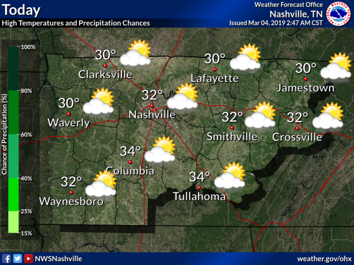
Cloudy Today, Worse (Wet & Cold) Sunday, Sunday Night Snow Meh, Old Man Winter Returns Monday

I write from Severe Weather Awareness Day at Trevecca. It’s from 9 AM to 4 PM today. The Blue Bell ice cream guy if here with a LOT of ice cream and Erik is here from Storm Watch Plus — we have 200 severe weather alert apps to give away for freeeee! The event is free here too. Parking free. It’s all free. Even the ice cream. Free!  All your fave broadcast mets are here. Also NWS people and other exhibitors. Details here. read more

Coolish Temps for Now, Showers Return Sunday, COLD next week

Intern 4.0 here, a special thanks to David, Will, and Andrew for letting me make a “guest” appearance on today’s blog.

Dreary Conditions Continue Today

Technically speaking we have a very slim chance of a scattered shower this morning, but so far showers have stayed well to our south. So I wouldn’t count on any showers, but be advised if you were to feel a sprinkle or two. As you head outside this morning, you may notice the abundance of clouds overhead. Visible satellite imagery shows the sun rising over these clouds, even if we can’t see it here in Middle Tennessee. read more

Cooler with Rain Today; Light Showers Friday Morning; Beautiful Saturday; Cold Front Sat/Sun

A weak cold front is stretched across Middle Tennessee, bringing scattered showers and keeping afternoon high temps in the mid 50°s. Light rain could continue into tonight.

Friday

Morning commute will be met with temps in the mid 30°s, with high temps warming into the upper 40°s. Light scattered showers are possible in the morning and early afternoon, which the NAM 3km shows. By evening a high pressure center should set up over the Great Plains which will push rain chances out. [Editor’s Note: NWS keeps us dry on Friday during the day and introduces low end rain chances beginning in the evening. Future forecasts may change in response to model data, but we’ll update rain chances over on Twitter.] read more