
Today – Pleasant – High 65°
Pleasant air will filter in behind the dry cold front which passed by, leaving us cool and dry.

Sunday – October-Like Weather – Wake Up 44°, High 65°
High pressure will continue to pump in fall weather.

Today – Pleasant – High 65°
Pleasant air will filter in behind the dry cold front which passed by, leaving us cool and dry.
Sunday – October-Like Weather – Wake Up 44°, High 65°
High pressure will continue to pump in fall weather.
Today – Sunny & Dry – High 78°
A dry cold front will work its way through Middle Tennessee late this afternoon into the evening, bringing sunny conditions with it.

Saturday – October-Like Weather Returns – Wake Up 51°, High 66°
Today – Cool & Dry – Low 65°
The overcast skies are in no hurry to depart.

Track our proximity to clear skies on visible satellite!

Friday – Mostly Sunny – Wake Up 49°, High 78°

Wednesday Night – Lingering Showers & Cloudiness – Low 50°s
As an upper level low continues to pull off to the east, it will spin light, off/on showers and cloudiness into our area.
Yesterday’s rain totals:
Davidson County saw between 2″ & 3.75″
Williamson County got mostly between 2″ and 2.5″, with a few locations in the western county racking up over 4″!
We dodged a bullet yesterday. The Cumberland Electric Company Reported that over 2,000 people in Clarksville lost power last night — in the area with a tornado signature on radar.

Today the NWS is surveying what appeared to be a long-track tornado-producing supercell which moved across western Middle TN late Monday afternoon.

Well, that was close. Thankful to escape with only a few reports of 60 mph winds after seeing this at 5:15 PM:
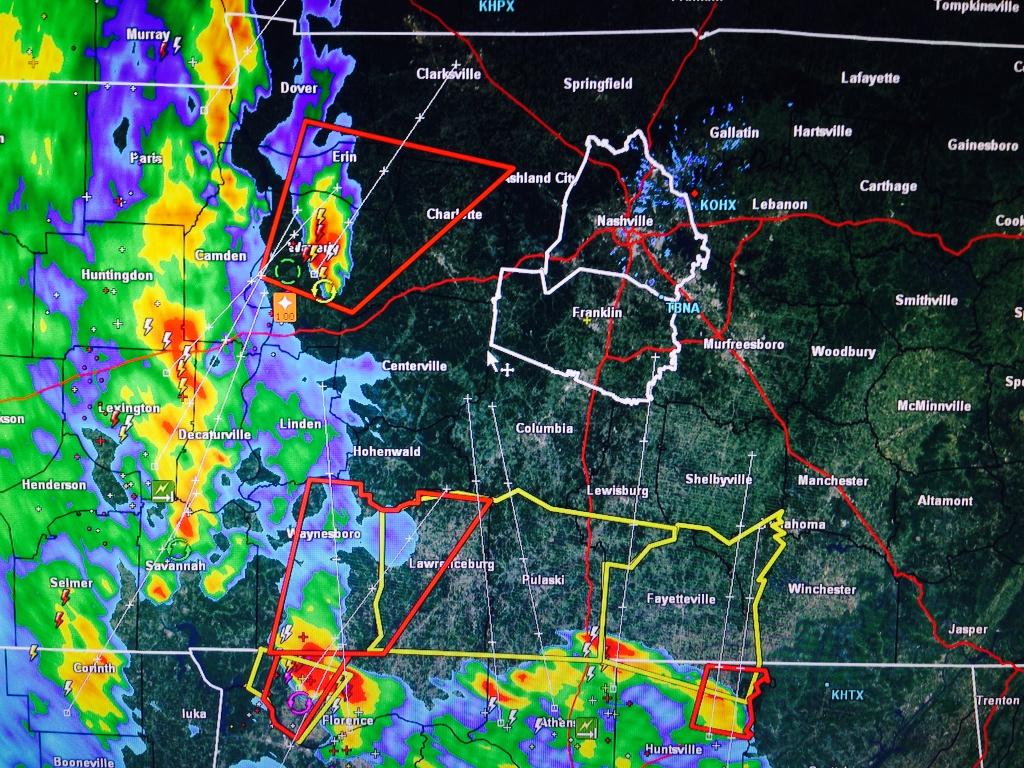
Other communities to our W and NW were not so lucky.
The Tornado Watch is set to expire at Midnight. It’ll likely formally be cancelled before then.
Current Radar Loops:


At 3:56 PM, the NWS posted this:

Keep an eye on those storms flying out of N Alabama.
Tornado Watch Until Midnight
Here is the Watch Information. Notice the Hazard Likelihood at the bottom:
Current Radar Loops:
Severe Weather Likely Tonight — High 82°
3:00 PM Update
SPC’s latest update:
2% to 5% probability of a tornado occurring within 25 miles of you:
15% to 30% probability of a 58 mph or greater wind gust occurring within 25 miles of you:
Summary: Windy Monday – Severe Weather in 2 Rounds – Round 1: late afternoon/early evening Monday – Round 2: main squall line ETA 3 AM to 6 AM Tuesday morning – Damaging Winds, Torrential Rain, Tornadoes possible in both rounds.

You must be logged in to post a comment.