Current Radar
Tonight – Steamy
HRRR was wrong today; afternoon rain/storms didn’t form here (they were southeast of us).

Summer makes liars of weather models.
When the sun sets, any rain chance will set with it.

Current Radar
HRRR was wrong today; afternoon rain/storms didn’t form here (they were southeast of us).
Summer makes liars of weather models.
When the sun sets, any rain chance will set with it.
Current Radar

It’s hot, it’s humid, so much so, everyone unfavorite game of thunderstorm uncertainty is being played. When, where, how bad? Yeah, we don’t know. It’s like guessing where exactly in an about-to-boil big pot the first water bubble will surface.
Current Radar
Storms are approaching the TN/KY border to our north. Check-in on Twitter for updates.
Both the HRRR and NAM4 models have a chance for rain this evening:
Both models are picking up on a frontal boundary sagging south into northern Tennessee. If the boundary can hold together, a few showers and maybe a scattered storm are possible, especially earlier in the evening while the sun is still up.
Current Radar
Things should be dry for your evening plans!
It’ll be warm, though. Overnight lows will be in the low 70°s.
Slim rain chances will follow us into tomorrow, as well:
The NAM4 model isn’t picking up on much of anything, but its not impossible that we could see a scattered shower throughout the day.
Current Radar
Conditions will be warm this evening thanks to the sunshine we’ll get throughout the day.
But, the rain will continue to stay away:
It’s not out of the question that we’ll catch a shower or storm overnight, though chances aren’t overly impressive:
Current Radar
Thunderstorms (1 severe at this time) are in the area as of 6:15 PM. Please check-in with us on Twitter @NashSevereWx for updates!
Showers and storms will continue into the evening hours:
Current Radar
Hope you enjoyed your July 4th weekend! Also, congratulations to USA Women’s Soccer for winning the 2015 World Cup!!

We really aren’t expecting rain, but HRRR thinks a few showers may dance across both counties:
Current Radar
For tonight’s Fourth of July 2.0, the weather will be much better. Those Fine Americans who braved the rain in Nashville for fireworks last night had to contend with low clouds which made the show look like a Grateful Dead concert. Clouds were forming at 356 meters, which is under 1,200 feet. Not good fireworks weather.
Current Radar
630 PM Update: A Flash Flood Warning is in effect for Williamson County. If you’re in the green box, my advice is to stay home.
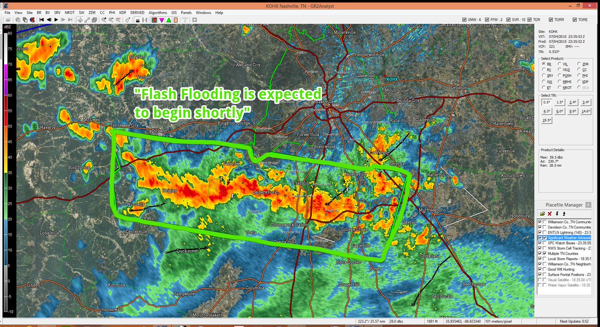
The stationary front remains north of us. Rain and storms have been firing off it as it feeds off the humid air mass overhead.
Current Radar
A stationary front has set up just north of us. Rain and storms are firing off it as it feeds off the humid airmass overhead:
Expect scattered showers — some heavy at times — to move east this afternoon.