Current Radar
Today – A Cooler and DRY Day! – High: 77º
After all this drizzle ends, we’re in store for a nice day, if you like cooler temperatures non-existent rain chances….


Current Radar
Today – A Cooler and DRY Day! – High: 77º
After all this drizzle ends, we’re in store for a nice day, if you like cooler temperatures non-existent rain chances….
Current Radar
Tonight – Rain Moving East
As that bowling ball of low pressure rolls slowly east, it’ll take the rain with it.
Tuesday – Very Small Chance of Rain – High 78°
Current Radar
Tonight – Flooding Concerns
We’ve seen a LOT of rain. I thought we would shake it. We haven’t.
Through 7:30 PM
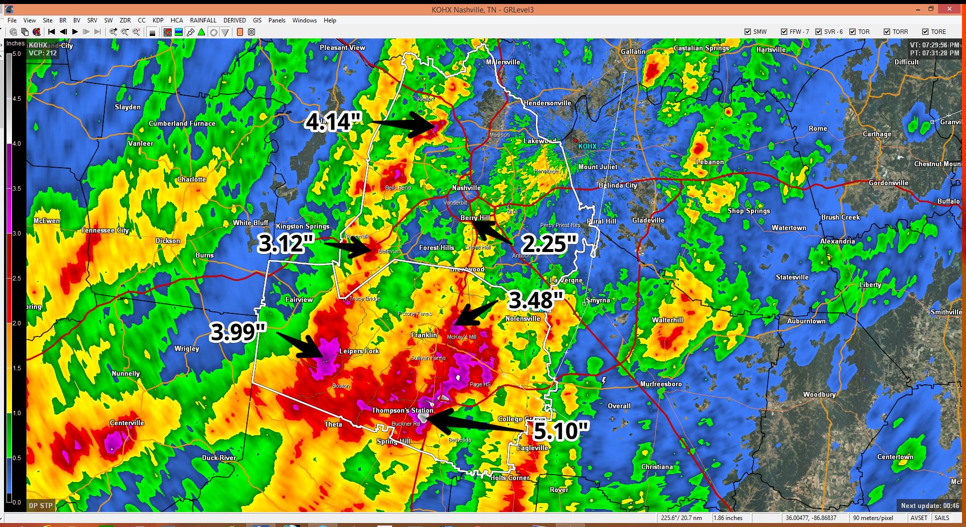
An Areal Flood Warning, although recently cancelled for Davidson Co, is effective for Williamson County until 10:15 PM.
Current Radar
Tonight and Sunday – Rain/Storms Hanging Around – High 82°
Shower and thunderstorm chances will continue through the overnight hours tonight into Sunday morning. The potential for severe thunderstorms (damaging winds, not hail or a tornado) will continue during this time, but it’s rather unimpressive. Without some sun-fueled heating, they’ll struggle to mature.
It’s dodgeball time!

Tonight – Maybe Some Showers and Weak Thunderstorms

It may rain today and through the weekend. In fact, we think it will rain, but when and where, we don’t really know. Tonight and tomorrow’s weather is without an obvious focal point to initiate showers and storms, hence the uncertainty. If you want meaningless quantification and LOL ETAs, please consult a wide array of crap apps. We would rather embrace uncertainty with honesty, than guess and hope we hit the lottery so you think we are super geniuses).
Current Temps and Radar
Yay it is Friday!!

Today – Showers and Thunderstorms Possible Later this Afternoon . H: 84°
(Editor’s Note: It may rain today and through the weekend. In fact, we think it will rain, but when and where, we don’t really know. This weather pattern contains no obvious focal point to initiate showers and storms, hence the uncertainty. If you want meaningless quantifications and LOL ETAs, please consult a wide array of crap apps. We would rather embrace uncertainty with honesty, than guess and hope we hit the lottery so you think we are super geniuses).
Tonight – Showers? Probably Not
Early today, models were flirting with sending us some rain and a few thunderstorms. They’ve since backed off that pro-rain idea. We’re seeing showers and thunderstorms slowly begin to appear to our south, and drift very slowly north toward us. However, if you look at the water vapor imagery, we look relatively dry. I’m not real confident we’ll see anything tonight. Our NWS thinks our rain chances tonight are pretty small.
Current Temps and Radar
Tonight – Things Settle Down
So, we had a severe thunderstorm today. Here’s the polygon with the radar turned off so you can see the blobby stuff, which is where we think all the hail fell:
Current Temps and Radar
Today – Widespread Showers and Thunderstorms – H: 86°
The muggy conditions and chance of rain will make you want to run away on this hump day.
Widespread showers and thunderstorms are likely around and after lunch thanks to rain and thunderstorms moving northeast into Middle Tennessee from Arkansas and Mississippi.
Current Temps and Radar
Tonight – Rain Gone, Still Humid
After a lot of rain early this afternoon (officially 0.63″ at the airport), we should be relatively dry tonight. “Little if any [rain] redevelopment is expected,” says our NWS.