Nashville Severe Weather

Severe & Winter Weather Info and Forecasts for Davidson & Williamson Counties in Middle Tennessee

Friday, March 27th, 2026

Menu

  • Home
  • Who We Are
    • About Us
    • Mike & Albree
  • Resources
    • Radar
    • NWS Nashville
    • What To Do: Tornado Watch vs. Warning
    • River/Creek Flood Stages
    • Taking Care of Storm Anxiety
  • Shop Merch
    • Store
    • Shopping Cart
  • Donate
    • Patreon
    • Paypal
  • Follow us on Twitter
  • Follow us on Threads
  • Follow us on Bluesky
  • Follow us on Instagram
  • Subscribe to our YouTube Channel

A Few Chances for Rain and Severe

By Will on Monday, March 9, 2026 @ 9:51 am • ( Leave a comment )

Low-End Severe Risk Today, Stay Connected

By Andrew on Saturday, March 7, 2026 @ 9:00 am • ( Leave a comment )

Cold but Slowly Warming

By Will on Tuesday, December 30, 2025 @ 10:41 am • ( Leave a comment )

Cold and Clear

By Will on Monday, December 29, 2025 @ 1:14 pm • ( Leave a comment )

Eyes on Next Weekend

By Andrew on Sunday, October 12, 2025 @ 4:06 pm • ( Leave a comment )

Cool, Foggy Mornings; Warm Afternoons, Rain-free

By Andrew on Saturday, October 11, 2025 @ 12:05 pm • ( Leave a comment )

Locate Windshield Ice Scrapers, Freeze Warning Monday 3 AM to 8 AM

By David on Sunday, October 21, 2018 @ 3:49 pm

Locate your windshield scraper. You’ll probably need that scraper.

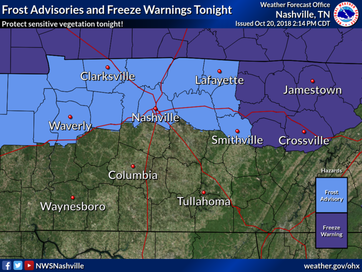
Also cover plants you don’t want freezing temps to kill.

Freeze Warning, Nashville and Will Co., Monday 3 AM to 8 AM

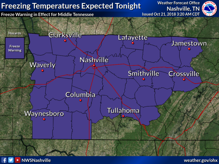
The low is 33° at BNA, 2° colder than last night. Local areas should be colder. Frost is likely with light winds. read more

Freeze Warning Monday 3 AM to 8 AM, Then Boring Fall Weather; Next Rain Chances

By David on Sunday, October 21, 2018 @ 8:32 am

Cover or shelter loved plants and locate your windshield scraper.

The deal with that Saturday night wind

It was a blast of reinforcing cold northern air. During the 10 PM hour winds hit 35 MPH at BNA. They relaxed after midnight and colder air raced in. BNA hit 35° before sunrise. read more

Dry & Chilly Start to the Week; Rain Chances Gone Until Thursday/Friday

By Marti Calhoun on Saturday, October 20, 2018 @ 11:45 am

Frost Advisory has been issued for Nashville Tonight

Frost Advisory for Nashville. 33° to 36°. Sheltered and low-lying areas may see frost producing temperatures for at least a few hours prior to sunrise Sunday. A Frost Advisory means that widespread frost is expected. Sensitive outdoor plants may be killed if left uncovered. read more

Rain to Start the Weekend, Clearing and Cooling Quickly

By Alex Forbes on Friday, October 19, 2018 @ 12:01 pm

Cold Front Inbound

We’ve made it to Friday! Much of the day will be clear with temperatures in the mid to upper-60s. Clouds will being funneling in later this afternoon in advance of a cold front that is set to come through tomorrow. With those clouds, come rain chances. read more

Clear and Dry Today; Rain Arrives Tomorrow Evening, Ending Saturday; Dry and Chilly Sunday

By Marti Calhoun on Thursday, October 18, 2018 @ 11:17 am

Rain today? High pressure bubble says, “no.”

A ridge of high pressure is now settled right over the Midstate, keeping clouds at bay and squashing any rain chance for our Thursday.

High temps today will remain into the low 60s. Dewpoints in the low 30s! That means the gross-humid weather is out for the day! read more

Clear Today and Tomorrow, Rain Chance Friday Night

By Alex Forbes on Wednesday, October 17, 2018 @ 3:06 pm

This Afternoon

Fall is finally starting to settle in, in middle Tennessee!

We are going to continue the pattern of below average temperatures today with highs getting into the lower to middle/upper 60s. As of 3:00 pm, we’re at 68°, pretty close to the average high for this time of year, which is 69º. read more

Light Rain Ending Tonight; Wednesday & Thursday in the Clear; Rain Returns Friday (probably late)

By Marti Calhoun on Tuesday, October 16, 2018 @ 3:42 pm

Light rain arrived mid-afternoon, on time, mostly south of I-40. From NWS-Nashville:

Expect most of the measurable rain to be south of I-40, with perhaps a hundredth or two falling in the Nashville area . . . read more

Colder!

By David on Monday, October 15, 2018 @ 3:20 pm

First, this happened today. Apologies to anyone who read all 100,000 of these.

This is our 100,000th tweet. Below is tweet #1 from August 10, 2009.

Nothing has changed. https://t.co/naWEDdh6YP

— NashSevereWx (@NashSevereWx) October 15, 2018 read more

Rain Ending, Getting Cooler. Cold Mornings Ahead. Early Weekend Rain.

By David on Monday, October 15, 2018 @ 10:43 am

Heavy rain is ending, but it’s not over. Most areas along and north of I-40 got 2″ to 3″.

2" to 3" of rain estimated by radar last 12 hours along and north of I-40. Rain slacking off now. Blue arrows depict approach of a cold front. It's 67° now at BNA, expecting upper 50°s before/around dark with arrival of Jerk North Wind. pic.twitter.com/jgz9kJ14So read more

Off & On Rain This Evening Through Tuesday; Jerk Winds Monday

By David on Sunday, October 14, 2018 @ 8:43 am

Rain hasn’t been terribly heavy today. As of 3:12 pm, radar estimates most of us have received under a 1/2 inch . Blue indicates 1/2 to 1 inch. That doesn’t include many of us…just Joeltinians/Joeltonites. Someone fill us in on what you’re called if you’re from Joelton. We shouldn’t have started guessing, but since we’re here, help. read more

Posts navigation

‹ Newer 1 … 294 295 296 297 298 299 300 301 302 303 304 … 558 Older ›

Subscribe to Blog via Email

Enter your email address to subscribe and receive daily forecast updates directly to your inbox.

Privacy & Cookies: This site uses cookies. By continuing to use this website, you agree to their use.
To find out more, including how to control cookies, see here: Privacy Policy
  • Top categories: Forecast Blogs (Legacy) / Featured Blog / Tweet
Proudly powered by WordPress | Theme: Broadsheet by Pro Theme Design.
 

Loading Comments...
 

You must be logged in to post a comment.