Heat & Humidity Return

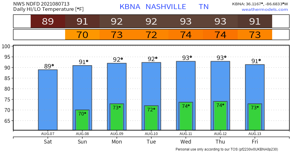
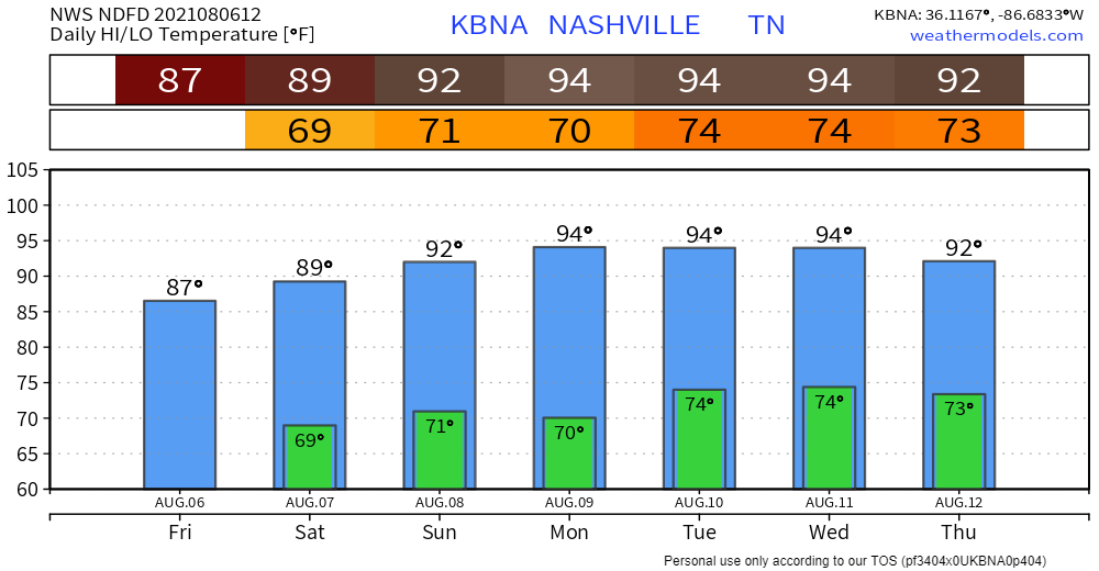
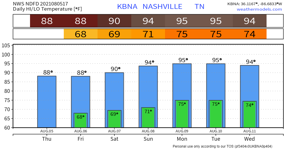
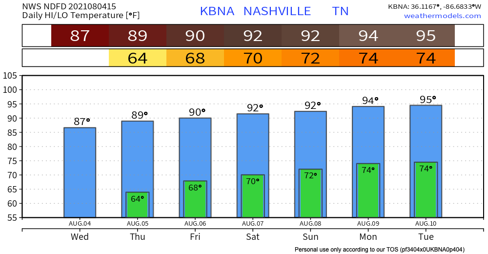
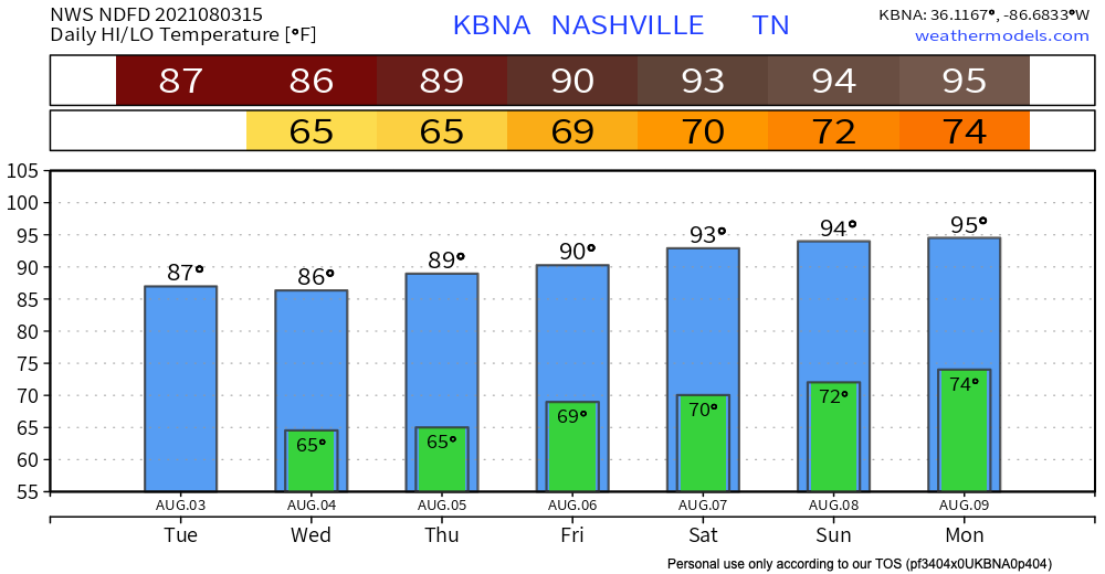
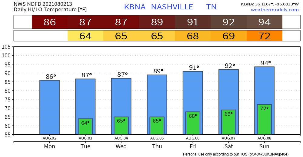
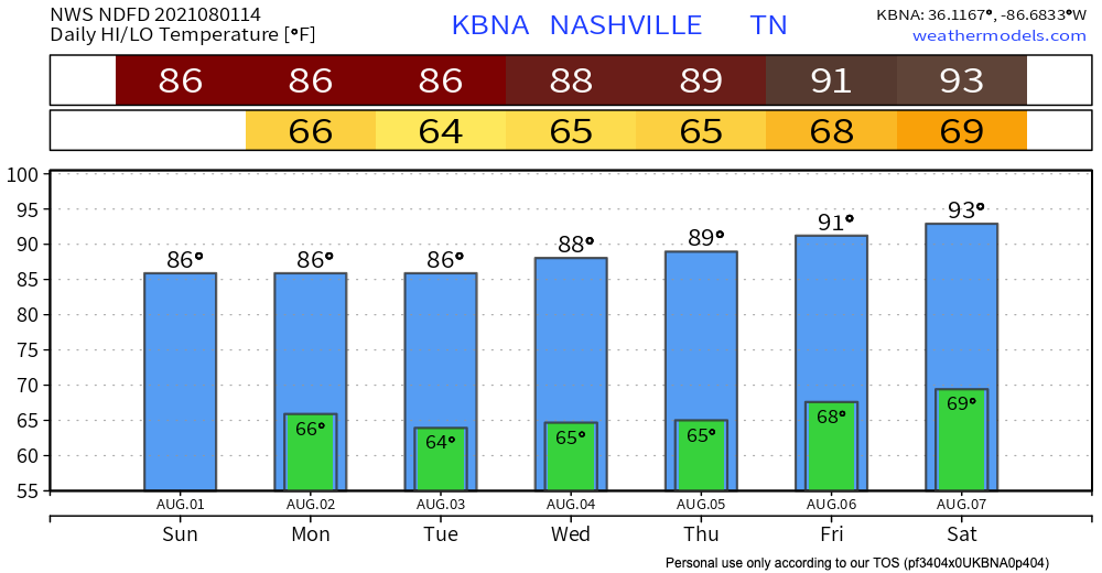
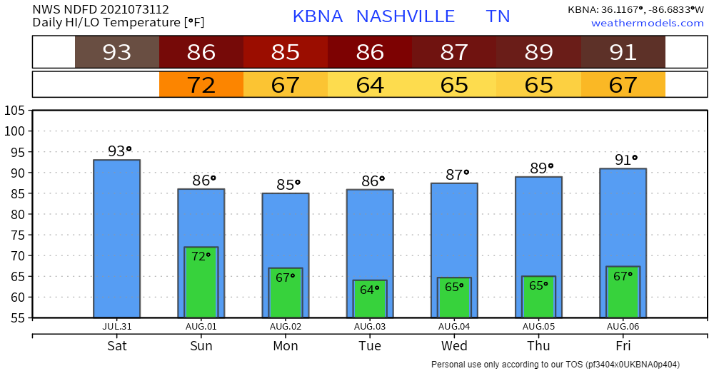
Our cooler temps, lower humidity streak is over. Humidity is up today. It’ll stay there for the foreseeable future. Temps return to normal for August.

No Major Rain Threat

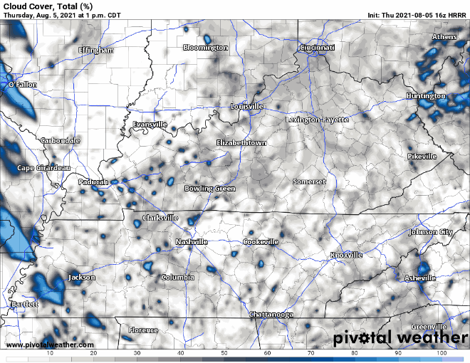
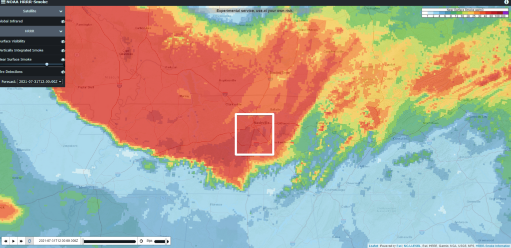
There are a few thunderstorms south of us this morning. They’re moving east and won’t bother us. We may see light rain this morning but the bigger rain and storms should be east of us all weekend. Here is the HRRR model showing the weekend: read more

Rain For Some, Heat For Everyone

Today marks a return to normalcy for August: dewps in the upper 60s and afternoon storms/showers. Highs likely won’t break 90 just yet, but the heat is just getting started.

Rain is back in the forecast today. Model runs are showing activity in the afternoon (see HRRR run below). I say more activity, but we’re not expecting widespread coverage, severe weather, or anything of that nature. Anticipate unpredictable scattered showers/storms here and there, but any action could miss you altogether. Not washout material. Still could delay outdoor festivities. read more

Clear Day Today, Warming Trend Bringing Rain Later

Nothing but dry and warm today. Rain is practically nonexistent in the most current model runs. Some more cloud coverage later today through tomorrow.

HRRR Cloud Coverage, valid Thurs. 1pm – Thurs. 9pm

Highs today are just shy of 90 and dewps in the low to mid 60s. Sticky, but pretty low for August. Tomorrow will be similar, but dial up the humidity a bit (dewps in upper 60s). Highs sneak into the low 90s and dewps hang out in the upper 60s for the weekend. read more

Dry with Temps and Humidity Rising

Pretty Great! Tiny Rain Chance Tomorrow. Weekend: Less Great.

The trend continues! High’s in the upper 80’s today until the weekend. Not expecting any precip today and dew point lingers around 60 woohoo!

Wednesday: Smoke? Rain??

The smoke from the wildfires starts to move out today. Throughout today the yellow line of smoke moves south and out of our counties for a clearer tomorrow shown by HRRR below. read more

Kinda A Great Week. Bit Smoky Tho.

Humidity dropped. Temps not close to 90° (normal August 2 high is 91°). No rain.

Joey Shocked GIFs - Get the best GIF on GIPHY

Wildfire smoke is back. That’s what’s causing the haze in the air.

Smoke levels drop over the next two days. By Wednesday morning (see below) things will be better, but not smoke-free. read more

Three Things About Last Night, & Then Good News

Microbursts dropped out of severe thunderstorms.

Imagine a giant water balloon crashing to the ground. Now imagine you’re an ant on the ground. When that water hits the ground, it pushes wind away in all directions. Straight line winds race away from where the balloon hit and burst, knocking over trees. Microburst winds are intense. They aren’t tornadoes (no upward motion), but microbursts can do low-end tornado damage. read more

Storms and Heavy Rain Possible Tonight, End of Crazy Heat In Sight

First things first, smoke and haze will continue today, as shown below, which has warranted an Air Quality Alert for both counties.

Near Surface Smoke – Davidson and Williamson counties outlined in the white box

For the first time in a few days, our counties are not under a Heat Advisory, but it will still feel very hot and humid. Actual temperatures will be in the mid 90’s and dewpoints in the upper 60’s, which will lead to the heat index being in the upper 90’s. Make sure to drink plenty of H20 and limit your time in the direct sun. read more

Finally Some Relief From the Heat

This warmest low temperature of all time was likely recorded today at BNA. 80º. If we don’t drop below 78º before midnight tonight, we’ll have a new official record. Whether it stands or not, an 80º low temperature is highly unusual. read more

Heat Advisory 11 AM to 7 PM. Heat Index 105°+.

Fog formed on area lakes and rivers overnight. Here’s the sat view of it mixing out.

Today watch for these signs.

Image

A Heat Advisory starts at 11 AM and ends at 7 PM tonight. This means the temp/humidity combo will push the heat index/feels like temp to 105° in shaded areas. Much hotter in direct sunlight. Our local heat index should hit 107° in Nashville and 106° in Franklin. You know what to do. Take breaks, guzzle water, etc. read more