Rain Wednesday. Hot/Muggy Weekend.

Tuesday Night through Wednesday

Look for increasing clouds tonight and warmer with lows in the lower 50s.

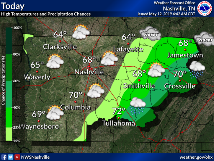
Rain expected Wednesday by late morning, continuing through the lunch hour, ending by mid afternoon. High temperatures will reach into the mid 70s. read more

Below Average Temps, AM Fog; Chance of Rain Wednesday; Warmer/Humid Weekend Ahead

Last year we went from winter to summer. I think we had a half afternoon of spring.

Not this year.

For example, over the past 24 hours the temp was 7° below average. Here’s where we’ve been: read more

Beautiful, then Rain Chances Return Mid-Week

Today

Any lingering showers should move out of the area within the next hour or so, leaving us with comfortable weather for the remainder of the day.

EDITOR’S NOTE:

Tonight

There is a chance we could see an overnight shower and hear a rumble or two of thunder. The HRRR model shows some rain moving in from our west overnight. It should pass before the morning commute to work. read more

Soggy Steeplechase, but Sunny Start To The Week

Tonight

If the current radar trends hold up, We will see only a little passing shower before midnight and drop down to 60° for the overnight low. I don’t think we’ll be totally dry, but it won’t be enough to spoil post DMB/Stadium Yoga plans. read more

Special Event Forecast - Iroquois Steeplechase Edition

Before the first race…

We expect a dry morning. As you’re making the final outfit decisions, know that rain is in the conversation, and the best option is to have a couple options. The rain we had yesterday evening and overnight is gone, but it has left the ground quite soft. After thousands of people and hundreds of vehicles make their way around the infield, it’s going to get muddy. That being said, you won’t need rain jackets as you set up your tailgate spot or unpack linens in your box. We expect a high of 74º at 4pm. read more

Steeplechase forecast: Occasional Rain and Storms

Rest of Today and Tonight

For the rest of our afternoon the skies will remain mostly cloudy, with temps reaching near 73° for our high. The clouds are going to stick around with us as we approach the evening hours, when our next line of showers moves into the area. Rain and a few storms will be arriving sometime between 8pm-9pm and will move through our area overnight. Temperatures will drop into the upper 50s for the overnight low. read more

Weekend Update!

Waves of rain coming.

FRIDAY

The first isn’t much of a wave. A cold front will cross Friday morning. It’ll bring a few light showers. No appreciable rainfall expected. So let’s not count that one. read more

Few Showers Leftover This Evening; Rainy Weekend Ahead

Thursday Night and Friday

Mild and humid with isolated showers and a possible thunderstorm. Areas of fog overnight. Severe weather is not anticipated.

The latest HRRR thinks there won’t be much from this evening through tomorrow afternoon: read more

8 AM Update. Rain Coming. Windy Too. Storms Meh. Severe Concerns Decreasing.

8 AM UPDATE

Looks like a rain + wind event. A few storms possible, main concerns lightning and strong winds.

STORM PREDICTION CENTER PROBABILITIES OF X WITHIN 25 MILES, 8 AM Update

Tornado: we are removed from risk area. Insufficient instability the reason. Previous outlook said 2%. read more

Rainy, Stormy Day. Hazards & Timing.

NWS-NASHVILLE OVERVIEW

Some strong to severe thunderstorms are possible today, with the main threat being damaging winds. Hail and a few brief tornadoes are possible as well, but chances are low. Localized flash flooding will also be possible for areas that receive multiple rounds of heavy rain today. read more