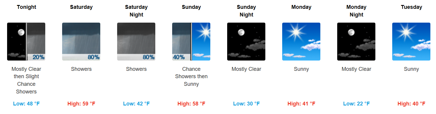
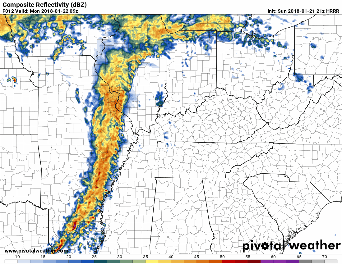
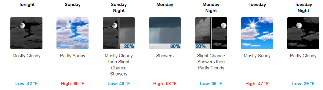
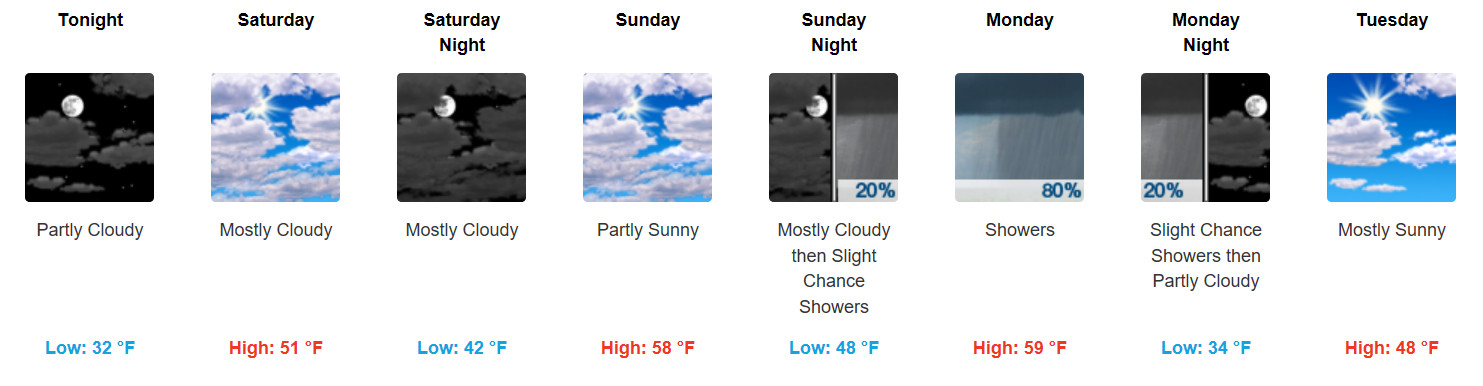
Storms Today, Some Could Be Strong/Severe Again

More Rain, More Storms, Some Could Be Strong

Latest HRRR Model

Showers and storms are again expected to “pulse up” this afternoon and evening across Middle Tennessee. Some could be on the stronger side with a few severe storms capable of damaging straight-line winds. read more

More Showers/Thunderstorms Tonight and Tomorrow, Sunshine on Friday

Showers and Thunderstorms, Some Could be Severe

A few scattered showers continue to move across the area. If you have early evening plans, bring the umbrella just in case.

Into the remainder of the evening, all eyes are on a few lines of showers currently located in western Tennessee. If these showers hold together, which some models think they will, we could see another round of showers and thunderstorms later tonight. read more

Pretty Good Day Today Rain-Wise, But Low Clouds Tonight Not Ideal for Firework Viewing

Update: The Backdrop for Fireworks Looks Better Now

Most fireworks only fly about 1,200 feet up.

Models think “LCL levels” will be low tonight, meaning clouds should be closer to the ground. Some models predict cloud levels as low as only a thousand feet. read more

Shower Chances Continue, Hope for Tomorrow Night

Afternoon/Evening Showers and Thunderstorms Possible

We’ve already seen a couple of severe thunderstorms this afternoon. As always, if you have any damage from today’s storms tweet using #tspotter to report it to our local National Weather Service Office. read more

Hot with Afternoon Shower Chances, Hope for Tomorrow Night


Sunny to Start, Strong to Severe Afternoon Thunderstorms Possible

A typical summertime day is expected with highs in the upper 80s and dew point temps in the low 70s. It’ll be nice and sunny to start, with diurnal heat showers possible later today.

Into this afternoon, we introduce those shower and thunderstorm chances. Latest run of the HRRR, shown below, displays what it thinks will happen today. read more

Lots of Uncertainty, Thinking Afternoon Rain Monday & Tuesday, But Optimistic Both Nights

Warning: Weather models aren’t very good at handling summertime thunderstorms.

Summer storms are very hard to predict, but as a general rule: rain and storms are mostly likely to develop between mid/late afternoon and early evening. read more

Rain & Storms Likely Next Few Days, Here’s Our Best Idea of When They’ll Be Here

There are times weather models can see what’s coming so we can provide you a good, reasonably reliable (not perfect), “when and where.”

This is not one of those times.

Weather models, which in a perfect world should arrive at the same thing, predict different things. Weather models also aren’t very good at handling summertime thunderstorms. read more

A Few Strong Storms Remain Possible This Afternoon/Evening

Welcome to July!

Storms This Afternoon, Exiting By Evening

UPDATE as of 5:00PM CDT: The eastern half of both Davidson/Williamson remain under a “Marginal Risk” (1 out of 5) for damaging winds and some hail.

We’ve seen several showers and thunderstorms impact Davidson/Williamson counties today, some with ~40 mph wind gusts. More could develop through the evening, so we will be monitoring radar for developments. read more

Showers/Thunderstorms Possible Tonight & Tomorrow. However, Lots of Model Uncertainty


“Better” Chance of Showers this Evening

So far today we have stayed, for the most part, rain-free. Latest radar scans do not show a whole lot on the radar, so good news so far. Into the rest of the evening, we will still need to keep an eye on showers attempting to move our way. read more

Warmer, Humidity Going Up, and Storms Possible

Opportunity for Rain/Storms Begins Today

Update: We’ve seen a few showers and storms roll through the bi-county area today. These should dissipate in conjunction with sunset, but heavy downpours remain possible through the evening.

Friday will provide increased rain chances, but particularly Friday night into Saturday. We will need to carefully monitor the potential for strong/severe storms on Saturday. While shear values are not very impressive, instability is high enough that when combined, could produce a few misbehavers. The biggest concerns would be hail and damaging winds on Saturday. All of that being said, we are not yet under any formal severe risk. read more