
This afternoon, a severe thunderstorm developed in Maury County. By late afternoon, rain cooled air from that thunderstorm raced north and set off severe thunderstorms in Williamson then Davidson Counties. Hardest hit was Belle Meade and surrounding communities. High winds brought down trees and power was lost. We got several reports of small hail. Torrential rains caused localized flooding.
It’s “We Don’t Know Exactly When or Where but It May Rain This Afternoon” Season
It’s uncertainty season.
Here’s one reason why ETAs and rain/no rain questions about your outdoor event are very difficult to answer with confidence.
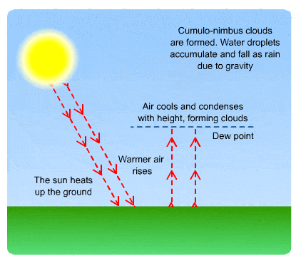
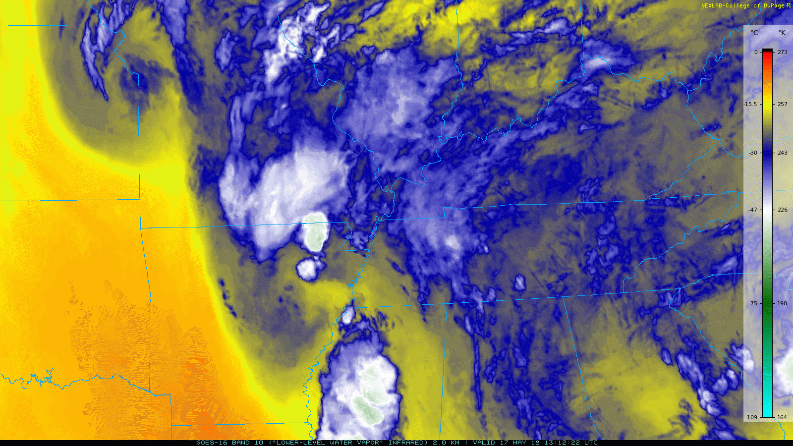
Remember in elementary school when you were hopefully taught rain is basically just a tall cloud. The taller the cloud, the more water it has. When it gets tall and big enough, the water it has is too heavy to stay suspended in the cloud, so the water falls. That’s rain.
Less Showers Expected Today; Few Showers Sunday; Rain Threat Returns Monday
Good news! Looks like today will be a bit drier compared to what we’ve had the last couple of days.
Saturday Afternoon
We do have some model agreement that today will feature less coverage of pop-up showers. This comes from a weak ridge that will be building into our region late today.
Afternoon/Early Evening Showers & Storms Today, Better News for the Weekend
Afternoon-Early Evening Showers/Storms
Today will be another typical southern summer afternoon with temperatures in the low to mid-80s, clouds, humidity through the roof, and the expectation showers will break out by mid-afternoon and freckle the radar.
Afternoon Showers Today; Same Story Tomorrow; Saturday Could be Dry
As discussed yesterday, days like today are hard to predict.
Today is expected to be like yesterday, with rain showers appearing as the sun heats the surface.
Earlier Today Through Lunch Time
Due to overnight cooling, most storms died during the night. An increase of moisture closer to the surface left us with widespread cloud cover and thick fog in some places. The fog mixed out as the sun came up and warmed us up.
Decisions!

Future prediction is hard.
This week we’re at our outdoorsiest…during what’s statistically the wettest week of the year, mid-May.
Will it rain [insert location, date, time] because I have [plants to water, graduation ceremony, a game, going out with friends and thinking about a white top, it’s field day, etc] and I have to decide what to do?
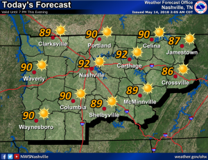
Hot and Sticky Today; Rain Chances Increase in the Afternoon; Rain Chances through End of Week

Hot and Humid again
Heat and humidity continue today. The ridge of high pressure responsible for the sauna is still in place, but as we move into the afternoon, it’s going to begin breaking down. Until then, our temps are still going to flirt with record breaking highs; the record high in Nashville on this day is 91, set back in 1962. We’re forecast to hit 91 today. Dewpoints are going to hang around the upper 60’s all day, so it’ll be another sweaty one.
Hot & Humid Today, Tomorrow Begins a Rainy Pattern
Our short streak of 90 degree days continues today: 92º. If we get there, it will tie the May 14 record set in 1881.
Humidity remains high with dew points be in the mid-to-upper 60s. Keep an eye on the little ones — their bodies don’t regulate heat well, and they’re not yet acclimated to this summertime airmass.
Hot & Humid Monday; Rain Chances Begin Tuesday & Run Thru the Weekend
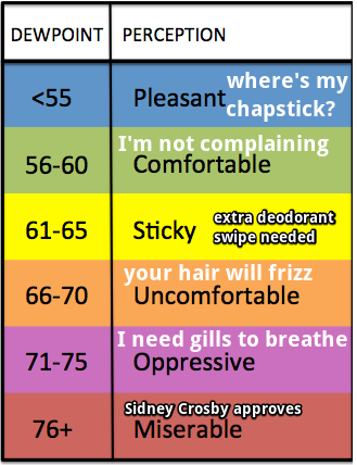
Humidity will increase again Monday, somewhere between sticky and uncomfortable.
Low 90s temps with dewpoints in the mid 60s will make it feel like mid 90 temps in the heat of the afternoon.
Another Reminder to Check the Back Seat
From the National Weather Service:
First Real Hot & Humid Days of 2018: Today, Monday, & Tuesday. Then a Decent Chance of Rain.

Yesterday, for the first time in 2018, BNA hit 90. This was early: on average, we hit 90 on May 29. Look for highs today of 91, Monday 93, and Tuesday 92.
For us, yesterday’s heat was a “dry heat,” with dew points at or below 60. Dew points (the humidity) will rise today, tomorrow, and Tuesday, into “extra deodorant swipe needed” and “your hair will frizz” levels.
You must be logged in to post a comment.