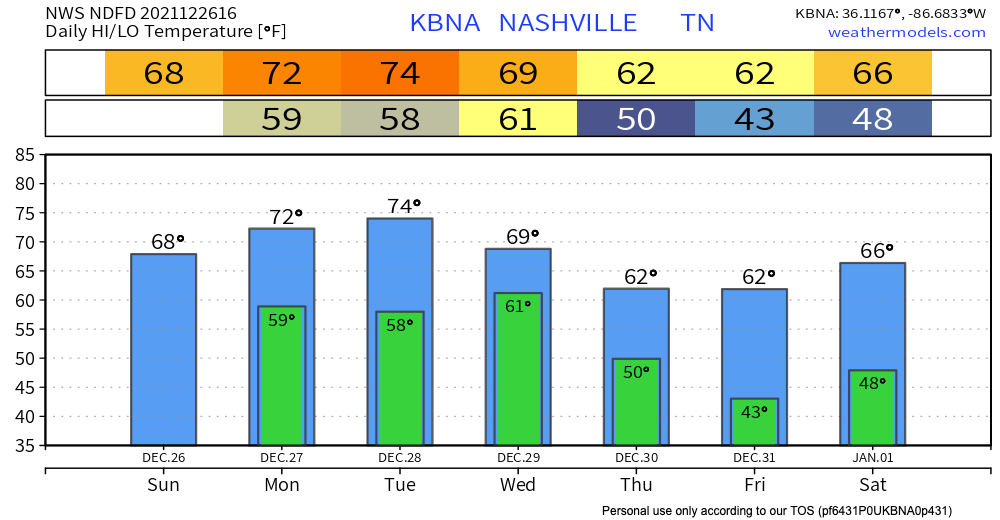
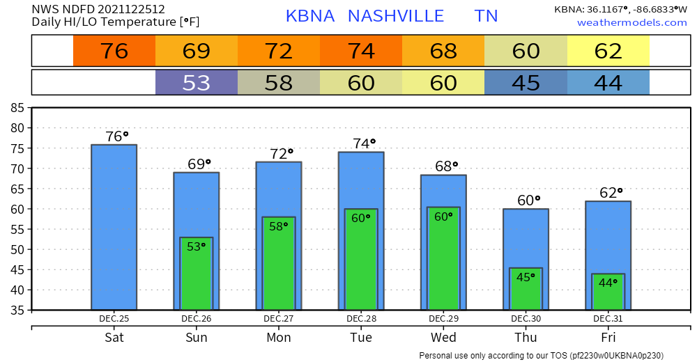
Highs are running 20-25 degrees above normal this week. Rain is possible every day, most likely Wednesday and Saturday. Those are the days we are concerned about.
Below shows Monday and Tuesday, no worries about it.

Highs are running 20-25 degrees above normal this week. Rain is possible every day, most likely Wednesday and Saturday. Those are the days we are concerned about.
Below shows Monday and Tuesday, no worries about it.

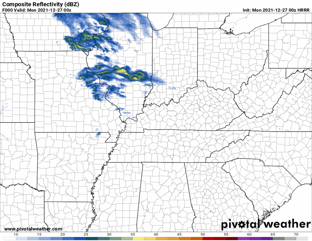
Below the HRRR model shows rain off and on through Tuesday night, not much, mostly Monday night and Tuesday, no washout.
Then Wednesday even more rain as seen by the Euro model below.
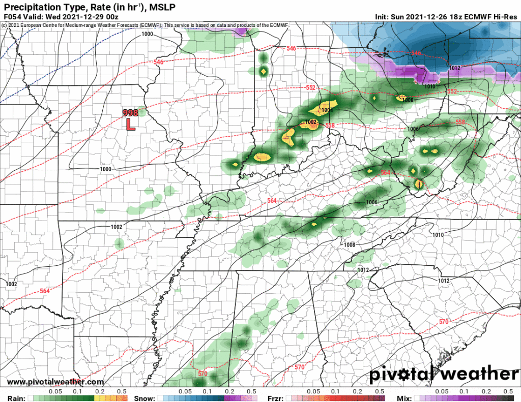
Now this may be a washout. Perhaps even thunderstorms but the severe threat is more likely well south of us as depicted by SPC:
No rain today.
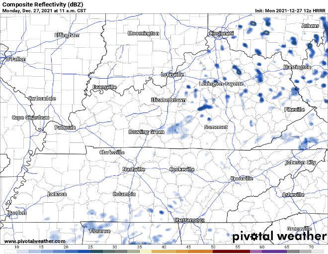
Rain chances increase Monday and Tuesday. HRRR shows spotty showers Monday afternoon and evening. Looks like on & off rain rather than a steady one. Nothing to worry about.
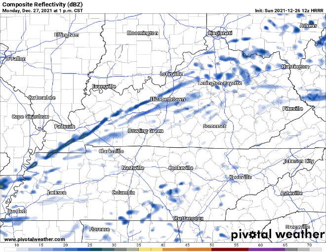
Tuesday’s rain chances look better, especially Tuesday night. Our first weather maker of the week will bring more steady rain Tuesday night into Wednesday. See HRRR below:

Winds will calm down this afternoon and tonight. 76° today would be the record high for Christmas, set 5 years ago.
Few raindrops may cross by tonight. Inconsequential. Alter no plans. HRRR model:
Monday and Tuesday may bring showers. Models think just rain, off and on, more Tuesday than Monday. Nothing to worry about either day.
Hello, dear reader, Merry Christmas Eve. My father is in the other room, appalled while watching The Office for the first time, comedy is occurring here.
But first.
Did you spend Eighty Thousand Dollars on a Christmas vehicle? Big red bow on it? Got plans for a cheesy reveal featuring your perfect teethed fam? And you hatched and executed said plan without saying anything to your spouse about it? Well if you have that thing parked for the Big Reveal near a roof sheltering children, the wind is coming for you my friend, strong enough to blow four of Santa’s reindeer and the front right side of his sled through its rear window, windblown by an act of justice, comedy, or tragedy, and a moment of introspection surely awaits.
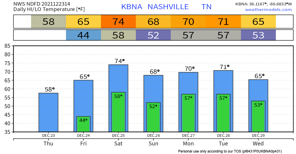
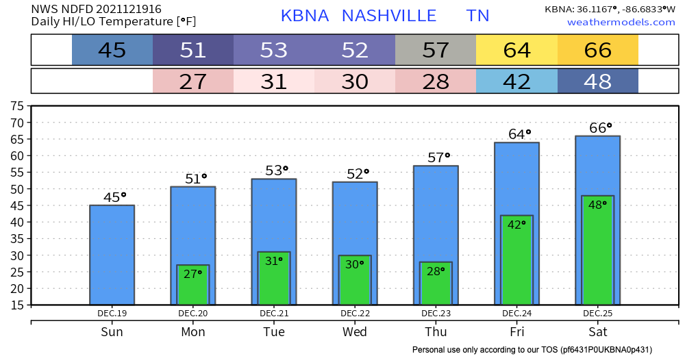
Who’s ready for a warm Christmas. Despite dropping below freezing last night, our warming trend starts now and is expected to stay until the end of the year.
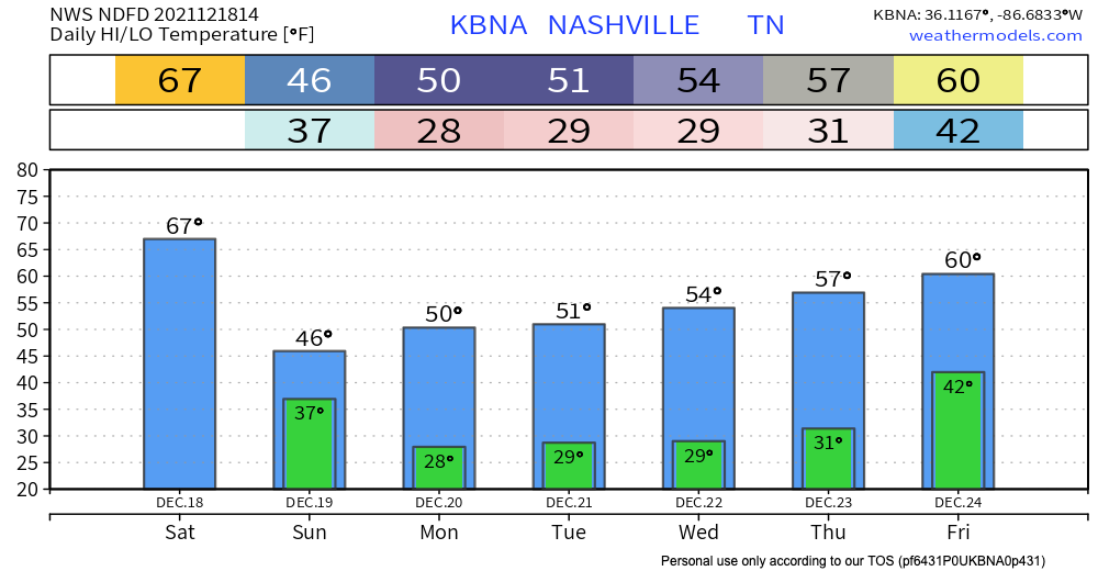
Our highest recorded temperature for December is currently 79 degrees, and we are expected to come fairly close to that on Saturday. Maybe Santa will bring us a new record.
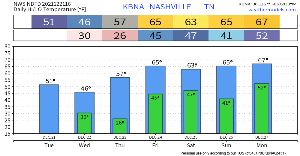
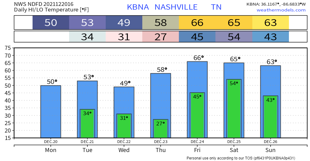
A cold front comes through our area today bringing a slight cool down. Highs in the low 50’s today drop down to just below freezing tonight. Wednesday is our coolest day this week with temps not getting out of the mid 40’s. Overnight lows are quite crisp in the mid to upper 20’s.
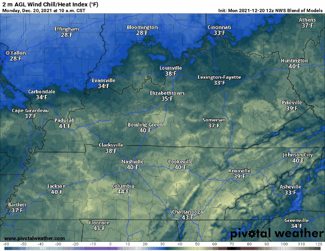
Normal temps, some sun. Wind chills drop tonight, time stamp upper left:
Additional moisture rolling in tonight plus near freezing temps equals a low probability chance of freezing fog early tomorrow morning. If you are out really early and see fog on the road ahead – especially on bridges and overpasses – a thin layer of ice may have formed on the road. The potential hazard will be brief. Just be aware. It’s freezing fog szn.
The warm temps are gone, and the cold blast is here. Highs in the low 40’s today. Temps will dip into the high 20’s overnight. Mother nature has decided it’s December again.

If you enjoy these cold temps, enjoy them while they last. Temps climb all week. 50’s through Thursday, but then mid 60’s over the weekend. Christmas is supposed to be warm, right?

Rain will be off and on today. It’s coming in from Arkansas (where rain is a bit heavy, with a few thunderstorm), but as it moves toward us the storms will dissipate and the rain will break up into light rain, turning off and on. Temperatures will be in the upper 60s.
You must be logged in to post a comment.